Country:
 Belgium
Region:
City:
Latitude and Longitude:
Time Zone:
Postal Code:
IP information under different IP Channel
ip-api
Country
Region
City
ASN
Time Zone
ISP
Blacklist
Proxy
Latitude
Longitude
Postal
Route
IPinfo
Country
Region
City
ASN
Time Zone
ISP
Blacklist
Proxy
Latitude
Longitude
Postal
Route
MaxMind
Country
Region
City
ASN
Time Zone
ISP
Blacklist
Proxy
Latitude
Longitude
Postal
Route
Luminati
Country
BEASN
Time Zone
Europe/Brussels
ISP
Techit.be Srl
Latitude
Longitude
Postal
db-ip
Country
Region
City
ASN
Time Zone
ISP
Blacklist
Proxy
Latitude
Longitude
Postal
Route
ipdata
Country
Region
City
ASN
Time Zone
ISP
Blacklist
Proxy
Latitude
Longitude
Postal
Route
Popular places and events near this IP address
Evere
Municipality of the Brussels-Capital Region, Belgium
Distance: Approx. 936 meters
Latitude and longitude: 50.86666667,4.4
Evere (French: [evɛʁ], Dutch: [ˈeːvərə] ) is one of the 19 municipalities of the Brussels-Capital Region (Belgium). As of 1 January 2022, the municipality had a population of 43,608 inhabitants. The total area is 5.08 km2 (1.96 sq mi), which gives a population density of 8,503/km2 (22,020/sq mi).

Brussels Cemetery
Cemetery in Brussels, Belgium
Distance: Approx. 1475 meters
Latitude and longitude: 50.86972222,4.42277778
Brussels Cemetery (French: Cimetière de Bruxelles; Dutch: Begraafplaats van Brussel) is a cemetery belonging to the City of Brussels in Brussels, Belgium. Located in the neighbouring municipality of Evere, rather than in the City of Brussels proper, it is adjacent to Schaerbeek Cemetery and Evere Cemetery, but should not be confused with either. The grounds include many war memorials, including a large monument to the soldiers of the Battle of Waterloo by the sculptor Jacques de Lalaing.

EFQM
Non-profit foundation
Distance: Approx. 673 meters
Latitude and longitude: 50.86878,4.40423
EFQM (the European Foundation for Quality Management) is a non-profit membership foundation established in 1989 in Brussels, when CEOs of 67 European companies subscribed to the policy document and declared their commitments to EFQMs missions and values. EFQM works with over 50,000 organisations from across Europe and beyond, including organisations such as BMW, Robert Bosch, Aramco, Siemens and Huawei.

Bordet railway station
Railway station in Brussels, Belgium
Distance: Approx. 529 meters
Latitude and longitude: 50.8774,4.4097
Bordet railway station (French: Gare de Bordet; Dutch: Station Bordet) is a railway station in the municipality of Evere in Brussels, Belgium, operated by the National Railway Company of Belgium (NMBS/SNCB). The station lies on line 26, between Haren and Evere railway stations. The station is located under street level, at the crossroad between the Chaussée de Haecht/Haachtsesteenweg and the Avenue Jules Bordet/Jules Bordetlaan, next to the border with the City of Brussels.

Evere railway station
Railway station in Brussels, Belgium
Distance: Approx. 901 meters
Latitude and longitude: 50.86694444,4.40027778
Evere railway station (French: Gare d'Evere; Dutch: Station Evere) is a railway station in the municipality of Evere in Brussels, Belgium. The station opened on 19 July 1926, is located under street level, and can be accessed via the Rue Auguste De Boeck/Auguste De Boeckstraat. The station lies on line 26, between Bordet and Meiser railway stations.

Schaerbeek Cemetery
Cemetery in Evere, Belgium
Distance: Approx. 1248 meters
Latitude and longitude: 50.87083333,4.42
Schaerbeek Cemetery (French: Cimetière de Schaerbeek; Dutch: Begraafplaats van Schaarbeek), officially Schaerbeek New Cemetery (French: Nouveau Cimetière de Schaerbeek, Dutch: Nieuwe Begraafplaats van Schaarbeek), is a cemetery belonging to Schaerbeek in Brussels, Belgium, where the municipality's inhabitants have the right to be buried. It is not located in Schaerbeek itself; rather it is partially in the neighbouring municipality of Evere, and partially in the village of Sint-Stevens-Woluwe in Zaventem, Flemish Brabant. The cemetery is adjacent to Brussels Cemetery and Evere Cemetery, but should not be confused with either.

NATO headquarters
Headquarters of the North Atlantic Treaty Organization in Haren, Brussels, Belgium
Distance: Approx. 1594 meters
Latitude and longitude: 50.87916667,4.425
The NATO headquarters is the political and administrative center of the North Atlantic Treaty Organization (NATO). After previous locations in London and Paris, it has been headquartered in Brussels since 1967, in a complex in Haren, part of the City of Brussels, along the Boulevard Léopold III/Leopold III-laan. The staff at the headquarters is composed of national delegations of NATO member states and includes civilian and military liaison offices and officers or diplomatic missions and diplomats of partner countries, as well as the International Staff (IS) and International Military Staff (IMS) filled from serving members of the armed forces of member states.
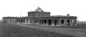
Haren Airport
Military airfield and civil airport in Belgium
Distance: Approx. 1265 meters
Latitude and longitude: 50.88027778,4.41916667
Haren Airport or Evere Airfield is a former military airfield and civil airport in Brussels, Belgium. Located in Brussels' city section of Haren and adjacent municipality of Evere, it was established by the German Empire in 1914 and lasted until the early 1950s when it was closed. Meanwhile it had been replaced by nearby Melsbroek airfield that Nazi Germany had established in World War II, which developed into the current Brussels Airport.
Royal Kituro Rugby Club
Rugby team
Distance: Approx. 1644 meters
Latitude and longitude: 50.86055556,4.39722222
The Royal Kituro Avia Schaerbeek Rugby Club, often shortened Kituro RC, is a Belgian rugby union club currently competing in the Belgian Elite League. On 8th February 2015, they beat RC Soignies 356-3, breaking the all-time record for the highest scoring game in Rugby union history. The club is based in Schaerbeek, a suburb to Brussels.
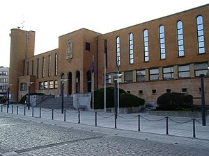
NATO Standardization Office
NATO agency responsible for standardization activities
Distance: Approx. 1317 meters
Latitude and longitude: 50.87615556,4.42201111
The NATO Standardization Office (NSO) (former NATO Standardization Agency, NSA; French: Bureau OTAN de normalisation) is a NATO agency created in 1951 to handle standardization activities for NATO. The NSA was formed through the merger of the Military Agency for Standardization and the Office for NATO Standardization. During the Agency Reforms, the NSA was transformed to the NATO Standardization Office (NSO) on 1 July 2014, headed by the Director of the NATO Standardization Office (DNSO). The NSO is composed of military and civilian staff that was created to be responsible for standardization for both the Military Committee and the North Atlantic Council It also provides standardization to NATO members military forces, with the goal of interoperability between member nations.

Confédération Interalliée des Sous-Officiers de Réserve
Distance: Approx. 1317 meters
Latitude and longitude: 50.87615556,4.42201111
The Confédération Interalliée des Sous-Officiers de Réserve (CISOR), until 2013 also known as Association Européenne des Sous-Officiers de Réserve (AESOR), is the parent organisation of the national European NCO Reserve Corps within the NATO and also international. Currently CISOR consists 14 countries under the presidential lead of Germany. This non-profit organisation was founded 1 June 1963.
Josaphat Brownfield
Former rail marshalling yard in Brussels, Belgium
Distance: Approx. 1497 meters
Latitude and longitude: 50.86222222,4.39583333
The Josaphat Brownfield (formerly the Schaerbeek Josaphat marshalling yard) is a 25 ha (62-acre) piece of land located between Schaerbeek and Evere in Brussels. Once a marshalling yard between the Meiser railway station and the Evere railway station linking Schaerbeek and Halle, the brownfield has since developed into a biodiversity haven in the heart of the European Union's capital.
Weather in this IP's area
clear sky
17 Celsius
17 Celsius
16 Celsius
18 Celsius
1009 hPa
88 %
1009 hPa
1003 hPa
10000 meters
4.63 m/s
210 degree
07:07:27
20:12:51