Country:
 Belgium
Region:
City:
Latitude and Longitude:
Time Zone:
Postal Code:
IP information under different IP Channel
ip-api
Country
Region
City
ASN
Time Zone
ISP
Blacklist
Proxy
Latitude
Longitude
Postal
Route
IPinfo
Country
Region
City
ASN
Time Zone
ISP
Blacklist
Proxy
Latitude
Longitude
Postal
Route
MaxMind
Country
Region
City
ASN
Time Zone
ISP
Blacklist
Proxy
Latitude
Longitude
Postal
Route
Luminati
Country
BERegion
bru
City
brussels
ASN
Time Zone
Europe/Brussels
ISP
Edgoo Networks Unipessoal Lda
Latitude
Longitude
Postal
db-ip
Country
Region
City
ASN
Time Zone
ISP
Blacklist
Proxy
Latitude
Longitude
Postal
Route
ipdata
Country
Region
City
ASN
Time Zone
ISP
Blacklist
Proxy
Latitude
Longitude
Postal
Route
Popular places and events near this IP address

Sainte-Catherine metro station
Metro station in Brussels, Belgium
Distance: Approx. 142 meters
Latitude and longitude: 50.85222222,4.34777778
Sainte-Catherine (French) or Sint-Katelijne (Dutch) is a Brussels Metro station on lines 1 and 5. It is located under the Place Sainte-Catherine/Sint-Katelijneplein, between the Quai aux Briques/Baksteenkaai and the Quai au Bois à Brûler/Brandhoutkaai, in the City of Brussels, Belgium. The station received its name from the aboveground Saint Catherine's Church, itself named after Saint Catherine.

Manstein plan
War plan of the German Army during the Battle of France in 1940
Distance: Approx. 433 meters
Latitude and longitude: 50.85,4.35
The Manstein plan or Case Yellow (German: Fall Gelb; also known after the war as Unternehmen Sichelschnitt a transliteration of the English Operation Sickle Cut), was the war plan of the German armed forces (Wehrmacht) for the Battle of France in 1940. The original invasion plan was an awkward compromise devised by General Franz Halder, the chief of staff of Oberkommando des Heeres (OKH, Army High Command) that satisfied no one. Documents with details of the plan fell into Belgian hands during the Mechelen incident on 10 January 1940 and the plan was revised several times, each giving more emphasis to an attack by Army Group A through the Ardennes, which progressively reduced the offensive by Army Group B through the Low Countries to a diversion.
Opéra du Quai au Foin
Distance: Approx. 251 meters
Latitude and longitude: 50.8553,4.34893056
The Opéra du Quai au Foin was the first public theatre in Brussels. Opened on 24 January 1682, it was abandoned in 1697 and turned into a warehouse.

Saint John the Baptist at the Béguinage
Church in Brussels, Belgium
Distance: Approx. 256 meters
Latitude and longitude: 50.85270278,4.35046667
The Church of St. John the Baptist at the Béguinage (French: Église Saint-Jean-Baptiste au Béguinage; Dutch: Sint-Jan-Baptist ten Begijnhofkerk) is a Roman Catholic parish church in central Brussels, Belgium. It is dedicated to Saint John the Baptist.

Brussels massacre
1370 killing of Jews in Brussels, present-day Belgium
Distance: Approx. 433 meters
Latitude and longitude: 50.85,4.35
The Brussels massacre was an anti-Semitic episode in Brussels (then within the Duchy of Brabant) in 1370 in connection with an alleged host desecration at the Brussels synagogue. A number of Jews, variously given as six or about twenty, were executed or otherwise killed, while the rest of the small community was banished. The event occurred on May 22.

Brussels Canal
Canal in Brussels, Belgium
Distance: Approx. 365 meters
Latitude and longitude: 50.85416667,4.34194444
The Brussels Canal (French: Canal de Bruxelles; Dutch: Kanaal van Brussel) is a section of waterway in Brussels, Belgium. It generally refers to the northernmost portion of the Brussels–Charleroi Canal (from the Ninove Gate to the Sainctelette area) and the southernmost section of the Brussels–Scheldt Maritime Canal or Willebroek Canal (between Sainctelette and the Vergote Dock). The Brussels Canal divides the City of Brussels from the municipality of Molenbeek-Saint-Jean, forming the border between them.
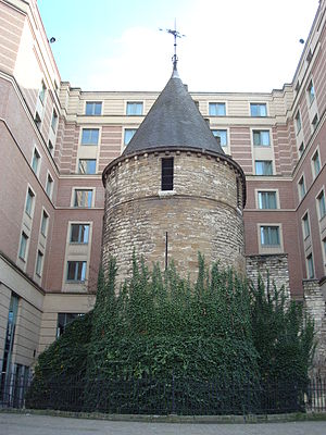
Black Tower (Brussels)
Medieval tower in Brussels, Belgium
Distance: Approx. 344 meters
Latitude and longitude: 50.85083333,4.34972222
The Black Tower (French: Tour Noire; Dutch: Zwarte Toren) is a medieval tower in central Brussels, Belgium. It is one of the best preserved remains of the first fortifications of Brussels, built at the start of the 13th century. It is notable for being a single medieval tower surrounded by modern-day buildings.

Royal Flemish Theatre
Theatre in Brussels, Belgium
Distance: Approx. 357 meters
Latitude and longitude: 50.85527778,4.35111111
The Royal Flemish Theatre (Dutch: Koninklijke Vlaamse Schouwburg, abbreviated KVS; French: Théâtre royal flamand) is a theatre in central Brussels, Belgium. It is the anchor of the Flemish theatre company in Brussels, which aims to promote professional theatre in the Dutch language in Belgium and abroad. A place is also made for dance, poetry, music and temporary exhibitions.

Anspach Fountain
Monumental fountain in Brussels, Belgium
Distance: Approx. 24 meters
Latitude and longitude: 50.85361111,4.34694444
The Anspach Fountain (French: Fontaine Anspach; Dutch: Anspachfontein) is an eclectic-style fountain-obelisk erected between 1895 and 1897 in the centre of the Place de Brouckère/De Brouckèreplein in Brussels, Belgium. Designed by the architect Charles-Émile Janlet, it is dedicated to the memory of Jules Anspach, a former mayor of the City of Brussels. The monument was dismantled in 1973 following construction work on the Brussels Metro.

Saint Catherine's Church, Brussels
Church in Brussels, Belgium
Distance: Approx. 307 meters
Latitude and longitude: 50.85083333,4.34861111
Saint Catherine's Church (French: Église Sainte-Catherine; Dutch: Sint-Katelijnekerk) is a Roman Catholic parish church in Brussels, Belgium. It is dedicated to Saint Catherine. The current church was designed by the architect Joseph Poelaert and built between 1854 and 1874 on the site of a basin of the former Port of Brussels, replacing an older church dating back to the 15th century.
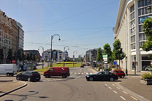
Square Sainctelette
Square in Brussels, Belgium
Distance: Approx. 240 meters
Latitude and longitude: 50.85555556,4.34694444
The Square Sainctelette (Dutch: Sainctelettesquare) is a square located in the City of Brussels municipality of Brussels, Belgium. It lies along the Brussels–Charleroi Canal, on the border with the Molenbeek-Saint-Jean municipality, from which it is separated by the canal. It is named in honour of Charles-Xavier Sainctelette, a former Belgian minister for public works.

Flanders Gate
Former city gate in Brussels, Belgium
Distance: Approx. 377 meters
Latitude and longitude: 50.85305556,4.34166667
The Flanders Gate (French: Porte de Flandre; Dutch: Vlaamsepoort) was one of the medieval city gates of the second walls of Brussels, Belgium.
Weather in this IP's area
clear sky
13 Celsius
13 Celsius
13 Celsius
15 Celsius
1027 hPa
87 %
1027 hPa
1025 hPa
10000 meters
2.57 m/s
10 degree
07:21:32
19:52:40