193.106.219.91 - IP Lookup: Free IP Address Lookup, Postal Code Lookup, IP Location Lookup, IP ASN, Public IP
Country:
Region:
City:
Location:
Time Zone:
Postal Code:
ISP:
ASN:
language:
User-Agent:
Proxy IP:
Blacklist:
IP information under different IP Channel
ip-api
Country
Region
City
ASN
Time Zone
ISP
Blacklist
Proxy
Latitude
Longitude
Postal
Route
db-ip
Country
Region
City
ASN
Time Zone
ISP
Blacklist
Proxy
Latitude
Longitude
Postal
Route
IPinfo
Country
Region
City
ASN
Time Zone
ISP
Blacklist
Proxy
Latitude
Longitude
Postal
Route
IP2Location
193.106.219.91Country
Region
mazowieckie
City
radom
Time Zone
Europe/Warsaw
ISP
Language
User-Agent
Latitude
Longitude
Postal
ipdata
Country
Region
City
ASN
Time Zone
ISP
Blacklist
Proxy
Latitude
Longitude
Postal
Route
Popular places and events near this IP address

Radom
City in Masovian Voivodeship, Poland
Distance: Approx. 676 meters
Latitude and longitude: 51.40361111,21.15666667
Radom is a city in east-central Poland, located approximately 100 kilometres (62 miles) south of the capital, Warsaw. It is situated on the Mleczna River in the Masovian Voivodeship. Radom is the fifteenth-largest city in Poland and the second-largest in its province with a population of 196,918 (30.06.2023) For centuries, Radom was part of the Sandomierz Province of the Kingdom of Poland and the later Polish–Lithuanian Commonwealth.

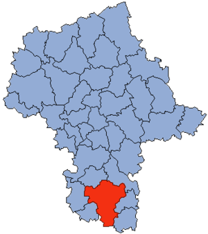
Radom Voivodeship
Former administrative division of Poland
Distance: Approx. 738 meters
Latitude and longitude: 51.404819,21.157054
Radom Voivodeship (Polish: województwo radomskie) was a unit of administrative division and local government in Poland in the years 1975–1998, superseded by Masovian Voivodeship. Its capital city was Radom.

Radom County
County in Masovian Voivodeship, Poland
Distance: Approx. 1387 meters
Latitude and longitude: 51.4,21.16666667
Radom County (Polish: powiat radomski) is a unit of territorial administration and local government (powiat) in Masovian Voivodeship, east-central Poland. It came into being on January 1, 1999, as a result of the Polish local government reforms passed in 1998. Its administrative seat is the city of Radom, although the city is not part of the county (it constitutes a separate city county).

Roman Catholic Diocese of Radom
Roman Catholic diocese in Poland
Distance: Approx. 880 meters
Latitude and longitude: 51.396944,21.156111
The Diocese of Radom (Latin: Dioecesis Radomensis) is a Latin Church diocese of the Catholic Church located in the city of Radom in the ecclesiastical province of Częstochowa in Poland.

University of Radom
Public university in Radom, Poland
Distance: Approx. 1387 meters
Latitude and longitude: 51.4,21.16666667
Kazimierz Pułaski University of Radom is a Polish public university in Radom. It was the biggest university of the former Radom Voivodeship. The university was established in 1950 as a School of Engineering of General Technical Organization.

Radom Główny railway station
Railway station in Radom, Poland
Distance: Approx. 1381 meters
Latitude and longitude: 51.39111111,21.155
Radom Główny, in English Radom Main, is the largest and the most centrally located railway station in Radom, Poland.

Radom Synagogue
Destroyed synagogue in Radom, Poland
Distance: Approx. 271 meters
Latitude and longitude: 51.40111111,21.14388889
The Radom Synagogue (Polish: Synagoga w Radomiu) was a former Orthodox Jewish congregation and synagogue, located on Podwalna Street, previously named Bożnicza Street, in Radom, in the Masovian Voivodeship of Poland.
Czachor Brothers Stadium
Distance: Approx. 677 meters
Latitude and longitude: 51.39644444,21.14622222
The Czachor Brothers Stadium (Polish: Stadion im. Braci Czachorów), also known as the Radom Municipal Stadium (Polish: Stadion Miejski w Radomiu), is located in Radom, Poland. It is currently used mostly for association football matches and is the home ground of Radomiak Radom.

Cathedral of the Protection of the Blessed Virgin Mary in Radom
Church in Radom, Poland
Distance: Approx. 890 meters
Latitude and longitude: 51.397,21.1564
The Cathedral of the Protection of the Blessed Virgin Mary in Radom (Polish: Katedra Opieki Najświętszej Maryi Panny w Radomiu) is a Catholic cathedral designed by Józef Pius Dziekoński (1844–1927), located on Henryka Sienkiewicza Street in Radom, Poland. The Radom Cathedral Museum contains a significant 14th century sculpture of the Madonna with Child. The sculpture was originally a fixture on the Radom city gates.

Bernardine Monastery Complex
Monastery in Radom, Poland
Distance: Approx. 126 meters
Latitude and longitude: 51.4014,21.1475
The Bernardine Monastery Complex (Polish: zespół klasztorny Bernardynów) is a Cistercian monastery in Radom, Poland. It is listed as a Historic Monument of Poland. Founded by King Casimir Jagiellon, the monastery has attracted the support of townspeople and nobility for centuries.
Piotrówka Hill Fort
Piotrówka hillfort in Radom Poland
Distance: Approx. 1003 meters
Latitude and longitude: 51.39988889,21.13327778
The Piotrówka Hillfort is a medieval hillfort located near Radom, Poland. It is one of the earliest elements of Radom's history and is a protected monument in Poland. The site is notable for its archeological significance including a coin hoard.

Church of St. John the Baptist, Radom
Church in Radom, Poland
Distance: Approx. 187 meters
Latitude and longitude: 51.40222222,21.14444444
The Church of St. John the Baptist is a gothic church in Radom, Poland. It was founded in the 14th century and is listed as a protected monument in Poland.
Weather in this IP's area
overcast clouds
3 Celsius
-2 Celsius
3 Celsius
3 Celsius
1036 hPa
94 %
1036 hPa
1015 hPa
10000 meters
5.52 m/s
11.39 m/s
280 degree
100 %
