193.106.185.144 - IP Lookup: Free IP Address Lookup, Postal Code Lookup, IP Location Lookup, IP ASN, Public IP
Country:
 Ukraine
Region:
City:
Location:
Time Zone:
Postal Code:
ISP:
ASN:
language:
User-Agent:
Proxy IP:
Blacklist:
IP information under different IP Channel
ip-api
Country
Region
City
ASN
Time Zone
ISP
Blacklist
Proxy
Latitude
Longitude
Postal
Route
db-ip
Country
Region
City
ASN
Time Zone
ISP
Blacklist
Proxy
Latitude
Longitude
Postal
Route
IPinfo
Country
Region
City
ASN
Time Zone
ISP
Blacklist
Proxy
Latitude
Longitude
Postal
Route
IP2Location
193.106.185.144Country
uaRegion
avtonomna respublika krym
City
kerch
Time Zone
Europe/Simferopol
ISP
Language
User-Agent
Latitude
Longitude
Postal
ipdata
Country
Region
City
ASN
Time Zone
ISP
Blacklist
Proxy
Latitude
Longitude
Postal
Route
Popular places and events near this IP address

Kerch
City in Crimea
Distance: Approx. 144 meters
Latitude and longitude: 45.36194444,36.47111111
Kerch, also known as Keriç or Kerich (Crimean Tatar: Keriç, Керич), is a city of regional significance on the Kerch Peninsula in the east of Crimea. It has a population of 147,033 (2014 Census). Founded 2,600 years ago as the ancient Greek colony Pantikapaion, Kerch is one of the most ancient cities in Crimea.
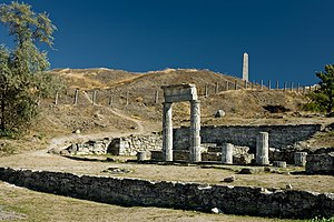
Pantikapaion
Ancient Greek city in Crimea
Distance: Approx. 1109 meters
Latitude and longitude: 45.35083333,36.46861111
Pantikapaion (Ancient Greek: Παντικάπαιον Pantikapaion, from Scythian *Pantikapa 'fish-path'; Latin: Panticapaeum) was an ancient Greek city on the eastern shore of Crimea, which the Greeks called Taurica. The city lay on the western side of the Cimmerian Bosporus, and was founded by Milesians in the late 7th or early 6th century BC, on a hill later named Mount Mithridat. Its ruins now lie in the modern city of Kerch.

Myrmēkion
Ancient Greek colony in Crimea
Distance: Approx. 4133 meters
Latitude and longitude: 45.3534,36.5224
Myrmēkion or Myrmecium (Ancient Greek: Μυρμήκιον, Russian: Мирмекий) was an ancient Greek colony in the Crimea. The settlement was founded in the eastern part of the modern city Kerch, 4 km NE of ancient Panticapaeum on the bank of the Kerch bay near the cape Karantinny. The settlement was founded by Milesians in the first half of the 6th c.

Mount Mithridat
Geographic feature in Crimea
Distance: Approx. 1114 meters
Latitude and longitude: 45.3507,36.4701
Mount Mithridat is a large hill located in the center of Kerch, a city on the eastern Kerch Peninsula of Crimea. It is 91.4 metres (300 ft) in elevation. From the top of Mount Mithridat a scenic view spreads across the Strait of Kerch and the city of Kerch.

Royal Kurgan
Kurgan in eastern Crimea, Ukraine
Distance: Approx. 4575 meters
Latitude and longitude: 45.3739,36.526
The Royal Kurgan or Tsarskyi Kurgan (Ukrainian: Царський курган) from the 4th century BC, is one of the most impressive tumuli (kurgans) of the eastern Crimea. The burial barrow is located in present-day Kerch (Ukraine), which developed out of the ancient Greek town of Pantikapaion (Παντικάπαιον) founded by Miletus.

Kerch Bay
Distance: Approx. 3052 meters
Latitude and longitude: 45.34361111,36.50111111
Kerch Bay (Russian: Керченская бухта, Ukrainian: Керченська бухта, Crimean Tatar: Keriç körfezi, Керич корьфези) is a bay of the Sea of Azov and Strait of Kerch in the eastern Crimea region. It is located at the eastern Kerch Peninsula, near the municipality of Kerch.

Port of Kerch
Port in Crimea
Distance: Approx. 1065 meters
Latitude and longitude: 45.35861111,36.48388889
Kerch Marine Trade Seaport (Russian: Керченский морской торговый порт, Ukrainian: Керченський морський торговельний порт) is one of the oldest ports of Black Sea (and Sea of Azov) located in the city of Kerch on the eastern shores of Kerch peninsula at Kerch Bay. The port has 10 piers.

Kerch Fishing Port
Port in Crimea
Distance: Approx. 2620 meters
Latitude and longitude: 45.33830556,36.46027778
Kerch Fishing Seaport (Russian: Керченский рыбный порт, Ukrainian: Керченський морський рибний порт) is a fishing port of Black Sea (and Sea of Azov) located in the city of Kerch on the eastern shores Kerch peninsula at Kerch Bay just south of the Port of Kerch. The port has 7 piers.

Church of Saint John the Baptist, Kerch
Historic site in Kerch
Distance: Approx. 1114 meters
Latitude and longitude: 45.35138889,36.47583333
The Church of St John the Baptist (also known as Church of St John the Precursor) is a Christian church located in the city center of Kerch, Crimea. Built in the Byzantine architectural style, it is noted for the candy-striping in its façade. Dating to 717 AD, it is said to be one of the oldest churches in Eastern Europe.

Kerch railway station
Railway station in Kerch, Crimea
Distance: Approx. 3382 meters
Latitude and longitude: 45.3631,36.4275
Kerch Railway station (Russian: Керчь, Ukrainian: Керч, Crimean Tatar: Keriç) is the main railway station of Kerch in Crimea, a territory recognized by a majority of countries as part of Ukraine, but de facto under control and administration of Russia.

Kerch Polytechnic College massacre
2018 school massacre in Kerch, Crimea
Distance: Approx. 5103 meters
Latitude and longitude: 45.35638889,36.53555556
The Kerch Polytechnic College massacre was a school shooting and bomb attack that occurred in Kerch, Crimea, on 17 October 2018, when 18-year-old student Vladislav Roslyakov killed 20 people and wounded 67 others before subsequently committing suicide. It was the deadliest school shooting in Russia or Ukraine since the 2004 Beslan school siege.
Yehorove
Village in Lenine Raion, Crimea
Distance: Approx. 3057 meters
Latitude and longitude: 45.38666667,36.48333333
Yehorove (Ukrainian: Єгорове; Russian: Его́рово, romanized: Yegorovo; Crimean Tatar: Yegorovo) is a village in Lenine Raion, Crimea. According to the 2001 Ukrainian census, the native languages of the inhabitants of the village were 89.29% Russian, 8.93% Ukrainian, and 1.79% Belarusian. On 18 March 1948, by an edict of the Presidium of the Supreme Soviet of the Russian SFSR, the settlement, formerly known as the collective farm Sakko i Vantsetti, was given its current name Yehorove.
Weather in this IP's area
clear sky
4 Celsius
1 Celsius
4 Celsius
4 Celsius
1026 hPa
73 %
1026 hPa
1024 hPa
10000 meters
3.42 m/s
3.88 m/s
339 degree
5 %