Country:
Region:
City:
Latitude and Longitude:
Time Zone:
Postal Code:
IP information under different IP Channel
ip-api
Country
Region
City
ASN
Time Zone
ISP
Blacklist
Proxy
Latitude
Longitude
Postal
Route
Luminati
Country
ASN
Time Zone
Europe/Istanbul
ISP
Pegasus Hava Tasimaciligi A.S.
Latitude
Longitude
Postal
IPinfo
Country
Region
City
ASN
Time Zone
ISP
Blacklist
Proxy
Latitude
Longitude
Postal
Route
db-ip
Country
Region
City
ASN
Time Zone
ISP
Blacklist
Proxy
Latitude
Longitude
Postal
Route
ipdata
Country
Region
City
ASN
Time Zone
ISP
Blacklist
Proxy
Latitude
Longitude
Postal
Route
Popular places and events near this IP address

Sultanbeyli
District in Istanbul, Turkey
Distance: Approx. 5733 meters
Latitude and longitude: 40.96833333,29.26166667
Sultanbeyli (pronounced [sulˈtanbejli]) is a municipality and district of Istanbul Province, Turkey. Its area is 29 km2, and its population is 358,201 (2022). It is located inland on the Asian side (Anadolu Yakasi) of the city.

Aydos Hill
Distance: Approx. 4393 meters
Latitude and longitude: 40.93166667,29.25472222
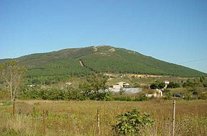
Aydos Hill (Turkish: Aydos Tepesi) is a hill in the north of Kartal district of Istanbul, Turkey. Its peak at 537 m (1,762 ft) above sea level is the highest point of Istanbul. The hill is surrounded by woods.

Sabiha Gökçen International Airport
Secondary airport serving Istanbul, Turkey
Distance: Approx. 3508 meters
Latitude and longitude: 40.89833333,29.30916667
Istanbul Sabiha Gökçen International Airport (IATA: SAW, ICAO: LTFJ) is an international airport serving Istanbul, Turkey. Located 32 km (20 mi) southeast of the city center, Sabiha Gökçen Airport is in the Asian part of the transcontinental city and serves as the operating base for AJet and Pegasus Airlines. The airport is named after Sabiha Gökçen, adoptive daughter of Mustafa Kemal Atatürk and the first female fighter pilot in the world.

Kurtköy High School
Public, anatolian high school in Kurtköy, Pendik, İstanbul, Turkey
Distance: Approx. 2051 meters
Latitude and longitude: 40.913119,29.296535
Kurtköy High School (Turkish: Kurtköy Anadolu Lisesi) is a secondary public anatolian school located in Pendik, Istanbul, Turkey.

2015 Sabiha Gökçen Airport bombing
Terrorist attack in Istanbul, Turkey
Distance: Approx. 3508 meters
Latitude and longitude: 40.89833333,29.30916667
The Sabiha Gökçen Airport bombing took place on 23 December 2015 in the apron area of Sabiha Gökçen International Airport in Istanbul, Turkey. The explosion, which occurred at approximately 02:05 local time, wounded two airport cleaners, one of whom later died after being taken to hospital. Flights from the terminal resumed as normal while Binali Yıldırım, the Minister of Transport, Maritime and Communication, claimed that there had been no security lapses at the airport.
Yakacık Çarşı
Neighbourhood in Kartal, Istanbul, Turkey
Distance: Approx. 7277 meters
Latitude and longitude: 40.91638889,29.22222222
Yakacık Çarşı is a neighbourhood in the municipality and district of Kartal, Istanbul Province, Turkey. Its population is 17,825 (2022).

Pegasus Airlines Flight 2193
February 2020 runway overrun incident in Istanbul, Turkey
Distance: Approx. 3165 meters
Latitude and longitude: 40.9055063,29.3264491
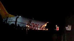
Pegasus Airlines Flight 2193 was a scheduled domestic passenger flight from Izmir to Istanbul in Turkey operated by Pegasus Airlines. On 5 February 2020, the Boeing 737-800 operating the route skidded off the runway while landing at Istanbul-Sabiha Gökçen International Airport, Turkey. Three people were killed, 179 people were injured, and the aircraft was destroyed.

Kurtköy, Pendik
Neighbourhood in Pendik, Istanbul, Turkey
Distance: Approx. 1858 meters
Latitude and longitude: 40.91416667,29.29916667
Kurtköy is a neighbourhood in the municipality and district of Pendik, Istanbul Province, Turkey. Its population is 37,801 (2022). Before 1987, when the district of Pendik was established, it was a neighbourhood of Kartal.

Fevzi Çakmak–Hastane (Istanbul Metro)
Station of the Istanbul Metro
Distance: Approx. 5866 meters
Latitude and longitude: 40.889167,29.2625
Fevzi Çakmak-Hastane is an underground rapid transit station on the M4 line of the Istanbul Metro. It is located at the intersection of Mimar Sinan Street and Ankara Street in the Fevzi Çakmak neighborhood of Pendik. It was opened on 2 October 2022 with the extension of M4 line from Tavşantepe to Sabiha Gökçen Airport.

Yayalar–Şeyhli (Istanbul Metro)
Station of the Istanbul Metro
Distance: Approx. 3892 meters
Latitude and longitude: 40.903889,29.275833
Yayalar-Şeyhli is an underground rapid transit station on the M4 line of the Istanbul Metro. It is located on Ankara Street in the Yayalar neighborhood of Pendik. It was opened on 2 October 2022 with the extension of M4 line from Tavşantepe to Sabiha Gökçen Airport.

Sabiha Gökçen Havalimanı (Istanbul Metro)
Station of the Istanbul Metro
Distance: Approx. 2610 meters
Latitude and longitude: 40.906667,29.311944
Sabiha Gökçen Havalimanı (Sabiha Gökçen Airport) is an underground rapid transit station on the M4 line of the Istanbul Metro. It is located in the Sanayi neighborhood of Pendik, serving Sabiha Gökçen International Airport. It was opened on 2 October 2022 with the extension of M4 line from Tavşantepe, and is the eastern terminus of the line.

Kurtköy (Istanbul Metro)
Station of the Istanbul Metro
Distance: Approx. 2441 meters
Latitude and longitude: 40.909444,29.296111
Kurtköy is an underground rapid transit station on the M4 line of the Istanbul Metro. It is located on Ankara Street in the Kurtköy neighborhood of Pendik. It was opened on 2 October 2022 with the extension of M4 line from Tavşantepe to Sabiha Gökçen Airport.
Weather in this IP's area
few clouds
14 Celsius
13 Celsius
14 Celsius
14 Celsius
1028 hPa
72 %
1028 hPa
1014 hPa
10000 meters
7.2 m/s
50 degree
20 %
07:42:01
17:51:06