Country:
 Netherlands
Region:
City:
Latitude and Longitude:
Time Zone:
Postal Code:
IP information under different IP Channel
ip-api
Country
Region
City
ASN
Time Zone
ISP
Blacklist
Proxy
Latitude
Longitude
Postal
Route
IPinfo
Country
Region
City
ASN
Time Zone
ISP
Blacklist
Proxy
Latitude
Longitude
Postal
Route
MaxMind
Country
Region
City
ASN
Time Zone
ISP
Blacklist
Proxy
Latitude
Longitude
Postal
Route
Luminati
Country
NLASN
Time Zone
Europe/Amsterdam
ISP
BIT BV
Latitude
Longitude
Postal
db-ip
Country
Region
City
ASN
Time Zone
ISP
Blacklist
Proxy
Latitude
Longitude
Postal
Route
ipdata
Country
Region
City
ASN
Time Zone
ISP
Blacklist
Proxy
Latitude
Longitude
Postal
Route
Popular places and events near this IP address
Drechtsteden
Distance: Approx. 2950 meters
Latitude and longitude: 51.81666667,4.68333333
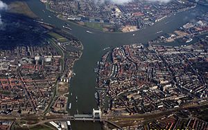
The Drechtsteden (Dutch pronunciation: [ˈdrɛxtsteːdə(n)]; Dutch for "Drecht cities") are a number of towns and cities bordering each other in the delta area of the rivers Oude Maas, Noord, and Beneden-Merwede in the province of South Holland, Netherlands. These cooperate in the Gemeenschappelijke Regeling Drechtsteden ("joint arrangement Drechtsteden"), which performs common tasks for the municipalities in the field of economy, development, culture, and social assistance. Collectively, a little more than 250,000 people call one of the towns and cities of Drechtsteden home.

Papendrecht
Municipality in South Holland, Netherlands
Distance: Approx. 2663 meters
Latitude and longitude: 51.83333333,4.68333333
Papendrecht (Dutch pronunciation: [ˈpaːpə(n)drɛxt] ) is a town and municipality in the western Netherlands, in the province of South Holland, at the crossing of the River Beneden Merwede and the Noord River. The municipality had a population of 32,171 in 2021 and covers an area of 10.79 km2 (4.17 sq mi) of which 1.38 km2 (0.53 sq mi) is water. Although Papendrecht is first mentioned in documents dating back to 1105, it remained a small settlement until the 1950s.

Sliedrecht
Municipality in South Holland, Netherlands
Distance: Approx. 3401 meters
Latitude and longitude: 51.81666667,4.76666667
Sliedrecht (Dutch pronunciation: [ˈslidrɛxt] ) is a town and municipality in the western Netherlands, in the province of South Holland. The municipality covers an area of 14.01 km2 (5.41 sq mi) of which 1.17 km2 (0.45 sq mi) is covered by water. Sliedrecht is known for the many large dredging companies (including Boskalis and IHC Merwede) that come from it.
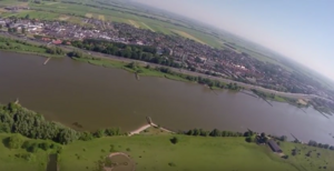
Beneden Merwede
Distance: Approx. 2954 meters
Latitude and longitude: 51.817,4.683
The Beneden Merwede (Dutch pronunciation: [bəˌneːdə ˈmɛrʋeːdə]; "Lower Merwede") is a stretch of river in the Netherlands, mainly fed by the river Rhine. It starts as the continuation of the Boven Merwede after the branching-off of the Nieuwe Merwede ship canal. It flows from Hardinxveld-Giessendam to Dordrecht, where it splits into the Noord and Oude Maas rivers.
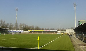
Stadion Krommedijk
Distance: Approx. 3681 meters
Latitude and longitude: 51.8025,4.68916667
The Stadion Krommedijk (known as the Matchoholic Stadion for sponsorship reasons) is a multi-purpose all-seater stadium in Dordrecht, South Holland, Netherlands. It is currently mostly used for football matches and is the home stadium of FC Dordrecht. The stadium is able to hold 4,100 spectators, and was built in 1948.

Wijngaarden
Village in South Holland, Netherlands
Distance: Approx. 3235 meters
Latitude and longitude: 51.84444444,4.76111111
Wijngaarden is a village in the Dutch province of South Holland. It is a part of the municipality of Molenlanden, and lies about 7 km northeast of Dordrecht. In 2001, the village of Wijngaarden had 300 inhabitants.

Johan's Ark
Reconstruction of Noah's Ark, Netherlands
Distance: Approx. 2725 meters
Latitude and longitude: 51.81912222,4.68506667
Johan's Ark is a Noah's Ark-themed barge in Dordrecht, Netherlands, which was built by the Dutch building contractor, carpenter and creationist Johan Huibers. It is a full-scale interpretation of the biblical Ark, featuring animal models, including cows, penguins, a crocodile, and a giraffe. It opened to the public in 2012.

Dordrecht Stadspolders railway station
Railway station in Dordrecht, Netherlands
Distance: Approx. 3018 meters
Latitude and longitude: 51.80194444,4.71666667
Dordrecht Stadspolders is a railway station in Dordrecht, Netherlands. The station is located on the MerwedeLingelijn between Dordrecht and Geldermalsen (part of the Elst–Dordrecht railway). It was opened on 27 May 1990 and initially had only one track.

Sliedrecht Baanhoek railway station
Railway station in the Netherlands
Distance: Approx. 1514 meters
Latitude and longitude: 51.82972222,4.74333333
Sliedrecht Baanhoek is a railway station, in Sliedrecht, Netherlands.
Matena, Netherlands
Village in South Holland, Netherlands
Distance: Approx. 715 meters
Latitude and longitude: 51.82805556,4.73166667
Matena is a small village in the west of the Netherlands. It is located in the municipality of Papendrecht, South Holland, east of the town Papendrecht.

Groothoofdspoort
City Gate in Dordrecht
Distance: Approx. 3670 meters
Latitude and longitude: 51.81944444,4.67027778
The Groothoofdspoort is a former city gate in Dordrecht that is located at the point where three rivers meet; the Merwede, the Oude Maas, and the Noord.

Binnenvaartmuseum
Maritime museum in Dordrecht, Netherlands
Distance: Approx. 2742 meters
Latitude and longitude: 51.8172,4.6863
Binnenvaartmuseum ('Inland Shipping Museum') is a floating museum in Dordrecht, South Holland, Netherlands, on the Wantij waterway near the former shipyard De Biesbosch.
Weather in this IP's area
moderate rain
15 Celsius
15 Celsius
14 Celsius
16 Celsius
998 hPa
87 %
998 hPa
998 hPa
10000 meters
1.34 m/s
4.47 m/s
73 degree
100 %
07:53:55
19:02:56