Country:
Region:
City:
Latitude and Longitude:
Time Zone:
Postal Code:
IP information under different IP Channel
ip-api
Country
Region
City
ASN
Time Zone
ISP
Blacklist
Proxy
Latitude
Longitude
Postal
Route
Luminati
Country
Region
hb
City
bremen
ASN
Time Zone
Europe/Berlin
ISP
Plusnet GmbH
Latitude
Longitude
Postal
IPinfo
Country
Region
City
ASN
Time Zone
ISP
Blacklist
Proxy
Latitude
Longitude
Postal
Route
db-ip
Country
Region
City
ASN
Time Zone
ISP
Blacklist
Proxy
Latitude
Longitude
Postal
Route
ipdata
Country
Region
City
ASN
Time Zone
ISP
Blacklist
Proxy
Latitude
Longitude
Postal
Route
Popular places and events near this IP address

AG Weser
Shipbuilding company
Distance: Approx. 1326 meters
Latitude and longitude: 53.1125,8.74861111
Aktien-Gesellschaft "Weser" (abbreviated A.G. "Weser") was one of the major German shipbuilding companies, located at the Weser River in Bremen. Founded in 1872 it was finally closed in 1983. All together, A.G. „Weser" built about 1,400 ships of different types, including many warships.

Wümme
River in Germany
Distance: Approx. 5436 meters
Latitude and longitude: 53.172,8.743
Wümme () is a river in northern Germany, in the states Lower Saxony and Bremen, marking the border between the two states for part of its course. It is the main headstream of the Lesum. The Wümme's length is 121 kilometres (75 mi).

Bundesautobahn 281
Federal motorway in Germany
Distance: Approx. 4727 meters
Latitude and longitude: 53.081765,8.724435
Bundesautobahn 281 (translates from German as Federal Motorway 281, short form Autobahn 281, abbreviated as BAB 281 or A 281) is an autobahn in Bremen in northwestern Germany. The first part was opened in 1995, parts near the Bremen Airport are currently under construction. A second Weser tunnel will be part of the project, presumably being financed as a toll road and built by a private contractor.

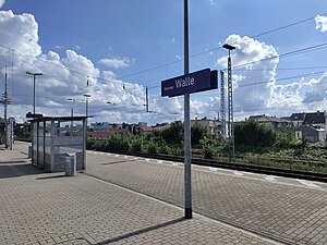
Bremen-Walle station
Railway station in Walle, Germany
Distance: Approx. 3719 meters
Latitude and longitude: 53.1043,8.7858
Bremen-Walle is a railway station in Bremen, Germany on the Bremen–Bremerhaven line. It is situated in the Walle district northwest of the city centre and the central station. The station only offers local services; it is a regular stop for the Verden to Bremen-Vegesack trains, with additional peak time services to and from Bremerhaven.

Bremen-Burg station
Railway station in Burglesum, Germany
Distance: Approx. 4694 meters
Latitude and longitude: 53.1597,8.7047
Bremen-Burg is a railway station serving the Burg district of Bremen. It also is a junction between the lines from Bremen–Bremerhaven and to Bremen-Vegesack. The station is connected to the BSAG bus network.

Bremen-Oslebshausen station
Railway station in Gröpelingen, Germany
Distance: Approx. 1348 meters
Latitude and longitude: 53.1353,8.7406
Bremen-Oslebshausen is a railway station located on the Vegesack-Bremen and Bremen-Bremerhaven railway lines. Only services on the Vegesack-Bremen line call at the station; services to and from Bremerhaven pass through without stopping.

Bremen TV tower
Distance: Approx. 4623 meters
Latitude and longitude: 53.09583333,8.79194444
Bremen-Walle Telecommunication Tower (official designation of Bremen TV tower), which is not accessible for the public, is, like the telecommunication tower at Münster and the Friedrich-Clemens-Gerke Tower in Cuxhaven, a reproduction of the telecommunication tower Kiel. It is 235.70 meters high. The diameter of the operating pulpit, which is 108.20 meters above ground, is 40 meters.

University of the Arts Bremen
Art school in Bremen, Germany
Distance: Approx. 3352 meters
Latitude and longitude: 53.09805556,8.7675
The University of the Arts Bremen (German: Hochschule für Künste Bremen, HfK Bremen) is a public university in Bremen, Germany. It is one of the most successful arts institutions, and its origins date back to 1873. The University of the Arts Bremen runs a Faculty of Fine Arts and Design, and a Faculty of Music, with approximately 900 students, 65 professors and about 180 assistant professors.

Blockland, Bremen
Distance: Approx. 4944 meters
Latitude and longitude: 53.14305556,8.80611111
Blockland is a landscape and nowadays a borough of Bremen, Germany. It is part of the Western municipal district and covers an area of 30.3 km2.

ArcelorMittal Bremen
Distance: Approx. 3401 meters
Latitude and longitude: 53.124,8.689
ArcelorMittal Bremen is a steelworks on the banks of the River Weser in Bremen, Germany. An ironworks was established on the site in 1911 as Norddeutsche Hütte - much of the works was destroyed or dismantled during and immediately after the end of the Second World War. In 1957 steel group Klöckner established a new steel works on the same site, Klöckner Hütte Bremen.
Die Küste (Bremen)
Former entertainment district in Bremen, Germany
Distance: Approx. 3725 meters
Latitude and longitude: 53.09801,8.7766
Die Küste (English: The Coast) was the former entertainment district at the Port of Bremen in Bremen, Germany. Die Küste evolved at the exit of the free port (Überseestadt) on the Nordstraße. It was linked to the Walle district by a foot tunnel, the Stinkbüdelmannsgang.
Missler concentration camp
Distance: Approx. 5332 meters
Latitude and longitude: 53.0935,8.8025
Missler concentration camp, also known as KZ Mißler in German, was an early concentration camp operating in Nazi Germany. The concentration camp was set up at the end of March 1933. Under orders of SS-Hauptsturmführer Otto Löblich, 148 prisoners, of which most were persecuted communists, were to be held in "protective custody".
Weather in this IP's area
broken clouds
9 Celsius
7 Celsius
8 Celsius
10 Celsius
1024 hPa
89 %
1024 hPa
1023 hPa
10000 meters
2.57 m/s
130 degree
75 %
07:31:05
16:46:10