Country:
 Denmark
Region:
City:
Latitude and Longitude:
Time Zone:
Postal Code:
IP information under different IP Channel
ip-api
Country
Region
City
ASN
Time Zone
ISP
Blacklist
Proxy
Latitude
Longitude
Postal
Route
IPinfo
Country
Region
City
ASN
Time Zone
ISP
Blacklist
Proxy
Latitude
Longitude
Postal
Route
MaxMind
Country
Region
City
ASN
Time Zone
ISP
Blacklist
Proxy
Latitude
Longitude
Postal
Route
Luminati
Country
 SE
SEASN
Time Zone
Europe/Stockholm
ISP
NORDUnet
Latitude
Longitude
Postal
db-ip
Country
Region
City
ASN
Time Zone
ISP
Blacklist
Proxy
Latitude
Longitude
Postal
Route
ipdata
Country
Region
City
ASN
Time Zone
ISP
Blacklist
Proxy
Latitude
Longitude
Postal
Route
Popular places and events near this IP address

Copenhagen
Capital and most populous city of Denmark
Distance: Approx. 2 meters
Latitude and longitude: 55.67611111,12.56833333
Copenhagen (Danish: København [kʰøpm̩ˈhɑwˀn] ) is the capital and most populous city of Denmark, with a population of 1.4 million in the urban area. The city is situated on the islands of Zealand and Amager, separated from Malmö, Sweden, by the Øresund strait. The Øresund Bridge connects the two cities by rail and road.
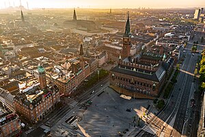
City Hall Square, Copenhagen
Central square in Copenhagen, Denmark
Distance: Approx. 62 meters
Latitude and longitude: 55.67583333,12.56916667
City Hall Square (Danish: Rådhuspladsen, pronounced [ˈʁʌðhusˌpʰlæsn̩]) is a public square in the centre of Copenhagen, Denmark, located in front of the Copenhagen City Hall. Its large size, central location, and affiliation with the city hall makes it a popular venue for a variety of events, celebrations and demonstrations. It is often used as a central point for measuring distances from Copenhagen.

Copenhagen Fire of 1728
Historic fire in Copenhagen, Denmark
Distance: Approx. 84 meters
Latitude and longitude: 55.6766,12.5693
The Copenhagen Fire of 1728 was the largest fire in the history of Copenhagen, Denmark. It began on the evening of 20 October 1728 and continued to burn until the morning of the 23rd of October 1728. It destroyed approximately 28% of the city (measured by counting the number of destroyed lots from the cadastre) and left 20% of the population homeless.
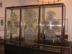
Jens Olsen's World Clock
Advanced astronomical clock
Distance: Approx. 94 meters
Latitude and longitude: 55.67555556,12.56944444
Jens Olsen's World Clock or Verdensur is an advanced astronomical clock which is displayed in Copenhagen City Hall. The clock was designed and calculated by Jens Olsen (1872–1945), who was a skilled locksmith, and later learned the trade of clockmaking. He also took part in the beginning of the clock's construction, and died in 1945, 10 years before the clock was completed.

Assault on Copenhagen (1659)
Part of the Second Northern War
Distance: Approx. 2 meters
Latitude and longitude: 55.67611111,12.56833333
The Assault on Copenhagen (Danish: Stormen på København) also known as the Battle of Copenhagen on 11 February 1659 was a major engagement during the Second Northern War, taking place during the Swedish siege of Copenhagen.
2000 UEFA Cup final riots
Football riots in City Hall Square, Copenhagen, Denmark (May 2000)
Distance: Approx. 62 meters
Latitude and longitude: 55.67583333,12.56916667
The 2000 UEFA Cup Final Riots, also known as the Battle of Copenhagen, were a series of riots in City Hall Square, Copenhagen, Denmark between fans of English football team Arsenal and Turkish team Galatasaray around the 2000 UEFA Cup Final on 17 May 2000. Four people were stabbed in the scuffles, which also involved fans from other clubs and were viewed by the media as part of a retaliation for the killing of two Leeds United fans by Galatasaray supporters the month before. The events of the day started early in the morning when skirmishes broke out in a bar, which led to an Arsenal fan being stabbed.
Timeline of Copenhagen
Distance: Approx. 2 meters
Latitude and longitude: 55.676111,12.568333
The following is a timeline of the history of the city of Copenhagen, Denmark.

Rådhuspladsen station
Railway station in Copenhagen Municipality, Denmark
Distance: Approx. 36 meters
Latitude and longitude: 55.6764,12.5681
Rådhuspladsen station (Danish pronunciation: [ˈʁʌðhusˌpʰlæsn̩], lit. City Hall Square) is an underground Copenhagen Metro station located on City Hall Square in central Copenhagen, Denmark. The station is on the City Circle Line (M3 and M4), between Gammel Strand and Copenhagen Central Station, and is in fare zone 1.

Dragon Fountain, Copenhagen
Fountain in Copenhagen, Denmark
Distance: Approx. 48 meters
Latitude and longitude: 55.6757,12.56858
The Dragon Fountain is a fountain located in the City Hall Square in Copenhagen, Denmark. It was designed by Joakim Skovgaard in collaboration with Thorvald Bindesbøll and features a bull in combat with a dragon.
Polar Bear with Cubs
Sculpture in Copenhagen, Denmark
Distance: Approx. 2 meters
Latitude and longitude: 55.67611111,12.56833333
Polar Bear With Cubs (Danish: Isbjørn med unger) is a sculpture situated at the southern end of the Langelinie Quay, just north of Langelinie Marina, in the Østerbro district of Copenhagen, Denmark.

Danish Royal Life Guards' Mutiny
Mutiny and revolt in copenhagen, 1771
Distance: Approx. 2 meters
Latitude and longitude: 55.67611111,12.56833333
The Royal Life Guards' Mutiny (Danish: Den kongelige livgardes Mytteri) also known as the Christmas Eve Feud (Danish: Julefejden) was an open revolt by the Danish Royal Life Guards against the decision of royal adviser, Johann Friedrich Struensee, to abolish the life guards in order to reform the Danish military.

Siege of Copenhagen (1368)
Siege and looting of Copenhagen by Hanseatic forces in 1368
Distance: Approx. 2 meters
Latitude and longitude: 55.67611111,12.56833333
The Siege of Copenhagen (Danish: Belejringen af København) or the Capture of Copenhagen (Danish: Overtagelsen af København), was a looting and siege of Copenhagen and Absalon's Castle in 1368 between Denmark and the Hanseatic League, during the Danish-Hanseatic War (1361–1370). The city was looted and Absalon's castle was destroyed.
Weather in this IP's area
clear sky
10 Celsius
9 Celsius
8 Celsius
11 Celsius
1010 hPa
72 %
1010 hPa
1009 hPa
10000 meters
5.01 m/s
7.34 m/s
155 degree
9 %
07:24:41
18:29:59