Country:
 Canada
Region:
City:
Latitude and Longitude:
Time Zone:
Postal Code:
IP information under different IP Channel
ip-api
Country
Region
City
ASN
Time Zone
ISP
Blacklist
Proxy
Latitude
Longitude
Postal
Route
IPinfo
Country
Region
City
ASN
Time Zone
ISP
Blacklist
Proxy
Latitude
Longitude
Postal
Route
MaxMind
Country
Region
City
ASN
Time Zone
ISP
Blacklist
Proxy
Latitude
Longitude
Postal
Route
Luminati
Country
CARegion
qc
City
montreal
ASN
Time Zone
America/Toronto
ISP
OVH SAS
Latitude
Longitude
Postal
db-ip
Country
Region
City
ASN
Time Zone
ISP
Blacklist
Proxy
Latitude
Longitude
Postal
Route
ipdata
Country
Region
City
ASN
Time Zone
ISP
Blacklist
Proxy
Latitude
Longitude
Postal
Route
Popular places and events near this IP address
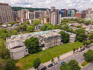
Canadian Centre for Architecture
Architecture museum and research centre in Quebec, Canada
Distance: Approx. 403 meters
Latitude and longitude: 45.491,-73.57855556
The Canadian Centre for Architecture (CCA; French: Centre Canadien d'Architecture) is a museum of architecture and research centre in Montreal, Quebec, Canada. It is located at 1920, rue Baile (1920, Baile Street), between rue Fort (Fort Street) and rue Saint-Marc (Saint-Marc Street) in what was once part of the Golden Square Mile. Today, it is considered to be located in the Shaughnessy Village neighbourhood of the borough of Ville-Marie.

Griffintown
Neighbourhood in Montreal, Quebec, Canada
Distance: Approx. 597 meters
Latitude and longitude: 45.48756,-73.56677
Griffintown is a historic neighbourhood of Montreal, Quebec, southwest of downtown. The area existed as a functional neighbourhood from the 1820s until the 1960s and was mainly populated by Irish immigrants and their descendants. Mostly depopulated since then, the neighbourhood has been undergoing redevelopment since the early 2010s.

Georges-Vanier station
Montreal Metro station
Distance: Approx. 213 meters
Latitude and longitude: 45.48888889,-73.57666667
Georges-Vanier station is a Montreal Metro station in the borough of Le Sud-Ouest in Montreal, Quebec, Canada. It is operated by the Société de transport de Montréal (STM) and serves the Orange Line. It is located in the Little Burgundy area.

Montreal Children's Hospital
Children's hospital in Quebec, Canada
Distance: Approx. 634 meters
Latitude and longitude: 45.48878,-73.582091
Montreal Children's Hospital (French: Hôpital de Montréal pour enfants) is a children's hospital in Montreal, Quebec, Canada. Founded in 1904, it is affiliated with the McGill University Health Centre (MUHC) and McGill University, Faculty of Medicine. The hospital has 154 single-patient rooms, 52-bed neonatology unit, 6 operating rooms and 6 intervention rooms.

LaSalle College
College in Montreal, Canada
Distance: Approx. 622 meters
Latitude and longitude: 45.49138889,-73.58138889
LaSalle College (French: Collège LaSalle) was founded in Montreal, in the province of Quebec, Canada, in 1959 by Jean-Paul Morin. The college offers over 60 programs DCS (pre-university and technical) and ACS programs. It is the largest bilingual college in North America, with 7 specialized schools: Art, Design and Communication, Business and Management, Education and Social Sciences, Fashion, Gaming, Animation and VFX, Hospitality and Tourism and Information Technology.
Saint-Louis (provincial electoral district)
Provincial electoral district in Quebec, Canada
Distance: Approx. 609 meters
Latitude and longitude: 45.494,-73.578
Saint-Louis was a provincial electoral district in the Montreal region of Quebec, Canada. It corresponded to the western half of Ville-Marie (downtown Montreal). It was created for the 1966 election from parts of Montréal–Saint-Louis, Montréal-Outremont and Montréal-Mercier electoral districts.
Overdale
Neighbourhood in Montreal, Quebec, Canada
Distance: Approx. 624 meters
Latitude and longitude: 45.494872,-73.573122
Overdale was a small residential district in downtown Montreal that became a famous symbol of the struggle between urban conservationists and land developers. In the mid-1980s, two developers, Robert Landau and Douglas Cohen, operating under an array of names, including Les Galleria Dorchester and Grinch Realties, purchased a series of buildings in an area bounded by Overdale Avenue, Lucien L'Allier Street, Mackay Street and Dorchester Boulevard (Dorchester was renamed as René Lévesque Boulevard in 1987). The developers proposed to demolish all of the homes and replace them with a large condo project.

Little Burgundy
Neighbourhood in Montreal, Quebec, Canada
Distance: Approx. 480 meters
Latitude and longitude: 45.485209,-73.575954
Little Burgundy (French: La Petite-Bourgogne) is a neighbourhood in the South West borough of the city of Montreal, Quebec, Canada.
Mel Hoppenheim School of Cinema
Film school of Concordia University in Montreal, Canada
Distance: Approx. 634 meters
Latitude and longitude: 45.49444444,-73.5775
The Mel Hoppenheim School of Cinema, a division of the Faculty of Fine Arts at Concordia University, is a film school located in Montreal, Quebec. Informally known as MHSoC, the school accepts around 250 students a year for programs in animation, film production and film studies. It is the largest and oldest university-based centre for the study of film, television and media in Canada.

Bank of Montreal National Historic Site
Distance: Approx. 446 meters
Latitude and longitude: 45.48781,-73.56869
Bank of Montreal National Historic Site is an historic former bank branch in Montreal. Built in 1894 in sandstone on the corners of rue Notre Dame Ouest and rue des Seigneurs, this building was named a National Historic Site of Canada in 1990 because: the building is a particularly good example of the Queen Anne Revival style, as expressed in commercial architecture... Built for the bank of the same name, the Bank of Montréal building is a rare surviving example of the Queen Anne Revival style applied to a commercial building.
Montefiore Club
Distance: Approx. 608 meters
Latitude and longitude: 45.494548,-73.57618
The Montefiore Club was a private members' club, catering to the Jewish community, located in Montreal, Quebec, Canada.
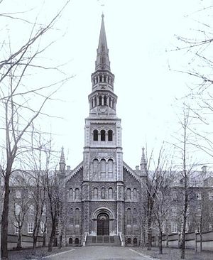
Grey Nuns Motherhouse
Historic site in Quebec, Canada
Distance: Approx. 507 meters
Latitude and longitude: 45.493445,-73.576701
Grey Nuns Motherhouse, now known as the Grey Nuns Building, is a former motherhouse of the Grey Nuns located at 1190 Guy Street, in the Borough of Ville-Marie, Montréal, Quebec, Canada. It is also named Grey Nuns Hospital of Montréal (not to be confused with Grey Nuns' Hospital located south of Place d'Youville). The building was completed in 1871.
Weather in this IP's area
broken clouds
16 Celsius
15 Celsius
15 Celsius
17 Celsius
1008 hPa
63 %
1008 hPa
1006 hPa
10000 meters
10.8 m/s
13.38 m/s
240 degree
75 %
07:00:32
18:23:08