192.96.244.34 - IP Lookup: Free IP Address Lookup, Postal Code Lookup, IP Location Lookup, IP ASN, Public IP
Country:
Region:
City:
Location:
Time Zone:
Postal Code:
ISP:
ASN:
language:
User-Agent:
Proxy IP:
Blacklist:
IP information under different IP Channel
ip-api
Country
Region
City
ASN
Time Zone
ISP
Blacklist
Proxy
Latitude
Longitude
Postal
Route
db-ip
Country
Region
City
ASN
Time Zone
ISP
Blacklist
Proxy
Latitude
Longitude
Postal
Route
IPinfo
Country
Region
City
ASN
Time Zone
ISP
Blacklist
Proxy
Latitude
Longitude
Postal
Route
IP2Location
192.96.244.34Country
Region
california
City
los angeles
Time Zone
America/Los_Angeles
ISP
Language
User-Agent
Latitude
Longitude
Postal
ipdata
Country
Region
City
ASN
Time Zone
ISP
Blacklist
Proxy
Latitude
Longitude
Postal
Route
Popular places and events near this IP address

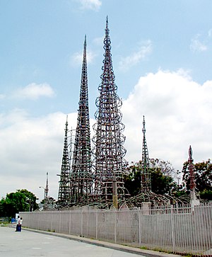
Watts Towers
Historic folk art site in Los Angeles, California
Distance: Approx. 798 meters
Latitude and longitude: 33.93873889,-118.24104722
The Watts Towers, Towers of Simon Rodia, or Nuestro Pueblo ("our town" in Spanish) are a collection of 17 interconnected sculptural towers, architectural structures, and individual sculptural features and mosaics within the site of the artist's original residential property in Watts, Los Angeles, California, United States. The entire site of towers, structures, sculptures, pavement and walls were designed and built solely by Sabato ("Simon" or "Sam") Rodia (1879 or 1886 to 1965), an Italian immigrant construction worker and tile mason, over a period of 33 years from 1921 to 1954. The tallest of the towers is 99.5 feet (30.3 m).
Charles R. Drew University of Medicine and Science
Private university in Willowbrook, California, US
Distance: Approx. 821 meters
Latitude and longitude: 33.925634,-118.242594
Charles R. Drew University of Medicine and Science is a private university in Willowbrook, California, focused on health sciences. It was founded in 1966 in response to inadequate medical access within the Watts region of Los Angeles, California. The university is named in honor of Charles R. Drew.

Nickerson Gardens
Public housing complex in Los Angeles, California, United States
Distance: Approx. 205 meters
Latitude and longitude: 33.93229,-118.24769
Nickerson Gardens is a 1,066-unit public housing apartment complex at 1590 East 114th Street in Watts, Los Angeles, California. Nickerson Gardens is the largest public housing development in Los Angeles.
Gonzaque Village
Public housing project in Watts, Los Angeles, California
Distance: Approx. 926 meters
Latitude and longitude: 33.94083333,-118.24694444
Gonzaque Village is public housing project located in the Watts neighborhood of Los Angeles, California. It is operated by the Housing Authority of the City of Los Angeles. It was built in 1942 on 17.6 acres (71,200 m2) of flat land.
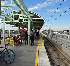
Willowbrook/Rosa Parks station
Los Angeles Metro Rail station
Distance: Approx. 848 meters
Latitude and longitude: 33.9282,-118.238
Willowbrook/Rosa Parks station (formerly Imperial/Wilmington/Rosa Parks station) is a major transport hub and Los Angeles Metro Rail station that serves the A and C lines. The station, located at the intersection of Imperial Highway and Wilmington Avenue in the Willowbrook community of Los Angeles County, is a major transfer point for commuters. As a major transfer station, Willowbrook/Rosa Parks station also acts as a major bus hub, serving many bus routes operated by Metro and other regional/municipal transit agencies.
Martin Luther King Jr. Outpatient Center
Hospital in California, United States
Distance: Approx. 1044 meters
Latitude and longitude: 33.9238,-118.2416
The Martin Luther King Jr. Outpatient Center, formerly known as Martin Luther King Jr. Multi-Service Ambulatory Care Center, Martin Luther King Jr./Drew Medical Center (King/Drew), and later Martin Luther King Jr.–Harbor Hospital (MLK–Harbor or King–Harbor), was a public urgent care center and outpatient clinic and former hospital in Willowbrook, an unincorporated section of Los Angeles County, California, north of the city of Compton and south of the Watts neighborhood of Los Angeles.
Verbum Dei Jesuit High School
School in Los Angeles, California, United States
Distance: Approx. 761 meters
Latitude and longitude: 33.93472222,-118.25333333
Verbum Dei Jesuit High School, nicknamed the Verb, is a private Catholic all-boys college preparatory school sponsored by the Society of Jesus in Los Angeles, California. It was founded in 1962 by the Society of the Divine Word to serve students from the Watts neighborhood and the surrounding communities who are economically and academically under-served. Verbum Dei is known for sending its graduates to some of the more selective colleges in the United States and has held a 100% success rate for sending graduating seniors to college.
King/Drew Magnet High School of Medicine and Science
Magnet school
Distance: Approx. 918 meters
Latitude and longitude: 33.924359,-118.245724
King/Drew Magnet High School of Medicine and Science is a magnet high school of the Los Angeles Unified School District, located in Willowbrook, unincorporated Los Angeles County, California, United States. It is affiliated with both the Martin Luther King Jr. Community Hospital and the Charles R. Drew University of Medicine and Science.

Rancho La Tajauta
Former Mexican land grant in present-day Los Angeles County, California, USA
Distance: Approx. 447 meters
Latitude and longitude: 33.92944444,-118.2425
Rancho Tajauta was a 3,560-acre (14.4 km2) Mexican land grant in present-day Los Angeles County, California given in 1843 by Governor Manuel Micheltorena to Anastasio Avila. The grant was named for the Gabrielino/Tongva place name of Tajáuta. The grant encompassed present-day Willowbrook and Watts.
Martin Luther King Jr. Community Hospital
Hospital in California, United States
Distance: Approx. 1056 meters
Latitude and longitude: 33.923229,-118.243737
Martin Luther King Jr. Community Hospital, also known as MLK-LA, is a 131-bed public community hospital in the unincorporated Willowbrook neighborhood of southern Los Angeles County, California, just outside of the Los Angeles city limits. It was planned and designed to especially serve the surrounding South Los Angeles communities' needs, including those of underinsured or uninsured patients.
The Barrelhouse
Nightclub in Los Angeles, California
Distance: Approx. 928 meters
Latitude and longitude: 33.939009,-118.239076
The Barrelhouse Club, at 107th and Wilmington in Watts, Los Angeles, was a rhythm and blues nightclub opened in 1948 and co-owned by Johnny Otis, and Bardu and Tila Ali. It was named in honour of the Barrel House in Omaha, Nebraska, the first club in that district to welcome black and white customers.
Hawkins House of Burgers
Hamburger restaurant in California
Distance: Approx. 728 meters
Latitude and longitude: 33.9293,-118.2523
Hawkins House of Burgers is a hamburger restaurant in the Watts neighborhood of Los Angeles, California. It traces its beginnings to 1939 and has seen many events, such as the Watts and 1992 Los Angeles riots. The restaurant "has come to represent a symbol of resilience in the community," according to Thrillist.
Weather in this IP's area
overcast clouds
9 Celsius
7 Celsius
8 Celsius
10 Celsius
1017 hPa
91 %
1017 hPa
1017 hPa
10000 meters
5.14 m/s
12.35 m/s
300 degree
100 %
