192.93.225.22 - IP Lookup: Free IP Address Lookup, Postal Code Lookup, IP Location Lookup, IP ASN, Public IP
Country:
Region:
City:
Location:
Time Zone:
Postal Code:
IP information under different IP Channel
ip-api
Country
Region
City
ASN
Time Zone
ISP
Blacklist
Proxy
Latitude
Longitude
Postal
Route
Luminati
Country
ASN
Time Zone
Europe/Paris
ISP
Celeste SAS
Latitude
Longitude
Postal
IPinfo
Country
Region
City
ASN
Time Zone
ISP
Blacklist
Proxy
Latitude
Longitude
Postal
Route
IP2Location
192.93.225.22Country
Region
ile-de-france
City
provins
Time Zone
Europe/Paris
ISP
Language
User-Agent
Latitude
Longitude
Postal
db-ip
Country
Region
City
ASN
Time Zone
ISP
Blacklist
Proxy
Latitude
Longitude
Postal
Route
ipdata
Country
Region
City
ASN
Time Zone
ISP
Blacklist
Proxy
Latitude
Longitude
Postal
Route
Popular places and events near this IP address
Provins
Subprefecture and commune in Île-de-France, France
Distance: Approx. 1193 meters
Latitude and longitude: 48.5604,3.299
Provins (French pronunciation: [pʁɔvɛ̃] ) is a commune in the Seine-et-Marne department in the Île-de-France region in north-central France. Known for its well-preserved medieval architecture and importance throughout the Middle Ages as an economic center and a host of annual trading fairs, Provins became a UNESCO World Heritage Site in 2001.

Poigny
Commune in Île-de-France, France
Distance: Approx. 1721 meters
Latitude and longitude: 48.5389,3.2833
Poigny (French pronunciation: [pwaɲi] ) is a commune in the Seine-et-Marne department in the Île-de-France region in north-central France. Champbenoist–Poigny station has rail connections to Provins, Longueville and Paris.

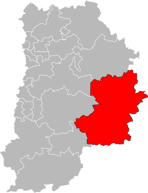
Arrondissement of Provins
Arrondissement in Île-de-France, France
Distance: Approx. 957 meters
Latitude and longitude: 48.55805556,3.29694444
The arrondissement of Provins is an arrondissement of France in the Seine-et-Marne department in the Île-de-France region. It has 174 communes. Its population is 186,339 (2021), and its area is 2,344.6 km2 (905.3 sq mi).

Canton of Provins
Canton in Île-de-France, France
Distance: Approx. 3587 meters
Latitude and longitude: 48.56055556,3.25416667
The canton of Provins is a French administrative division, located in the arrondissement of Provins, in the Seine-et-Marne département (Île-de-France région).

Chalautre-la-Petite
Commune in Île-de-France, France
Distance: Approx. 2637 meters
Latitude and longitude: 48.5281,3.3147
Chalautre-la-Petite (French pronunciation: [ʃalotʁ la pətit] ) is a commune in the Seine-et-Marne department in the Île-de-France region in north-central France.

Sourdun
Commune in Île-de-France, France
Distance: Approx. 3834 meters
Latitude and longitude: 48.5369,3.3483
Sourdun (French pronunciation: [suʁdœ̃] ) is a commune in the Seine-et-Marne department in the Île-de-France region in north-central France.

Saint-Brice, Seine-et-Marne
Commune in Île-de-France, France
Distance: Approx. 2889 meters
Latitude and longitude: 48.5678,3.3281
Saint-Brice (French pronunciation: [sɛ̃ bʁis] ) is a commune in the Seine-et-Marne department in the Île-de-France region in north-central France.

Sainte-Colombe, Seine-et-Marne
Commune in Île-de-France, France
Distance: Approx. 3064 meters
Latitude and longitude: 48.5364,3.2636
Sainte-Colombe (French pronunciation: [sɛ̃t kɔlɔ̃b] ) is a commune in the Seine-et-Marne department in the Île-de-France region in north-central France. Sainte-Colombe–Septveilles station has rail connections to Provins, Longueville and Paris.
Communauté de communes du Provinois
Federation of municipalities in France
Distance: Approx. 1147 meters
Latitude and longitude: 48.56,3.3
The Communauté de communes du Provinois is a federation of municipalities (communauté de communes) in the Seine-et-Marne département and in the Île-de-France région of France. Its seat is Provins. Its area is 628.5 km2, and its population was 34,587 in 2018, of which 12,000 in Provins.

Provins station
Railway station in Provins, France
Distance: Approx. 690 meters
Latitude and longitude: 48.55555556,3.30305556
Provins station (French: Gare de Provins) is a French railway station located in the commune of Provins, Seine-et-Marne department in the Île-de-France region. The station opened on 11 December 1858 and is located on the Longueville–Esternay railway line. The station is served by TER (local) services operated by SNCF: Transilien line P (Paris–Longueville–Provins).

Sainte-Colombe–Septveilles station
Railway station in Sainte-Colombe, France
Distance: Approx. 3926 meters
Latitude and longitude: 48.52972222,3.25611111
Sainte-Colombe–Septveilles station (French: Gare de Sainte-Colombe–Septveilles) is a railway station in Sainte-Colombe, Île-de-France, France.

Champbenoist–Poigny station
Railway station in Provins, Île-de-France, France
Distance: Approx. 1049 meters
Latitude and longitude: 48.54555556,3.28722222
Champbenoist–Poigny is a railway station in Poigny near Provins, Île-de-France, France. The station is on the Longueville–Esternay railway line. It is served by TER (local) services operated by SNCF. The station is served by Transilien line P (Paris–Verneuil-l'Étang–Longueville–Provins).
Weather in this IP's area
clear sky
2 Celsius
-1 Celsius
2 Celsius
2 Celsius
1024 hPa
92 %
1024 hPa
1010 hPa
10000 meters
3.01 m/s
7.18 m/s
288 degree
7 %
