Country:
 USA
USARegion:
City:
Latitude and Longitude:
Time Zone:
Postal Code:
IP information under different IP Channel
ip-api
Country
Region
City
ASN
Time Zone
ISP
Blacklist
Proxy
Latitude
Longitude
Postal
Route
IPinfo
Country
Region
City
ASN
Time Zone
ISP
Blacklist
Proxy
Latitude
Longitude
Postal
Route
MaxMind
Country
Region
City
ASN
Time Zone
ISP
Blacklist
Proxy
Latitude
Longitude
Postal
Route
Luminati
Country
USASN
Time Zone
America/Chicago
ISP
TDY-US1-DC
Latitude
Longitude
Postal
db-ip
Country
Region
City
ASN
Time Zone
ISP
Blacklist
Proxy
Latitude
Longitude
Postal
Route
ipdata
Country
Region
City
ASN
Time Zone
ISP
Blacklist
Proxy
Latitude
Longitude
Postal
Route
Popular places and events near this IP address
Newbury Park, California
Community in Ventura County, California, United States
Distance: Approx. 1105 meters
Latitude and longitude: 34.18417,-118.90972
Newbury Park is a populated place and town in Ventura County, California, United States. Most of it lies within the western Thousand Oaks city limits, while unincorporated areas include Casa Conejo and Ventu Park. The town is located in Southern California around 8 miles (13 km) from the Pacific Ocean and has a mild year-round climate, scenic mountains, and environmental preservation.

Conejo Valley Botanic Garden
Botanic garden in Thousand Oaks, California
Distance: Approx. 1771 meters
Latitude and longitude: 34.19194444,-118.88583333
Conejo Valley Botanic Garden is located in Thousand Oaks, California, and consists of a peak with vista views along with 15 hillside botanical gardens. It provides a teaching laboratory for what flora works and what does not work in the Conejo Valley. The 33-acre (13-hectare) site consists of a vast variety of endemic plants, water-conserving plants, oak trees, and indigenous wildlife.

Stagecoach Inn (California)
United States historic place
Distance: Approx. 1796 meters
Latitude and longitude: 34.17805556,-118.91138889
The Stagecoach Inn Museum in Newbury Park, California, originally known as the Grand Union Hotel, was used as a resting area for people who traveled from Los Angeles to Santa Barbara. Besides a hotel and stagecoach stop, it has also been used as a post office, church, restaurant and military school. It is California Historical Landmark No.

The Oaks (Thousand Oaks, California)
Regional shopping mall located in Thousand Oaks, California
Distance: Approx. 1851 meters
Latitude and longitude: 34.1843,-118.8881
The Oaks is a two-level indoor/outdoor, regional shopping mall located in Thousand Oaks, California. It is owned and managed by Macerich. Accessible from US Highway 101 (the Ventura Freeway) midway between downtown Los Angeles and Santa Barbara, it is the largest shopping center in Ventura County.
Rancho El Conejo
Mexican land grant in Ventura and Los Angeles Counties, California
Distance: Approx. 876 meters
Latitude and longitude: 34.2,-118.9
Rancho El Conejo was a 48,572-acre (196.56 km2) Spanish land grant in California given in 1803 to Jose Polanco and Ygnacio Rodriguez that encompassed the area now known as the Conejo Valley in southeastern Ventura and northwestern Los Angeles Counties. El Conejo is Spanish for "The Rabbit", and refers to the many rabbits common to the region (the desert cottontail and brush rabbit species). The east-west grant boundaries approximately went from the border of Westlake Village near Lindero Canyon Road in the east to the Conejo Grade (the top of the hill along the 101 Freeway looking down into Camarillo) in the west.

Rancho Conejo Playfields
Park in Newbury Park, California
Distance: Approx. 696 meters
Latitude and longitude: 34.19222222,-118.91244444
Rancho Conejo Playfields is a 13 acres (5.3 ha) multi-use community park in Newbury Park, California, adjacent to Conejo Canyons Open Space and the Arroyo Conejo Nature Preserve which includes 302 acres (122 ha) of public open-space land and numerous trails in the western Simi Hills.
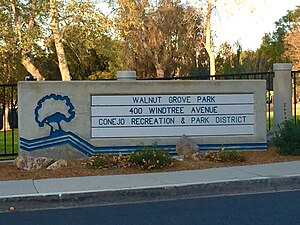
Walnut Grove Park
Community park in Newbury Park, California
Distance: Approx. 1218 meters
Latitude and longitude: 34.18397222,-118.89808333
Walnut Grove Park is a 6.5 acre community park in Newbury Park, California, United States, situated immediately south of the U.S. 101 Ventura Freeway on Newbury Road. Named for its many walnut trees, the park land was acquired in 1981 and ultimately developed into a community park in 1994. It contains a playground, an outdoor handball court, three BBQ grills, basketball courts, numerous picnic tables, trails, and open-space.

Lynn Oaks Park
Community park in Newbury Park, California, U.S.
Distance: Approx. 2058 meters
Latitude and longitude: 34.17491667,-118.90258333
Lynn Oaks Park is a seven-acre community park in the southern part of Newbury Park, California, which includes trails to numerous surrounding nature areas, including but not limited to the Hope Nature Preserve, Hidden Valley, and the Santa Monica Mountains National Recreation Area. It was first developed as a community park in 1983 and is named for its many oak trees. The park contains a volleyball court, outdoor basketball court, soccer field, a playground, barbecue grills, water fountains and numerous picnic tables.

Tarantula Hill
Peak in California
Distance: Approx. 1607 meters
Latitude and longitude: 34.1962,-118.8879
Tarantula Hill, is a 1,057-foot-high (322 m) peak in Thousand Oaks, California. It is located on a 45-acre (18 ha) open space and is operated by the Conejo Open Space Conservation Agency (COSCA). Climbing Tarantula Hill is a steep 0.5-mile (0.80 km) trail; the trailhead is located at 287 West Gainsborough Road, across the road from the main entrance to Conejo Valley Botanic Garden.

Ventu Park, California
Unincorporated area in Ventura County, California, United States
Distance: Approx. 1738 meters
Latitude and longitude: 34.17861111,-118.91138889
Ventu Park ( ) is an unincorporated community in southern Newbury Park, California. Unlike most of Newbury Park, Ventu Park is not within the Thousand Oaks city limits. It borders Ventu Park Open Space in the north, Hidden Valley in the south, and Hope Nature Preserve in the east.

Conejo Recreation and Park District
Park management agency in Thousand Oaks, California
Distance: Approx. 2020 meters
Latitude and longitude: 34.18666,-118.88459
Conejo Recreation and Park District (CRPD) is the park management agency for most of the parks in the Conejo Valley, California. Established in 1962, CRPD later established Conejo Open Space Conservation Agency (COSCA) in 1977 through a joint effort with the City of Thousand Oaks. COSCA administers over 15,000 acres of open space and 140 miles of trails, while CRPD administers over 50 community parks.

Timber School
Building in Newbury Park, CA
Distance: Approx. 1784 meters
Latitude and longitude: 34.18375,-118.92055556
Timber School was the first school in Newbury Park, California when established in 1889. and the current 1924 reconstructed Timber School is the oldest remaining school in the City of Thousand Oaks. It is also the oldest remaining public building in the Conejo Valley.
Weather in this IP's area
few clouds
21 Celsius
21 Celsius
19 Celsius
23 Celsius
1011 hPa
52 %
1011 hPa
988 hPa
10000 meters
9.26 m/s
260 degree
20 %
06:39:57
19:00:46