Country:
 Netherlands
Region:
City:
Latitude and Longitude:
Time Zone:
Postal Code:
IP information under different IP Channel
ip-api
Country
Region
City
ASN
Time Zone
ISP
Blacklist
Proxy
Latitude
Longitude
Postal
Route
IPinfo
Country
Region
City
ASN
Time Zone
ISP
Blacklist
Proxy
Latitude
Longitude
Postal
Route
MaxMind
Country
Region
City
ASN
Time Zone
ISP
Blacklist
Proxy
Latitude
Longitude
Postal
Route
Luminati
Country
NLASN
Time Zone
Europe/Amsterdam
ISP
euNetworks GmbH
Latitude
Longitude
Postal
db-ip
Country
Region
City
ASN
Time Zone
ISP
Blacklist
Proxy
Latitude
Longitude
Postal
Route
ipdata
Country
Region
City
ASN
Time Zone
ISP
Blacklist
Proxy
Latitude
Longitude
Postal
Route
Popular places and events near this IP address
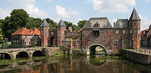
Koppelpoort
Distance: Approx. 3364 meters
Latitude and longitude: 52.15888889,5.38527778
The Koppelpoort is a medieval gate in the Dutch city of Amersfoort, province of Utrecht. Completed around 1425, it combines land and water-gates, and is part of the second city wall of Amersfoort, which was constructed between 1380 and 1450.
Hoogland
Place in Utrecht, Netherlands
Distance: Approx. 3124 meters
Latitude and longitude: 52.18722222,5.37444444
Hoogland (Dutch pronunciation: [ˈɦoːxlɑnt]) is a village and former free-standing municipality in the province of Utrecht in the Netherlands. It is located north of the Amersfoort city centre. The village population is 10,587 people (2006).

Hooglanderveen
Village in Utrecht, Netherlands
Distance: Approx. 1126 meters
Latitude and longitude: 52.18888889,5.42916667
Hooglanderveen (Dutch pronunciation: [ˌɦoːxlɑndərˈveːn]) is a village in the Dutch province of Utrecht. It is a part of the municipality of Amersfoort, and lies about 4 km northeast of Amersfoort. It is notable for the presence of a large Catholic church.
Stoutenburg
Village and neighbourhood in Utrecht, Netherlands
Distance: Approx. 3144 meters
Latitude and longitude: 52.15388889,5.4325
Stoutenburg is a village in the Dutch province of Utrecht. It is a part of the municipality of Leusden, and lies about 4 km (2 mi) east of Amersfoort. Since 1998, a part of the village is a neighbourhood in Amersfoort.
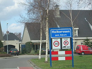
Holkerveen
Hamlet in Gelderland, Netherlands
Distance: Approx. 2997 meters
Latitude and longitude: 52.2,5.45
Holkerveen is a hamlet in the Dutch province of Gelderland. It is a part of the municipality of Nijkerk and lies about six kilometers northeast of Amersfoort. It was first mentioned in 1994 as Holkerveen, and means bog near Holk.

Amersfoort Schothorst railway station
Railway station in Amersfoort, Netherlands
Distance: Approx. 1258 meters
Latitude and longitude: 52.17472222,5.40361111
Amersfoort Schothorst is a railway station on the Utrecht–Kampen railway between Amersfoort and Zwolle. It is located in north Amersfoort, Netherlands. The station is operated by Nederlandse Spoorwegen (NS).

Amersfoort Vathorst railway station
Railway station in Amersfoort, Netherlands
Distance: Approx. 1630 meters
Latitude and longitude: 52.1925,5.43361111
Amersfoort Vathorst is a railway station on the Utrecht–Kampen railway between Amersfoort and Zwolle. It is located in north Amersfoort, Netherlands. The station is operated by the Nederlandse Spoorwegen (NS).
Intres B.V.
Distance: Approx. 2860 meters
Latitude and longitude: 52.16940556,5.45650833
Intres B.V. (International Retail Support) is a Dutch retail organisation, established in Hoevelaken. The company provides various services to owners of shops and is franchisor of such brands as Intersport, Livera and Libris.

Hoevelaken railway station
Railway station in the Netherlands
Distance: Approx. 3051 meters
Latitude and longitude: 52.16638889,5.45694444
Hoevelaken is a railway station in the municipality of Amersfoort (province of Utrecht) near Hoevelaken, the Netherlands. The station lies on the Oosterspoorweg, but is only served by Connexxion trains from the Valleilijn and opened on 9 December 2012. Previously, Hoevelaken had a station on the Utrecht - Zwolle railway line from 1905 to 1938.
Schothorst
Distance: Approx. 1909 meters
Latitude and longitude: 52.1742,5.3933
Schothorst is the second largest district by population in the Dutch city of Amersfoort. It is located in central Amersfoort, between the districts of Liendert, Landgoed Schothorst (an estate) and De Koppel. The neighbourhood was built in the 1970s and 1980s and today forms a quiet, leafy area of the city.
De Saffraan
Restaurant in Amersfoort, Netherlands
Distance: Approx. 3371 meters
Latitude and longitude: 52.16053333,5.3825
De Saffraan is a restaurant located in Amersfoort in the Netherlands. It is a fine dining restaurant that was awarded one Michelin star in the period 2010–2014. GaultMillau awarded the restaurant 15 out of 20 points.

Flint (theatre)
Distance: Approx. 2950 meters
Latitude and longitude: 52.15986111,5.39277778
Flint, formerly De Flint, is a theatre in the centre of Amersfoort, Netherlands built in 1977. It was designed by Onno Greiner. The Flint programme includes play, musicals, cabaret and performances for children.
Weather in this IP's area
light rain
15 Celsius
15 Celsius
14 Celsius
16 Celsius
1013 hPa
92 %
1013 hPa
1013 hPa
10000 meters
1.35 m/s
1.46 m/s
303 degree
98 %
08:08:52
18:37:38