Country:
 USA
USARegion:
City:
Latitude and Longitude:
Time Zone:
Postal Code:
IP information under different IP Channel
ip-api
Country
Region
City
ASN
Time Zone
ISP
Blacklist
Proxy
Latitude
Longitude
Postal
Route
IPinfo
Country
Region
City
ASN
Time Zone
ISP
Blacklist
Proxy
Latitude
Longitude
Postal
Route
MaxMind
Country
Region
City
ASN
Time Zone
ISP
Blacklist
Proxy
Latitude
Longitude
Postal
Route
Luminati
Country
USRegion
az
City
scottsdale
ASN
Time Zone
America/Phoenix
ISP
BAM
Latitude
Longitude
Postal
db-ip
Country
Region
City
ASN
Time Zone
ISP
Blacklist
Proxy
Latitude
Longitude
Postal
Route
ipdata
Country
Region
City
ASN
Time Zone
ISP
Blacklist
Proxy
Latitude
Longitude
Postal
Route
Popular places and events near this IP address

Carefree, Arizona
Town in Maricopa County, Arizona
Distance: Approx. 7820 meters
Latitude and longitude: 33.82333333,-111.91611111
Carefree is a town in Maricopa County, Arizona, United States. It is a suburb of both Phoenix and Scottsdale, located in the far northeast area of the Phoenix Metropolitan Area. As of the 2020 United States census, the population of the town was 3,690.

Cave Creek, Arizona
Town in Maricopa County, Arizona
Distance: Approx. 4833 meters
Latitude and longitude: 33.85138889,-111.98
Cave Creek is a town in Maricopa County, Arizona, United States. It is part of the Phoenix metropolitan area. As of the 2020 census, the population of the town was 4,892.

Phallic Rock
Geological feature in Carefree, Arizona, United States
Distance: Approx. 8575 meters
Latitude and longitude: 33.81360556,-111.92420833
Phallic Rock is a precambrian granite rock formation in Carefree, Arizona, United States. The formation is caused by spheroidal weathering whereby the composition of the granite and its crystal structure facilitated the development of rounded corners and its unique phallic tubular shape. The formation is at the eastern foot of Black Mountain and can be found approximately 400 ft (120 m) east of Tom Darlington Drive on Stagecoach Pass Road.
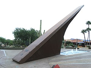
Carefree sundial
Sundial in Carefree, Arizona, US
Distance: Approx. 7522 meters
Latitude and longitude: 33.8242,-111.922
The Carefree Sundial, in Carefree, Arizona, was designed by architect Joe Wong and solar engineer John I. Yellott (1908–1986), was erected in the Sundial Circle plaza in 1959. The sundial is made from a steel frame and covered in anodized copper. As originally designed the 1200mm wide gnomon acted as a heat collecting plate for a local heating scheme.
Grace Museum of America
History museum in Arizona, US
Distance: Approx. 2818 meters
Latitude and longitude: 33.877,-111.923
The Grace Museum of America is located in Cave Creek, Arizona in the mountains of the Sonoran Desert. The museum was started by Grace Voss Frederick and houses a collection of historical objects from significant times in American history. According to Frederick, the museum is intended to document America's "transition from a primitive country to a great nation".
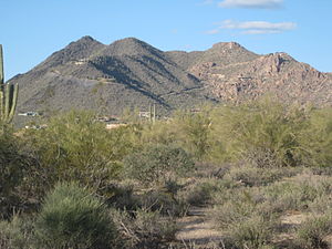
Black Mountain (Maricopa County, Arizona)
Landform
Distance: Approx. 8080 meters
Latitude and longitude: 33.81524315,-111.94135886
Black Mountain is located in north-central Maricopa County, Arizona, between the towns of Carefree and Cave Creek.
Desert Forest Golf Club
Golf course and club in Carefree, Arizona
Distance: Approx. 8614 meters
Latitude and longitude: 33.822,-111.901
Desert Forest Golf Club is a par-72 golf course and club located in Carefree, Arizona. The course is 7201 yards long and located underneath Black Mountain in the Sonoran desert.

Cave Creek Service Station
United States historic place
Distance: Approx. 6181 meters
Latitude and longitude: 33.83194444,-111.9475
The Cave Creek Service Station, at 6141 Cave Creek Rd. in Cave Creek, Arizona, was built in 1936. It was listed on the National Register of Historic Places in 2000.

Cave Creek Museum
History and culture museum in Arizona, US
Distance: Approx. 6510 meters
Latitude and longitude: 33.82896,-111.94832
The Cave Creek Museum is a 501(c)(3) non-profit entity at the base of the Black Mountains in the town of Cave Creek in Maricopa County, Arizona, United States. The museum preserves artifacts of the prehistory and objects related to the culture of the Cave Creek/Carefree foothills area. The museum consists of various exhibits, indoor and outdoor.
Weather in this IP's area
clear sky
20 Celsius
20 Celsius
19 Celsius
21 Celsius
1006 hPa
46 %
1006 hPa
924 hPa
10000 meters
0.89 m/s
3.13 m/s
221 degree
06:35:28
17:49:52