Country:
 USA
USARegion:
City:
Latitude and Longitude:
Time Zone:
Postal Code:
IP information under different IP Channel
ip-api
Country
Region
City
ASN
Time Zone
ISP
Blacklist
Proxy
Latitude
Longitude
Postal
Route
IPinfo
Country
Region
City
ASN
Time Zone
ISP
Blacklist
Proxy
Latitude
Longitude
Postal
Route
MaxMind
Country
Region
City
ASN
Time Zone
ISP
Blacklist
Proxy
Latitude
Longitude
Postal
Route
Luminati
Country
USASN
Time Zone
America/Chicago
ISP
HCLTA94085
Latitude
Longitude
Postal
db-ip
Country
Region
City
ASN
Time Zone
ISP
Blacklist
Proxy
Latitude
Longitude
Postal
Route
ipdata
Country
Region
City
ASN
Time Zone
ISP
Blacklist
Proxy
Latitude
Longitude
Postal
Route
Popular places and events near this IP address

Newark, New Jersey
Most populous city in New Jersey, United States
Distance: Approx. 22 meters
Latitude and longitude: 40.73555556,-74.17222222
Newark ( NEW-ərk, locally: [nʊɹk]) is the most populous city in the U.S. state of New Jersey, the county seat of Essex County, and a principal city of the New York metropolitan area. As of the 2020 census, the city's population was 311,549. The Population Estimates Program calculated a population of 304,960 for 2023, making it the 66th-most populous municipality in the nation.

Downtown Newark
Central business district in United States
Distance: Approx. 60 meters
Latitude and longitude: 40.73611111,-74.17194444
Downtown Newark is the central business district of Newark in Essex County, in the U.S. state of New Jersey. Downtown is the site of the original Puritan settlement of Newark located at a bend in the Passaic River. The first settlers, led by Robert Treat, landed not far from the present site of the New Jersey Performing Arts Center.
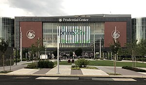
Prudential Center
Multi-purpose indoor arena in Newark, New Jersey, U.S.
Distance: Approx. 257 meters
Latitude and longitude: 40.73361111,-74.17111111
Prudential Center is a multipurpose indoor arena in the central business district of Newark, New Jersey, United States. Opened in 2007, it is the home of the New Jersey Devils of the National Hockey League (NHL), the New York Sirens of the Professional Women's Hockey League (PWHL) and the Seton Hall Pirates men's basketball team. By 2023, it was among the top five concert venues worldwide by earnings.
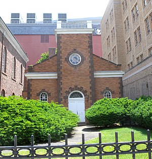
Old First Presbyterian Church (Newark, New Jersey)
Historic church in New Jersey, United States
Distance: Approx. 171 meters
Latitude and longitude: 40.73416667,-74.1725
The Old First Presbyterian Church, also known as First Presbyterian Church and Cemetery, is a church in Newark, Essex County, New Jersey, United States. The church was listed on the National Register of Historic Places in 1972. The grounds, located in the Four Corners Historic District, includes an old burial ground.

Military Park station
Distance: Approx. 201 meters
Latitude and longitude: 40.73722222,-74.17111111
Military Park station (formerly Broad Street station) is an underground station on the Newark City Subway Line of the Newark Light Rail. The station is owned and service is operated by New Jersey Transit. The station is located at the intersection of Raymond Boulevard, Park Place and Broad Street in Downtown Newark at Military Park.

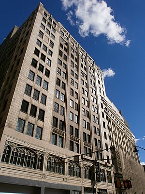
National Newark Building
Skyscraper in Newark, New Jersey, US
Distance: Approx. 157 meters
Latitude and longitude: 40.736653,-74.171032
The National Newark Building (Formerly the National Newark and Essex Bank Building) is a neo-classical office skyscraper in Newark, New Jersey. It has been the tallest building in Newark since 1931 and was tallest in New Jersey until 1989. At thirty-five stories, it has a height of 466 ft (142 m).

Eleven 80
Residential in Newark, New Jersey
Distance: Approx. 262 meters
Latitude and longitude: 40.7372,-74.17
Eleven80 is a 137 m (449 ft) tall residential skyscraper in Newark, New Jersey. Named for its address at 1180 Raymond Boulevard, Eleven80 is located in Downtown Newark, just north of Four Corners across from Military Park. A hallmark of the Newark skyline since its construction as a 36-story office building in 1930, it is noted for its Art Deco detail and ornamentation.

First National State Bank Building
United States historic place
Distance: Approx. 110 meters
Latitude and longitude: 40.73472222,-74.17222222
The First National State Bank Building, also known as the Indigo Residence, is located at 810 Broad Street in Newark, Essex County, New Jersey, United States. The building was designed by Cass Gilbert and was built in 1912. The building stands 165 ft (50 m) and is twelve stories tall with a steel frame and with a facade of applied masonry.

Four Corners (Newark)
Historic district in Essex County, New Jersey, US
Distance: Approx. 25 meters
Latitude and longitude: 40.73556,-74.172172
The Four Corners Historic District is the intersection of Broad and Market Streets in Newark, New Jersey. It is the site of the city's earliest settlement and the heart of Downtown Newark that at one time was considered the busiest intersection in the United States. The area that radiates twenty-two square blocks from the crossroads is a state and federal historic district.
165 Halsey Street
Building in Newark, New Jersey
Distance: Approx. 174 meters
Latitude and longitude: 40.736817,-74.173851
165 Halsey Street, formerly known as the Bamberger Building, is a 14-story, office tower in Downtown Newark, New Jersey. Built in 1912–1929, it was designed by Jarvis Hunt. The building spans the entire block between Halsey Street, Market Street, Washington Street, and Bank Street.
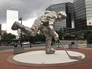
Statue of Hockey Player
Sculpture
Distance: Approx. 243 meters
Latitude and longitude: 40.73472,-74.16983
The Hockey Player statue is a sculpture located at Championship Plaza, adjacent to the Prudential Center in Newark, New Jersey, home of the New Jersey Devils hockey team, installed in 2009. Entitled Stanley by the artist it has been colloquially known as Iceman, Man of Steel, and the Iron Man. The stainless steel work of an anonymous hockey player taking a slapshot is 22 feet (6.7 m) tall and weighs 7,000 pounds (3,200 kg).
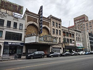
Newark Paramount Theatre
Vaudeville house and movie theater in Newark, New Jersey
Distance: Approx. 118 meters
Latitude and longitude: 40.73555,-74.17101
The Newark Paramount Theatre is an abandoned vaudeville house turned "movie palace" film theatre in the Four Corners Historic District in Downtown Newark, New Jersey.
Weather in this IP's area
broken clouds
22 Celsius
22 Celsius
21 Celsius
23 Celsius
1015 hPa
65 %
1015 hPa
1014 hPa
10000 meters
2.68 m/s
4.02 m/s
214 degree
62 %
06:42:41
18:57:18