Country:
Region:
City:
Latitude and Longitude:
Time Zone:
Postal Code:
IP information under different IP Channel
ip-api
Country
Region
City
ASN
Time Zone
ISP
Blacklist
Proxy
Latitude
Longitude
Postal
Route
Luminati
Country
ASN
Time Zone
Europe/Lisbon
ISP
Fundacao para a Ciencia e a Tecnologia, I.P.
Latitude
Longitude
Postal
IPinfo
Country
Region
City
ASN
Time Zone
ISP
Blacklist
Proxy
Latitude
Longitude
Postal
Route
db-ip
Country
Region
City
ASN
Time Zone
ISP
Blacklist
Proxy
Latitude
Longitude
Postal
Route
ipdata
Country
Region
City
ASN
Time Zone
ISP
Blacklist
Proxy
Latitude
Longitude
Postal
Route
Popular places and events near this IP address

Instituto Nacional de Estatística (Portugal)
Portuguese government institution
Distance: Approx. 677 meters
Latitude and longitude: 38.73861111,-9.13777778
The Instituto Nacional de Estatística or INE (Portuguese for 'National Institute for Statistics') is the government office for national statistics of Portugal. In the English language it is also branded as Statistics Portugal. The INE is one of the components of the Portuguese National Statistical System (SEN), which also includes the Higher Council of Statistics, the Bank of Portugal and the regional statistical services the autonomous regions of the Azores and Madeira.
Alto do Pina, Lisbon
Civil parish in Lisbon, Portugal
Distance: Approx. 430 meters
Latitude and longitude: 38.74,-9.128
Alto do Pina (Portuguese pronunciation: [ˈaltu ðu ˈpinɐ]) was a Portuguese parish, located in the municipality of Lisbon. It had a population of 10,253 inhabitants and a total area of 0.82 km2. With the 2012 Administrative Reform, the parish merged with the São João de Deus parish into a new one named Areeiro.

Alvalade
Civil parish in Lisbon, Portugal
Distance: Approx. 621 meters
Latitude and longitude: 38.747,-9.136
Alvalade (Portuguese pronunciation: [alvɐˈlaðɨ]) is a freguesia (civil parish) and typical quarter of Lisbon, the capital city of Portugal. Located in central Lisbon, Alvalade is south of Lumiar and Olivais, west of Marvila, east of São Domingos de Benfica, and north of Avenidas Novas and Areeiro. The population in 2021 was 33,309.

Teatro Maria Matos
Theatre in Lisbon, Portugal
Distance: Approx. 720 meters
Latitude and longitude: 38.74583333,-9.13888889
The Maria Matos Theatre (Portuguese: Teatro Maria Matos) is a theatre located in the civil parish of Alvalade, in the municipality and Portuguese capital of Lisbon.
Caritas Portugal
Distance: Approx. 397 meters
Latitude and longitude: 38.74106,-9.13596
Caritas Portugal (Portuguese: Cáritas Portuguesa) is the official Catholic Church organization in Portugal for charity and social relief, instituted by the Portuguese Episcopal Conference. Caritas Portuguesa was founded in 1945, with its first statutes approved in 1956. From the 1950s to mid-1970s, its activities focused primarily on the distribution of food to the Portuguese population, donated by the United States, and the hosting of children from Central European countries in the aftermath of World War II and the beginning of Cold War tensions.

Olaias Station
Metro station in Lisbon, Portugal
Distance: Approx. 758 meters
Latitude and longitude: 38.73916667,-9.12416667
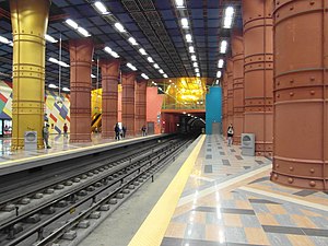
Olaias is a station on the Red Line of the Lisbon Metro. The station is located on Rua de Olivença southeast of Avenida Engenheiro Arantes e Oliveira in the Olaias neighbourhood to the north east of central Lisbon.

Alameda Station
Metro station in Lisbon, Portugal
Distance: Approx. 675 meters
Latitude and longitude: 38.73666667,-9.13388889
Alameda is a station on the Green and Red Lines of the Lisbon Metro. The station is located on Avenida Almirante Reis at Alameda Dom Afonso Henriques, east of the Instituto Superior Técnico.

Areeiro, Lisbon
Civil parish in Lisbon, Portugal
Distance: Approx. 201 meters
Latitude and longitude: 38.742,-9.134
Areeiro (Portuguese pronunciation: [ɐˈɾjɐjɾu]) is a freguesia (civil parish) and typical quarter of Lisbon, the capital city of Portugal. Located in central Lisbon, Areeiro is east of Avenidas Novas, east of Marvila, south of Alvalade, and north of Beato, Penha de França, and Arroios. The population in 2021 was 21,160.
Areeiro Station
Metro station in Lisbon, Portugal
Distance: Approx. 162 meters
Latitude and longitude: 38.74277778,-9.13361111
Areeiro is a station on the Green Line of the Lisbon Metro serving the Areeiro neighbourhood. The station is located in the Praça Francisco Sá Carneiro, just south of the Roma-Areeiro railway station.
Escola Secundária Artística António Arroio
Secondary school in Portugal
Distance: Approx. 814 meters
Latitude and longitude: 38.736111,-9.127222
The Escola Artística António Arroio (António Arroio School of Arts) is a secondary school in Lisbon, Portugal that specializes in the applied arts.

Quinta dos Lagares d'El-Rei
Quinta in Lisbon, Portugal
Distance: Approx. 612 meters
Latitude and longitude: 38.7475,-9.13472222
The Quinta dos Lagares d'El-Rei (Portuguese: Solar da Quinta dos Lagares d'El-Rei; [ˈkĩtɐ ðuʒ lɐˈɣaɾɨʒ ðɛl ˈʁɐj], "Estate of the King's Wine-Vats"), is a quinta and manor house on the Portuguese estate of Quinta dos Lagares d'El-Rei, part of the Senhorio dos Lagares d'El-Rei (the Majorat of Lagares), a feudal fiefdom, seated in the civil parish of Alvalade, in the municipality of Lisbon.

Roma-Areeiro railway station
Railway station in Lisbon, Portugal
Distance: Approx. 495 meters
Latitude and longitude: 38.74583333,-9.13555556
Roma-Areeiro Station (Portuguese: Estação Ferroviária de Roma-Areeiro) is a railway station located in the city of Lisbon. It is served by the Sintra and Azambuja Lines, as well as the private operator Fertagus. It is managed by Infraestruturas de Portugal.
Weather in this IP's area
broken clouds
20 Celsius
20 Celsius
19 Celsius
21 Celsius
1020 hPa
73 %
1020 hPa
1010 hPa
10000 meters
6.69 m/s
220 degree
75 %
07:08:08
17:32:07
