192.67.164.169 - IP Lookup: Free IP Address Lookup, Postal Code Lookup, IP Location Lookup, IP ASN, Public IP
Country:
 USA
USARegion:
City:
Location:
Time Zone:
Postal Code:
ISP:
ASN:
language:
User-Agent:
Proxy IP:
Blacklist:
IP information under different IP Channel
ip-api
Country
Region
City
ASN
Time Zone
ISP
Blacklist
Proxy
Latitude
Longitude
Postal
Route
db-ip
Country
Region
City
ASN
Time Zone
ISP
Blacklist
Proxy
Latitude
Longitude
Postal
Route
IPinfo
Country
Region
City
ASN
Time Zone
ISP
Blacklist
Proxy
Latitude
Longitude
Postal
Route
IP2Location
192.67.164.169Country
usRegion
new jersey
City
clifton
Time Zone
America/New_York
ISP
Language
User-Agent
Latitude
Longitude
Postal
ipdata
Country
Region
City
ASN
Time Zone
ISP
Blacklist
Proxy
Latitude
Longitude
Postal
Route
Popular places and events near this IP address

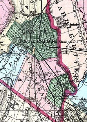
Clifton, New Jersey
City in Passaic County, New Jersey, US
Distance: Approx. 1521 meters
Latitude and longitude: 40.862137,-74.160393
Clifton is a city in Passaic County, in the U.S. state of New Jersey. Criss-crossed by several major highways, the city is a regional commercial hub for North Jersey and is a bedroom suburb of New York City in the New York Metropolitan Area. As of the 2020 United States Census, the city retained its position as the state's 11th-most-populous municipality, just behind tenth-ranked Trenton, and well ahead of Cherry Hill in twelfth place, with a population of 90,296, reflecting an overall increase of 6,160 (+7.3%) from the 2010 census count of 84,136, which in turn reflected an overall increase of 5,464 (+6.9%) from the 78,672 counted in the 2000 census.

WPAT (AM)
Multicultural radio station in Paterson, New Jersey (New York City)
Distance: Approx. 1971 meters
Latitude and longitude: 40.84982222,-74.18264444
WPAT (930 AM), is a radio station licensed to Paterson, New Jersey, with a brokered programming format. WPAT is owned by Multicultural Broadcasting, and its studios are located in New York City, in Manhattan's Financial District. The station's four 380 feet (120 m) transmitting towers are located in Clifton, New Jersey.
WNSW
Relevant Radio station in Newark, New Jersey
Distance: Approx. 2005 meters
Latitude and longitude: 40.84972222,-74.18305556
WNSW (1430 AM) is a religious-formatted broadcast radio station, licensed to Newark, New Jersey, and serving the New York Metropolitan area. WNSW has been owned and operated by Relevant Radio, a Roman Catholic radio network, since 2014. It transmits from the four towers leased from WPAT (AM) in Clifton.
Acquackanonk Township, New Jersey
Former township in New Jersey, United States (1693–1917)
Distance: Approx. 1435 meters
Latitude and longitude: 40.86138889,-74.15888889
Acquackanonk Township was a township that existed in New Jersey, United States, from 1693 until 1917, first in Essex County and then in Passaic County.
Clifton Public Schools
Public school district in Passaic County, New Jersey, US
Distance: Approx. 1914 meters
Latitude and longitude: 40.865681,-74.160278
The Clifton Public Schools is a comprehensive community public school district that serves students in pre-kindergarten through twelfth grade from Clifton, in Passaic County, in the U.S. state of New Jersey. As of the 2020–21 school year, the district, comprising 18 schools, had an enrollment of 10,514 students and 870.5 classroom teachers (on an FTE basis), for a student–teacher ratio of 12.1:1. The district is classified by the New Jersey Department of Education as being in District Factor Group "CD", the sixth-highest of eight groupings.
Sybase Classic
Golf tournament formerly on the LPGA Tour
Distance: Approx. 1323 meters
Latitude and longitude: 40.848,-74.175
The Sybase Classic was a women's professional golf tournament on the LPGA Tour for twenty years, from 1990 to 2009. The event was originally known as the "Big Apple Classic", but the name was dropped in 2007 when the tournament relocated from the New York City area to New Jersey. From 1992 through 2006, ShopRite sponsored the ShopRite LPGA Classic in Atlantic City.

Passaic station (NJ Transit)
NJ Transit rail station
Distance: Approx. 2158 meters
Latitude and longitude: 40.8494,-74.1337
Passaic is a NJ Transit rail station served by Main Line trains in Passaic, New Jersey. The station is located in the Passaic Park section of Passaic at an intersection that links Passaic Avenue and Van Houten Avenue with Lackawanna Place. The Hoboken bound platform is located on the Passaic Avenue side of the station and the Suffern bound platform is located at the intersection of Van Houten Avenue and Lackawanna Place.
PBI Regional Medical Center
Distance: Approx. 2202 meters
Latitude and longitude: 40.8592,-74.1373
The PBI Regional Medical Center was a hospital in Passaic, New Jersey which was located on Boulevard, between Oak Street and Howe Avenue (now home to St. Mary's Hospital).
Roche Institute of Molecular Biology
Research institute in Nutley, New Jersey, US
Distance: Approx. 1879 meters
Latitude and longitude: 40.8321,-74.154
The Roche Institute of Molecular Biology was created on July 14, 1967 when John Burns, then the vice president of research at Hoffman-La Roche, persuaded biochemist Sidney Udenfriend to leave the National Institutes of Health and help him create a basic science institute at the Hoffman-La Roche Nutley, New Jersey, facility. It lasted for 28 years and was associated with a number of well-known and well-regarded scientists. At one time, it was one of the largest post-doctoral training programs funded by industry with approximately 70 fellows.
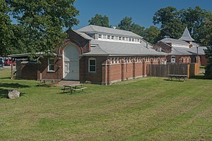
U.S. Animal Quarantine Station
United States historic place
Distance: Approx. 2188 meters
Latitude and longitude: 40.86805556,-74.16194444
The United States Animal Quarantine Station is located in the city of Clifton in Passaic County, New Jersey, United States. The buildings were built in 1900. The facility, considered the Ellis Island for Animals, closed in 1975.
Upper Montclair Country Club
Golf course in New Jersey, USA
Distance: Approx. 1331 meters
Latitude and longitude: 40.847726,-74.175075
Upper Montclair Country Club is an A. W. Tillinghast-designed golf course located in Clifton, New Jersey.

Hackensack Meridian School of Medicine
Private medical school in Nutley, New Jersey
Distance: Approx. 1712 meters
Latitude and longitude: 40.8334544,-74.1551057
Hackensack Meridian School of Medicine (HMSOM) is a private medical school in Nutley, New Jersey. It opened in 2015, becoming the first private medical school in New Jersey to open in decades. Originally affiliated with Seton Hall University, the Hackensack Meridian School of Medicine became independent in 2020.
Weather in this IP's area
broken clouds
0 Celsius
-5 Celsius
-0 Celsius
1 Celsius
1029 hPa
60 %
1029 hPa
1023 hPa
10000 meters
5.14 m/s
8.23 m/s
330 degree
75 %