192.65.91.34 - IP Lookup: Free IP Address Lookup, Postal Code Lookup, IP Location Lookup, IP ASN, Public IP
Country:
Region:
City:
Location:
Time Zone:
Postal Code:
IP information under different IP Channel
ip-api
Country
Region
City
ASN
Time Zone
ISP
Blacklist
Proxy
Latitude
Longitude
Postal
Route
Luminati
Country
ASN
IPinfo
Country
Region
City
ASN
Time Zone
ISP
Blacklist
Proxy
Latitude
Longitude
Postal
Route
IP2Location
192.65.91.34Country
Region
australian capital territory
City
canberra
Time Zone
Australia/Sydney
ISP
Language
User-Agent
Latitude
Longitude
Postal
db-ip
Country
Region
City
ASN
Time Zone
ISP
Blacklist
Proxy
Latitude
Longitude
Postal
Route
ipdata
Country
Region
City
ASN
Time Zone
ISP
Blacklist
Proxy
Latitude
Longitude
Postal
Route
Popular places and events near this IP address
North Canberra
Place in Australian Capital Territory
Distance: Approx. 246 meters
Latitude and longitude: -35.28138889,149.12888889
North Canberra, or the Inner North, is a subdivision of Canberra Central in the Australian Capital Territory in Australia. Comprising 14 suburbs. At the 2021 census, it had 26,699 dwellings housing 61,188 people of the 453,324 people in the Australian Capital Territory.

Civic, Australian Capital Territory
Suburb of Canberra, Australian Capital Territory
Distance: Approx. 173 meters
Latitude and longitude: -35.282,149.1286
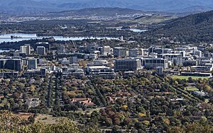
Civic is the city centre or central business district of Canberra. "Civic" is a common name for the district, but it is also called Civic Centre, City Centre, Canberra City and Canberra, and its official division name is City. Canberra's City was established in 1927, although the division name City was not gazetted until 20 September 1928.

Division of Australian Capital Territory
Former Australian federal electoral division
Distance: Approx. 155 meters
Latitude and longitude: -35.2822,149.1287
The Division of Australian Capital Territory was an Australian electoral division in the Territory of the same name. The division was created in 1949 and included the whole of the city of Canberra and surrounding rural areas. Prior to 1949, the Australian Capital Territory (ACT) had no representation in the Australian Parliament.

Supreme Court of the Australian Capital Territory
Superior court of the Australian Capital Territory, Australia
Distance: Approx. 287 meters
Latitude and longitude: -35.281015,149.127245
The Supreme Court of the Australian Capital Territory is the highest court of the Australian Capital Territory (ACT). It has unlimited jurisdiction within the territory in civil matters and hears the most serious criminal matters. The court has the jurisdictional power to hear matters that relate to the Jervis Bay Territory, the Australian Antarctic Territory and the Heard Island and McDonald Islands, although it has never heard a case exercising its power over the Heard and McDonald Islands.

City Hill, Canberra
Park in Canberra, Australia
Distance: Approx. 179 meters
Latitude and longitude: -35.28194444,149.12861111
City Hill is a park located in Canberra, Australia, on one of the points of the Parliamentary Triangle, a feature of Walter Burley Griffin's plan for the city. The park is surrounded by Vernon Circle, at the south end of Northbourne Avenue, but beyond Vernon Circle it is further surrounded by the concentric London Circuit, and the area between Vernon Circle and London Circuit (which is partly built up) can also be seen as part of the hill. City Hill is an integral part of the city centre design.
Canberra Theatre Centre
Performing arts venue in Canberra, Australia
Distance: Approx. 289 meters
Latitude and longitude: -35.2818,149.1305
Canberra Theatre Centre (CTC), also known as the Canberra Theatre, is the Australian Capital Territory’s central performing arts venue and Australia's first performing arts centre, the first Australian Government initiated performing arts centre to be completed. It opened on 24 June 1965 with a gala performance by the Australian Ballet. The centre is sited in the heart of Canberra city centre, beside the ACT Legislative Assembly and backing onto City Hill, one of the apexes of the Parliamentary Triangle.
Australian Capital Territory House of Assembly
Former legislature of the Australian Capital Territory
Distance: Approx. 338 meters
Latitude and longitude: -35.2817,149.1311
The Australian Capital Territory House of Assembly was the main elected representative body of the Australian Capital Territory between 1975 and 1986, during which time preparation began for the granting of self-government to the Territory. The Assembly had a largely advisory role, with most of the power over the Territory being in the hands of the relevant federal minister.

Vernon Circle
Road in Canberra, Australia
Distance: Approx. 186 meters
Latitude and longitude: -35.282,149.129
Vernon Circle is a road in Canberra, Australia that encircles City Hill. It was named after Walter Liberty Vernon.

Canberra Centenary Column
Monument in City Hill, Canberra
Distance: Approx. 252 meters
Latitude and longitude: -35.28143,149.12921
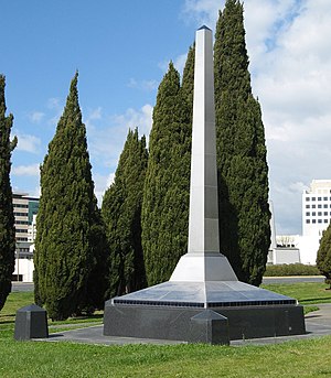
The Canberra Centenary Column is a sculpture in City Hill, Canberra, Australia. It was built to commemorate the city's centenary, and unveiled on 11 March 2014. The sculpture is an 8.5-metre (28 ft) stainless steel obelisk on a 5-metre-wide (16 ft) granite-dressed concrete base.
Division of Canberra (Australian Capital Territory House of Assembly)
Distance: Approx. 338 meters
Latitude and longitude: -35.2817,149.1311
The division of Canberra was one of the two electorates of the unicameral Australian Capital Territory House of Assembly. It elected 9 members in 1975 and 1979, and 10 members in 1982. It was named for the city of Canberra, Australia's national capital, and included the districts of Tuggeranong, Weston Creek and Woden Valley, along with the rest of the ACT south of the Molonglo River and Lake Burley Griffin.
Division of Fraser (Australian Capital Territory House of Assembly)
Distance: Approx. 338 meters
Latitude and longitude: -35.2817,149.1311
The division of Fraser was one of the two electorates of the unicameral Australian Capital Territory House of Assembly. It elected 9 members in 1975 and 1979, and 8 members in 1982. It was named for Jim Fraser, who was the Member for Australian Capital Territory from 1951 to 1970.

QT Canberra
Hotel in Canberra, Australia
Distance: Approx. 232 meters
Latitude and longitude: -35.28361111,149.12555556
QT Canberra is a hotel in Canberra, Australia. Construction began on the 215 room Lakeside Hotel at 1 London Circuit in 1970. Designed by Peddle, Thorp & Walker, it was built by Mainline Corporation.
Weather in this IP's area
broken clouds
18 Celsius
17 Celsius
16 Celsius
18 Celsius
1017 hPa
76 %
1017 hPa
951 hPa
10000 meters
0.52 m/s
0.85 m/s
259 degree
56 %

