192.64.92.68 - IP Lookup: Free IP Address Lookup, Postal Code Lookup, IP Location Lookup, IP ASN, Public IP
Country:
Region:
City:
Location:
Time Zone:
Postal Code:
IP information under different IP Channel
ip-api
Country
Region
City
ASN
Time Zone
ISP
Blacklist
Proxy
Latitude
Longitude
Postal
Route
Luminati
Country
ASN
Time Zone
America/Chicago
ISP
ALPHE
Latitude
Longitude
Postal
IPinfo
Country
Region
City
ASN
Time Zone
ISP
Blacklist
Proxy
Latitude
Longitude
Postal
Route
IP2Location
192.64.92.68Country
Region
texas
City
san antonio
Time Zone
America/Chicago
ISP
Language
User-Agent
Latitude
Longitude
Postal
db-ip
Country
Region
City
ASN
Time Zone
ISP
Blacklist
Proxy
Latitude
Longitude
Postal
Route
ipdata
Country
Region
City
ASN
Time Zone
ISP
Blacklist
Proxy
Latitude
Longitude
Postal
Route
Popular places and events near this IP address

Central Catholic Marianist High School
Private, day, college-prep school in San Antonio, Texas, United States
Distance: Approx. 238 meters
Latitude and longitude: 29.43666667,-98.48527778
Central Catholic High School is a Catholic, all-male, non-boarding college preparatory school located in the River North District of Downtown San Antonio, Texas, USA, in the Roman Catholic Archdiocese of San Antonio.
Pearl Brewing Company
Former brewery in San Antonio, Texas
Distance: Approx. 806 meters
Latitude and longitude: 29.44408,-98.48031
The Pearl Brewing Company (also known as the Pearl Brewery or just Pearl) was an American brewery established in 1883 in downtown San Antonio, Texas, United States. In 1985, Pearl's parent company purchased the Pabst Brewing Company and assumed the Pabst name. In 1999, the Pabst Brewing Company began transferring its production to Miller Brewing on a contract basis and closed all of its own breweries.
Earl Abel's
Restaurant in San Antonio, Texas
Distance: Approx. 703 meters
Latitude and longitude: 29.4416668,-98.477771
Earl Abel's is a popular restaurant in San Antonio, Texas that opened in 1933 and existed at one location at Broadway and Hildebrand from 1940 until 2006. It has been popular for its diverse menu ranging from Fried Chicken and Rainbow Trout to its selection of desserts including German chocolate cake and lemon meringue pie; its clientele included the well-to-do from nearby Alamo Heights, businessmen and politicians including Congressman Henry B. Gonzalez who got in a fist fight at the restaurant in 1986 with a fellow customer who called him a communist, as well as many U.S. Army personnel stationed at nearby Fort Sam Houston.
Providence High School (San Antonio)
Private school in San Antonio, , Texas, United States
Distance: Approx. 418 meters
Latitude and longitude: 29.435,-98.48638889
Providence Catholic School is a Catholic, college preparatory school for girls in Downtown San Antonio, Texas, USA. It is accredited by the Texas Catholic Conference Education Department and the Southern Association of Colleges and Schools and is a member of The College Board. It is a member of the Roman Catholic Archdiocese of San Antonio.

Old Lone Star Brewery
United States historic place
Distance: Approx. 149 meters
Latitude and longitude: 29.43694444,-98.48138889
The Old Lone Star Brewery complex is located at 200 West Jones Avenue, downtown San Antonio, county of Bexar, in the U.S. state of Texas. It was added to the National Register of Historic Places in 1972.

San Antonio Municipal Auditorium
United States historic place
Distance: Approx. 940 meters
Latitude and longitude: 29.43055556,-98.48888889
The San Antonio Municipal Auditorium was a building located at 100 Auditorium Circle, San Antonio, Texas. It was built as a memorial to American soldiers killed in World War I. The San Antonio Municipal Auditorium was also used as a concert venue. The building was rebuilt and expanded into the Tobin Center for the Performing Arts in 2009-2014.

Hotel Emma
Distance: Approx. 645 meters
Latitude and longitude: 29.44277778,-98.48111111
Hotel Emma, once a 19th-century brewhouse, is a 146-room boutique hotel in the historic Pearl District of San Antonio, Texas, United States. It has a library, bar, club room, restaurant and grocer. Hotel Emma is named after Emma Koehler, wife of Pearl President Otto Koehler.

F.I.S.H.
Distance: Approx. 305 meters
Latitude and longitude: 29.43972222,-98.48166667
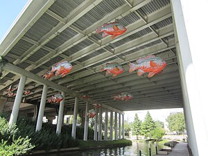
F.I.S.H. is an outdoor 2009 sculpture depicting a school of fish by Donald Lipski in San Antonio, Texas, United States. The installation is underneath the I-35 overpass over the San Antonio River near Camden Street. It features 25 7-foot (2.1 m) fiberglass resin sculptures of long-eared sunfish, each of which are hand-painted and anatomically correct.
Baptist Medical Center
Hospital, part of the Baptist Health System in San Antonio, Texas
Distance: Approx. 1019 meters
Latitude and longitude: 29.4331,-98.4923
Baptist Medical Center is a district general hospital and a part of the Baptist Health System in San Antonio, Texas. The hospital offers San Antonio's only heart transplant program. The hospital is rated with 3 out of 5 stars according to the 5-star overall rating system developed by the Centers for Medicare & Medicaid Services; it is reported that 620 medical professionals are affiliated with the hospital.

The Grotto (San Antonio)
Concrete sculpture in San Antonio, Texas, U.S.
Distance: Approx. 376 meters
Latitude and longitude: 29.44055556,-98.4825
The Grotto is a concrete sculpture by Carlos Cortés, along the San Antonio River in San Antonio, Texas, United States. In 2020, some pieces intended to be added to The Grotto were stolen.
San Antonio parade shooting
1979 mass shooting in San Antonio, Texas
Distance: Approx. 943 meters
Latitude and longitude: 29.4435,-98.4764
On April 27, 1979, 64-year-old Ira Attebury opened fire on the spectator crowd at the Battle of Flowers parade in San Antonio, Texas, killing two and injuring several dozen, including several police officers. It proceeded into a siege for over an hour, before the perpetrator then killed himself. Attebury, a WWII military veteran, was on drugs during the shooting, and believed he was being persecuted by the police.
Petty House (San Antonio)
Distance: Approx. 204 meters
Latitude and longitude: 29.43548,-98.48217
Petty House is a historic Victorian house located at 10 10th Street, San Antonio, Texas along the San Antonio River Walk.
Weather in this IP's area
clear sky
7 Celsius
4 Celsius
6 Celsius
8 Celsius
1024 hPa
62 %
1024 hPa
996 hPa
10000 meters
4.63 m/s
30 degree
