Country:
 USA
USARegion:
City:
Latitude and Longitude:
Time Zone:
Postal Code:
IP information under different IP Channel
ip-api
Country
Region
City
ASN
Time Zone
ISP
Blacklist
Proxy
Latitude
Longitude
Postal
Route
IPinfo
Country
Region
City
ASN
Time Zone
ISP
Blacklist
Proxy
Latitude
Longitude
Postal
Route
MaxMind
Country
Region
City
ASN
Time Zone
ISP
Blacklist
Proxy
Latitude
Longitude
Postal
Route
Luminati
Country
USRegion
hi
City
honolulu
ASN
Time Zone
Pacific/Honolulu
ISP
TWC-20001-PACWEST
Latitude
Longitude
Postal
db-ip
Country
Region
City
ASN
Time Zone
ISP
Blacklist
Proxy
Latitude
Longitude
Postal
Route
ipdata
Country
Region
City
ASN
Time Zone
ISP
Blacklist
Proxy
Latitude
Longitude
Postal
Route
Popular places and events near this IP address
Kamehameha Schools
Private, college-prep school in Honolulu, Hawaiʻi, United States
Distance: Approx. 2000 meters
Latitude and longitude: 21.34,-157.8575
Kamehameha Schools, formerly called Kamehameha Schools Bishop Estate (KSBE), is a private school system in Hawaiʻi established by the Bernice Pauahi Bishop Estate, under the terms of the will of Princess Bernice Pauahi Bishop, who was a formal member of the House of Kamehameha. Bishop's will established a trust called the "Bernice Pauahi Bishop Estate" that is Hawaiʻi's largest private landowner. Originally established in 1887 as an all-boys school for native Hawaiian children, it shared its grounds with the Bishop Museum.

Bishop Museum
Museum of history and science in Hawaii, United States
Distance: Approx. 2010 meters
Latitude and longitude: 21.33333333,-157.87061111
The Bernice Pauahi Bishop Museum, designated the Hawaiʻi State Museum of Natural and Cultural History, is a museum of history and science in the historic Kalihi district of Honolulu on the Hawaiian island of Oʻahu. Founded in 1889, it is the largest museum in Hawaiʻi and has the world's largest collection of Polynesian cultural artifacts and natural history specimens. Besides the comprehensive exhibits of Hawaiian cultural material, the museum's total holding of natural history specimens exceeds 24 million, of which the entomological collection alone represents more than 13.5 million specimens (making it the third-largest insect collection in the United States).

Tripler Army Medical Center
Hospital in Honolulu, Hawaiʻi
Distance: Approx. 2119 meters
Latitude and longitude: 21.36194444,-157.88944444
Tripler Army Medical Center (TAMC) is a major United States Department of Defense medical facility administered by the United States Army in the state of Hawaii. It is the tertiary care hospital in the Pacific Rim, serving local active and retired military personnel along with residents of nine U.S. jurisdictions and forces deployed in more than 40 other countries in the region. Located on the slopes of Moanalua Ridge overlooking the Honolulu neighborhoods of Moanalua and Salt Lake, Tripler Army Medical Center's massive coral pink structure can be seen from any point in the Honolulu District.
Fort Shafter
United States Army Pacific headquarters in Honolulu, Hawaii, USA
Distance: Approx. 1383 meters
Latitude and longitude: 21.345,-157.884
Fort Shafter is a census-designated place located in the City and County of Honolulu, Hawai‘i. It is the headquarters of the United States Army Pacific, which commands most Army forces in the Asia-Pacific region with the exception of Korea. Geographically, Fort Shafter extends up the interfluve (ridgeline) between Kalihi and Moanalua valleys, as well as onto the coastal plain (as Shafter Flats) at Māpunapuna.

Kalihi
Neighborhood in Honolulu, Hawaii, US
Distance: Approx. 1738 meters
Latitude and longitude: 21.33611111,-157.87638889
Kalihi is a neighborhood of Honolulu on the island of Oʻahu in Hawaiʻi, United States. Split by Likelike Highway (Route 63), it is flanked by Liliha, Chinatown, and Downtown Honolulu to the east and Mapunapuna, Moanalua, and Salt Lake to the west. Kalihi is the name of the ahupuaʻa (ancient land division) between Kahauiki and Kapālama in the Kona (now Honolulu) district of Oʻahu.

Our Lady of the Mount Catholic Church (Honolulu)
Church in USA
Distance: Approx. 1359 meters
Latitude and longitude: 21.3458,-157.8608
Our Lady of the Mount Catholic Church in Honolulu is a parish of the Roman Catholic Church of Hawaii in the United States. It falls under the jurisdiction of the Diocese of Honolulu and its bishop. Located in the Kalihi Valley neighborhood community, it once served the immigrant Portuguese pineapple and sugarcane plantation laborers of the early 20th century.

Saint John the Baptist Catholic Church (Honolulu, Hawaii)
Roman Catholic Church of Hawaii in the United States
Distance: Approx. 1752 meters
Latitude and longitude: 21.3377,-157.881
Saint John the Baptist Church is a parish church of the Roman Catholic Diocese of Honolulu in Hawaii, United States.

Moanalua Gardens
Park in Honolulu, Hawaii, US
Distance: Approx. 2110 meters
Latitude and longitude: 21.34777778,-157.8925
Moanalua Gardens is a 24-acre (97,000 m2) privately owned public park in Honolulu, Hawaii. The park is the site of the Kamehameha V Cottage which used to be the home of Prince Lot Kapuāiwa, who would later become King Kamehameha V. It is also the site of the annual Prince Lot Hula Festival, and the home of a large monkeypod tree that is known in Japan as the Hitachi tree.
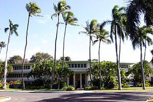
Damien Memorial School
Private school in Honolulu, Hawaii, United States
Distance: Approx. 2285 meters
Latitude and longitude: 21.33124,-157.86781
Damien Memorial School is a private Roman Catholic preparatory school for boys and girls in grades 6–12 in Kalihi, Honolulu, Hawaii, United States. Located in the Roman Catholic Diocese of Honolulu, the school is sponsored by the Congregation of Christian Brothers and is accredited by the Western Association of Schools and Colleges.
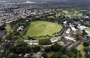
Palm Circle
United States historic place
Distance: Approx. 1849 meters
Latitude and longitude: 21.35,-157.89027778
Palm Circle or the Pineapple Pentagon, is a historic portion of Fort Shafter in Honolulu, Hawaii. Designated a National Historic Landmark in 1987, it housed the headquarters of the commanding general and his staff, U.S. Army forces, Pacific Ocean Areas, during World War II. By 1944 this command was responsible for the supply and administration of all U.S. Army personnel in the Central and South Pacific, and from 1943 to 1945, carried out logistical planning for the invasions of the Gilberts, Marshalls, Marianas, Guam, Palau, and Okinawa.
Hawaii Sports Hall of Fame
Distance: Approx. 2046 meters
Latitude and longitude: 21.3329195,-157.8728014
The Hawaii Sports Hall of Fame is a sports hall of fame and museum in the U.S. state of Hawaii. According to the hall's official website, it servers as the "state museum for sports history in the islands," and "is best described as an educational repository created to enshrine athletes, pioneers and contributors of Hawai'i's rich sports history." The organization was founded in 1997 and a selection committee meets once a year in December. The flagship exhibition for the hall is located in the Bishop Museum in Honolulu.
Helena's Hawaiian Foods
Restaurant in Honolulu, Hawaii, U.S.
Distance: Approx. 2397 meters
Latitude and longitude: 21.3309,-157.8651
Helena's Hawaiian Foods is a restaurant in Honolulu, Hawaii. The business was named one of "America's Classics" by the James Beard Foundation Awards in 2000.
Weather in this IP's area
few clouds
26 Celsius
26 Celsius
24 Celsius
28 Celsius
1013 hPa
65 %
1013 hPa
995 hPa
10000 meters
5.14 m/s
10.8 m/s
30 degree
20 %
06:16:51
18:42:03