Country:
 USA
USARegion:
City:
Latitude and Longitude:
Time Zone:
Postal Code:
IP information under different IP Channel
ip-api
Country
Region
City
ASN
Time Zone
ISP
Blacklist
Proxy
Latitude
Longitude
Postal
Route
IPinfo
Country
Region
City
ASN
Time Zone
ISP
Blacklist
Proxy
Latitude
Longitude
Postal
Route
MaxMind
Country
Region
City
ASN
Time Zone
ISP
Blacklist
Proxy
Latitude
Longitude
Postal
Route
Luminati
Country
USRegion
hi
City
kailuakona
ASN
Time Zone
Pacific/Honolulu
ISP
TWC-20001-PACWEST
Latitude
Longitude
Postal
db-ip
Country
Region
City
ASN
Time Zone
ISP
Blacklist
Proxy
Latitude
Longitude
Postal
Route
ipdata
Country
Region
City
ASN
Time Zone
ISP
Blacklist
Proxy
Latitude
Longitude
Postal
Route
Popular places and events near this IP address

Holualoa, Hawaii
Census-designated place in Hawaii, United States
Distance: Approx. 4491 meters
Latitude and longitude: 19.61472222,-155.9675
Holualoa (Hawaiian: Hōlualoa) is a census-designated place (CDP) in the North Kona District of Hawaii County, Hawaii, United States. The population was 8,538 at the 2010 census, up from 6,107 at the 2000 census. Holualoa's boundaries were altered significantly for the 2020 census.

Kailua-Kona, Hawaii
Census-designated place in Hawaii, U.S.
Distance: Approx. 1824 meters
Latitude and longitude: 19.65,-155.99416667
Kailua-Kona is an unincorporated community and census-designated place (CDP) in Hawaii County, Hawaii, United States. It's most commonly referred to simply as Kona (a name it shares with the district to which it belongs), but also as Kona Town, and occasionally as Kailua (a name it shares with a community on the windward side of Oʻahu), thus its less frequent use. Kailua-Kona is the second-largest settlement on the island of Hawaii (after Hilo) and the largest on the island's west side, where it is the center of commerce and the tourist industry.
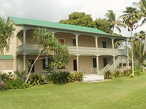
Huliheʻe Palace
Historic building in Kailua, Hawaii, U.S.
Distance: Approx. 2421 meters
Latitude and longitude: 19.63944444,-155.99444444
The Huliheʻe Palace is located in historic Kailua-Kona, Hawaiʻi, on Ali'i Drive. The former vacation home of Hawaiian royalty, it was converted to a museum run by the Daughters of Hawaiʻi, showcasing furniture and artifacts. It is located at 75–5718 Aliʻi Drive, Kailua-Kona.

Kona Hawaii Temple
Temple of The Church of Jesus Christ of Latter-day Saints
Distance: Approx. 1627 meters
Latitude and longitude: 19.64161111,-155.98552778
The Kona Hawaii Temple is the 70th operating temple of the Church of Jesus Christ of Latter-day Saints (LDS Church). The temple is located in Kailua-Kona on the island of Hawaii and is the second temple built in Hawaii, along with the Laie Hawaii Temple. It is the sixth temple built in the Pacific Islands.

St. Michael the Archangel Church (Kailua-Kona, Hawaii)
Distance: Approx. 2388 meters
Latitude and longitude: 19.63694444,-155.99111111
Saint Michael the Archangel Catholic Church is a parish of the Roman Catholic Church of Hawaiʻi in the United States. Located in Kailua-Kona on the Big Island of Hawaiʻi, 75-5769 Ali'i Drive, coordinates 19°38′13″N 155°59′28″W. The church falls under the jurisdiction of the Diocese of Honolulu and its bishop. On June 17, 1839, Kamehameha III declared religious freedom in the Kingdom in the Edict of Toleration.
Hualalai Academy
Private, college-prep school in Kona, Hawaiʻi, United States
Distance: Approx. 2397 meters
Latitude and longitude: 19.67433333,-155.984825
Hualalai Academy, was a K-12 college preparatory school, it was the first accredited private, independent, K-12 school in the Districts of North and South Kona on the Big Island of Hawaiʻi.
Sadie Seymour Botanical Gardens
Distance: Approx. 4578 meters
Latitude and longitude: 19.61375,-155.96833333
The Sadie Seymour Botanical Gardens (1.5 acres) are nonprofit botanical gardens located on the grounds of the Kona Educational Foundation Center at 76-6280 Kuakini Highway, Kailua-Kona, Hawaiʻi island, Hawaiʻi. Coordinates are 19°36′49.5″N 155°58′6″W. They are open daily; admission is free, but donations accepted. Sadie Seymour (1907–1975) founded the outdoor circle to beautify the Kona community.

Kealakehe High School
High school in Hawaiʻi
Distance: Approx. 2832 meters
Latitude and longitude: 19.67027778,-155.99805556
Kealakehe High School is a public high school located in Kailua, Hawaii County, Hawaii, United States. It has the largest geographic school attendance boundary in the state and covers a geographic district 40 miles (64 km) wide, encompassing the communities of Kailua-Kona, Hōlualoa, Waikōloa, and Puakō.
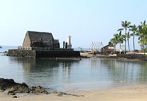
Kamakahonu
Historic Place in Hawaii County, Hawaii
Distance: Approx. 2704 meters
Latitude and longitude: 19.63900556,-155.99758611
Kamakahonu, the residence of Kamehameha I, was located at the north end of Kailua Bay in Kailua-Kona on Hawaiʻi Island.

Mokuaikaua Church
Historic Place in Kailua-Kona, Hawaii County, Hawaii
Distance: Approx. 2364 meters
Latitude and longitude: 19.6396,-155.99386667
Mokuaikaua Church, located on the "Big Island" of Hawaii, is the oldest Christian church in the Hawaiian Islands. The congregation dates to 1820 and the building was completed in 1837.
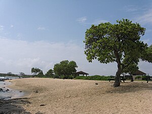
Old Kona Airport State Recreation Area
Park
Distance: Approx. 3181 meters
Latitude and longitude: 19.64247222,-156.00505556
Old Kona Airport State Recreation Area (known locally as Old A) is a park built on the site of an old landing strip just north of Kailua, Hawaii County, Hawaii.
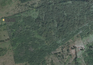
Puaʻa-2 Agricultural Fields Archeological District
United States historic place
Distance: Approx. 4035 meters
Latitude and longitude: 19.64027778,-155.94166667
Pua'a-2 Agricultural Fields Archeological District is a historic site of Ancient Hawaii agriculture on the Big Island of Hawaiʻi.
Weather in this IP's area
overcast clouds
24 Celsius
24 Celsius
22 Celsius
25 Celsius
1013 hPa
87 %
1013 hPa
993 hPa
10000 meters
0.45 m/s
1.34 m/s
281 degree
89 %
06:10:05
18:33:39