Country:
 USA
USARegion:
City:
Latitude and Longitude:
Time Zone:
Postal Code:
IP information under different IP Channel
ip-api
Country
Region
City
ASN
Time Zone
ISP
Blacklist
Proxy
Latitude
Longitude
Postal
Route
IPinfo
Country
Region
City
ASN
Time Zone
ISP
Blacklist
Proxy
Latitude
Longitude
Postal
Route
MaxMind
Country
Region
City
ASN
Time Zone
ISP
Blacklist
Proxy
Latitude
Longitude
Postal
Route
Luminati
Country
USRegion
ca
City
cityofindustry
ASN
Time Zone
America/Los_Angeles
ISP
TWC-20001-PACWEST
Latitude
Longitude
Postal
db-ip
Country
Region
City
ASN
Time Zone
ISP
Blacklist
Proxy
Latitude
Longitude
Postal
Route
ipdata
Country
Region
City
ASN
Time Zone
ISP
Blacklist
Proxy
Latitude
Longitude
Postal
Route
Popular places and events near this IP address
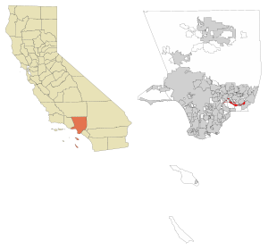
City of Industry, California
City in the United States
Distance: Approx. 2104 meters
Latitude and longitude: 34.005,-117.939
The City of Industry is a city in the San Gabriel Valley, in eastern Los Angeles County, California, United States. The city is almost entirely industrial, containing over 3,000 businesses employing 67,000 people, with only 264 residents as of the 2020 census, making it the third least populous city in the state. It was incorporated on June 18, 1957, and has become the economic hub for the San Gabriel Valley.

Hacienda Heights, California
Unincorporated community in California, United States
Distance: Approx. 773 meters
Latitude and longitude: 34.00055556,-117.96944444
Hacienda Heights () is an unincorporated suburban community in Los Angeles County, California, United States. As of the 2020 census, the community had a total population of 54,191, up from 54,038 at the 2010 census. For statistical purposes, the Census Bureau has defined Hacienda Heights as a census designated place (CDP).
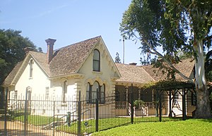
Workman and Temple Family Homestead Museum
Historic house in California, United States
Distance: Approx. 1884 meters
Latitude and longitude: 34.02,-117.96416667
The Workman and Temple Family Homestead Museum is a historic house museum located at 15415 East Don Julian Road in City of Industry, California, that features the homes and private cemetery that belonged to the pioneer Workman-Temple family.

El Campo Santo
Historic cemetery in Industry, California
Distance: Approx. 1717 meters
Latitude and longitude: 34.01861111,-117.9625
El Campo Santo is a cemetery located at the Workman and Temple Family Homestead Museum, 15415 East Don Julian Road, in City of Industry, California. As one of the oldest private cemeteries in Southern California, El Campo Santo contains the remains of the pioneering Workman-Temple family as well as Pío Pico, the last governor of Alta California, and other prominent pioneer families. Within its low brick walls, the one-half acre cemetery features a Neoclassical mausoleum and a small cemetery plot surrounded by a Gothic Revival cast-iron fence.

Los Altos High School (Hacienda Heights, California)
High school located in California, United States
Distance: Approx. 1451 meters
Latitude and longitude: 34.00769,-117.97646
Los Altos High School is a comprehensive four-year public education high school located in the bedroom community of Hacienda Heights, California, United States, in eastern Los Angeles County. It should not be confused with the Los Altos High School located in the city of Los Altos, California.
Glen A. Wilson High School
Public high school in Hacienda Heights, California, United States
Distance: Approx. 1446 meters
Latitude and longitude: 33.9987,-117.947
Glen A. Wilson High School is a public high school located in Hacienda Heights, California. It is one of two high schools located in the unincorporated community, and one of four in the Hacienda La Puente Unified School District.

La Puente Valley Woman's Club
United States historic place
Distance: Approx. 2293 meters
Latitude and longitude: 34.02194444,-117.95138889
La Puente Valley Women's Club is a women's club building located in the La Puente Downtown Business District of La Puente, in eastern Los Angeles County, California. It is a member of the General Federation of Women's Clubs.
La Puente High School
Public secondary school in La Puente, California, United States
Distance: Approx. 2483 meters
Latitude and longitude: 34.025,-117.956
La Puente High School is a public high school in La Puente, California, located in the San Gabriel Valley, serving grades 9–12. It was established in 1915. It is one of six high schools (including two alternative schools) in the Hacienda La Puente Unified School District.

Rancho La Puente
Historic ranch in Southern California, United States
Distance: Approx. 2987 meters
Latitude and longitude: 34.03,-117.96
Rancho La Puente was a ranch in the southern San Gabriel Valley that measured just under 49,000 acres (200 km2), and remained intact from its establishment in the late 1700s as an outpost of Mission San Gabriel until about 1870. By modern landmarks, the ranch extended from San Gabriel River on the west to just west of the 57 Freeway on the east and from Ramona Boulevard/San Bernardino Road on the north to the Puente Hills on the south. All but 40 acres (160,000 m2), which fall within Orange County, are within Los Angeles County.

John A. Rowland House
Historic house in California, United States
Distance: Approx. 968 meters
Latitude and longitude: 34.01083333,-117.95666667
John A. Rowland House in the City of Industry, California, was built in 1855. It was the home of pioneer John A. Rowland, a member of the Workman-Rowland party and co-leader of the first American group of settlers to reach Southern California in 1841. John A. Rowland built this home for his second wife, Charlotte M. Gray.
Awigna, California
Former settlement in California, United States
Distance: Approx. 2186 meters
Latitude and longitude: 34.02,-117.94944444
Awigna (also, Awiz-na) is a former Tongva-Gabrieleño Native American settlement located at the site of modern-day La Puente High School, in the San Gabriel Valley in Los Angeles County, California. The settlement was one of twenty seven villages included in the records of Mission San Gabriel, indicating that villagers from Awigna were baptized there after its establishment in the Los Angeles Basin in 1776. Awigna was described as "one of the principal rancherias to supply it [the mission] with neophytes." In 1915, La Puente High School was built on the village site.
Hillgrove, California
Unincorporated community in California, US
Distance: Approx. 2279 meters
Latitude and longitude: 34.01694444,-117.98
Hillgrove is an unincorporated community located in the southern San Gabriel Valley of eastern Los Angeles County, California. The population in 1960 was 14,669. A former section was a census-designated place, that became part of neighboring Hacienda Heights after the 1970 census.
Weather in this IP's area
clear sky
29 Celsius
30 Celsius
24 Celsius
33 Celsius
1008 hPa
52 %
1008 hPa
995 hPa
10000 meters
1.16 m/s
0.85 m/s
217 degree
4 %
06:30:08
19:09:33