Country:
 USA
USARegion:
City:
Latitude and Longitude:
Time Zone:
Postal Code:
IP information under different IP Channel
ip-api
Country
Region
City
ASN
Time Zone
ISP
Blacklist
Proxy
Latitude
Longitude
Postal
Route
IPinfo
Country
Region
City
ASN
Time Zone
ISP
Blacklist
Proxy
Latitude
Longitude
Postal
Route
MaxMind
Country
Region
City
ASN
Time Zone
ISP
Blacklist
Proxy
Latitude
Longitude
Postal
Route
Luminati
Country
USRegion
ca
City
santaclarita
ASN
Time Zone
America/Los_Angeles
ISP
TWC-20001-PACWEST
Latitude
Longitude
Postal
db-ip
Country
Region
City
ASN
Time Zone
ISP
Blacklist
Proxy
Latitude
Longitude
Postal
Route
ipdata
Country
Region
City
ASN
Time Zone
ISP
Blacklist
Proxy
Latitude
Longitude
Postal
Route
Popular places and events near this IP address
California Institute of the Arts
American private art school
Distance: Approx. 1097 meters
Latitude and longitude: 34.3928,-118.5673
The California Institute of the Arts (CalArts) is a private art school in Santa Clarita, California. It was incorporated in 1961 as the first degree-granting institution of higher learning in the US created specifically for students of both the visual and performing arts. It offers Bachelor of Fine Arts, Master of Fine Arts, Master of Arts, and Doctor of Musical Arts degrees through its six schools: Art, Critical Studies, Dance, Film/Video, Music, and Theater.
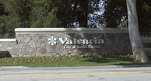
Valencia, Santa Clarita, California
Neighborhood of Santa Clarita in Los Angeles County, California
Distance: Approx. 2522 meters
Latitude and longitude: 34.42,-118.56
Valencia is a neighborhood in Santa Clarita located within Los Angeles County, California. It is one of the four unincorporated communities (along with Saugus, Newhall, and Canyon Country) that merged to create the city of Santa Clarita in 1987. It is situated in the western part of Santa Clarita, stretching from Lyons Avenue to the south (on the border with Newhall) to north of Copper Hill Drive, and from Interstate 5 east to Bouquet Canyon and Seco Canyon Roads.

College of the Canyons
Community college in Santa Clarita, California
Distance: Approx. 1291 meters
Latitude and longitude: 34.40444444,-118.56805556
College of the Canyons (COC) is a public community college in Santa Clarita, California. It comprises the Santa Clarita Community College District. The college is accredited by the Western Association of Schools and Colleges and has campus locations in Valencia and Canyon Country.
William S. Hart High School
Public high school in Santa Clarita, California, United States
Distance: Approx. 2267 meters
Latitude and longitude: 34.3845,-118.5378
William S. Hart High School is a four-year public high school in the neighborhood of Newhall in the city of Santa Clarita, California, United States. Founded in 1945, it is the oldest high school in the Santa Clarita Valley. Named for local cowboy actor William S. Hart, it is part of the William S. Hart Union High School District.
Newhall School District
School district in Santa Clarita, California
Distance: Approx. 1258 meters
Latitude and longitude: 34.3892,-118.5475
The Newhall School District is an elementary school district in the Santa Clarita Valley that serves the Valencia and Newhall communities within the city of Santa Clarita, California, as well as the Stevenson Ranch community in unincorporated Los Angeles County. It currently includes ten schools.

California State Summer School for the Arts
Summer program at the California Institute of the Arts
Distance: Approx. 1055 meters
Latitude and longitude: 34.39305556,-118.56694444
The California State Summer School for the Arts, commonly known as CSSSA ("SEE-SUH"), is a rigorous four-week, pre-professional visual and performing arts training program for high school students held each summer at the California Institute of the Arts (CalArts). The goal of CSSSA is to provide a supportive environment in which students acquire experience and training that extends beyond the practice and improvement of aesthetics and technique. Artistic disciplines offered by the program include: animation, creative writing, dance, film and video, music (including vocal arts), theatre arts, and visual arts.

Valencia Town Center
Shopping mall in Santa Clarita, California, United States
Distance: Approx. 1951 meters
Latitude and longitude: 34.415,-118.558
Valencia Town Center, formerly Westfield Valencia Town Center from 2005 to 2023, is a shopping mall in the neighborhood of Valencia in Santa Clarita, California. Centennial Realty currently owns the mall since September 1, 2023. The previous owner, Westfield Group had acquired a quarter-interest in the property in 2002 and a further quarter-interest in 2005, thereafter assuming management control.
CalArts Center for New Performance
Professional producing arm of the California Institute of the Arts
Distance: Approx. 1055 meters
Latitude and longitude: 34.39305556,-118.56694444
The CalArts Center for New Performance (CNP) is the professional producing arm of the California Institute of the Arts. Founded in 2002 by Susan Solt, Travis Preston, and Carol Bixler and launched with Travis Preston's groundbreaking all female production of King Lear, and originally called the CalArts Center for New Theater, the name was changed in 2005.
Academy of the Canyons
Public school in Santa Clarita, California, United States
Distance: Approx. 1339 meters
Latitude and longitude: 34.405,-118.5682
Academy of the Canyons (AOC) is a public middle college high school in Santa Clarita, California, United States. The school, which enrolls students from 9th to 12th grade, is part of the William S. Hart High School District. It is located on the Valencia College of the Canyons campus, where students of AOC are concurrently enrolled.
Takuyumam, California
Former Chumashan settlement in California, United States
Distance: Approx. 2777 meters
Latitude and longitude: 34.38472222,-118.53083333
Takuyumam is a former Chumashan settlement in Los Angeles County, California. Its former location is now the site of Newhall.

Henry Mayo Newhall Memorial Hospital
Hospital in Santa Clarita, California
Distance: Approx. 320 meters
Latitude and longitude: 34.39777778,-118.55333333
Henry Mayo Newhall Hospital (commonly referred to as Henry Mayo Hospital) is a 357-bed not-for-profit community hospital and trauma center in Valencia, Santa Clarita, California. It was founded in 1975. Named after businessman Henry Mayo Newhall, the hospital recently opened a new patient tower that includes 90 private patient rooms and a new Center for Women and Newborns, also with all private rooms.
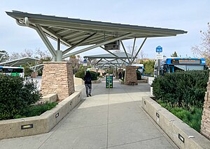
McBean Regional Transit Center
Transit center in Santa Clarita, California
Distance: Approx. 1898 meters
Latitude and longitude: 34.414,-118.562
McBean Regional Transit Center, also known by its acronym MRTC, is a transit center and bus station located at 24375 Valencia Boulevard in the Valencia area of Santa Clarita, California, near the intersection of Valencia Boulevard and McBean Parkway. It is located next to the Westfield Valencia Town Center. The facility opened on January 20, 2002, with 12 bus stands.
Weather in this IP's area
few clouds
14 Celsius
12 Celsius
10 Celsius
15 Celsius
1011 hPa
40 %
1011 hPa
966 hPa
10000 meters
1.34 m/s
1.79 m/s
27 degree
15 %
07:02:24
18:15:47