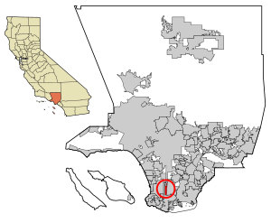
Country:
 USA
USARegion:
City:
Latitude and Longitude:
Time Zone:
Postal Code:
IP information under different IP Channel
ip-api
Country
Region
City
ASN
Time Zone
ISP
Blacklist
Proxy
Latitude
Longitude
Postal
Route
IPinfo
Country
Region
City
ASN
Time Zone
ISP
Blacklist
Proxy
Latitude
Longitude
Postal
Route
MaxMind
Country
Region
City
ASN
Time Zone
ISP
Blacklist
Proxy
Latitude
Longitude
Postal
Route
Luminati
Country
USRegion
ca
City
torrance
ASN
Time Zone
America/Los_Angeles
ISP
TWC-20001-PACWEST
Latitude
Longitude
Postal
db-ip
Country
Region
City
ASN
Time Zone
ISP
Blacklist
Proxy
Latitude
Longitude
Postal
Route
ipdata
Country
Region
City
ASN
Time Zone
ISP
Blacklist
Proxy
Latitude
Longitude
Postal
Route
Popular places and events near this IP address

South Bay (Los Angeles County)
Region in California, United States
Distance: Approx. 1761 meters
Latitude and longitude: 33.83694444,-118.31805556
The South Bay is a region of the Los Angeles metropolitan area, located in the southwest corner of Los Angeles County. The name stems from its geographic location stretching along the southern shore of Santa Monica Bay. The South Bay contains sixteen cities plus portions of the City of Los Angeles and unincorporated portions of the county.
West Carson, California
Unincorporated community in California, United States
Distance: Approx. 1702 meters
Latitude and longitude: 33.82638889,-118.2925
West Carson is an unincorporated community in the South Bay region of Los Angeles County, California. The population was 22,870 at the 2020 census. For statistical purposes, the United States Census Bureau has defined West Carson as a census-designated place (CDP).
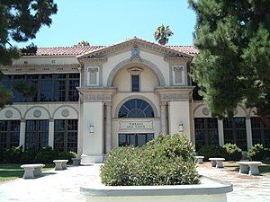
Torrance High School
Public school in Torrance, California, United States
Distance: Approx. 1255 meters
Latitude and longitude: 33.82925,-118.3211661
Torrance High School is a high school located in Torrance, California. Founded in 1917, it is one of the oldest high schools in continuous use in California and is the oldest of the five high schools in the Torrance Unified School District. Four of its buildings are listed on the U.S. National Register of Historic Places.
Harbor–UCLA Medical Center
Hospital in California, United States
Distance: Approx. 1656 meters
Latitude and longitude: 33.8298,-118.2947
Harbor–UCLA Medical Center is a 570-bed public teaching hospital located at 1000 West Carson Street in West Carson, an unincorporated area within Los Angeles County, California. The hospital is owned by Los Angeles County and operated by the Los Angeles County Department of Health Services, while doctors are faculty of the David Geffen School of Medicine at UCLA, who oversee the medical residents being trained at the facility. The facility is one of two adult level I trauma centers (providing the highest level of surgical care to trauma patients) operated by Los Angeles County; the other is Los Angeles General Medical Center.
Southern California Regional Occupational Center
Vocational school in Southern California, United States
Distance: Approx. 1581 meters
Latitude and longitude: 33.82428,-118.32726
The Southern California Regional Occupational Center or SoCal ROC is located in Torrance, California. It is a Joint Powers Authority serving 6 school districts (Inglewood, Manhattan Beach, Palos Verdes Peninsula, Redondo Beach, El Segundo, and Torrance). As of 2020, the six school districts sent less than 20 high school students each.
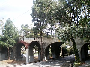
Pacific Electric Railroad Bridge
United States historic place
Distance: Approx. 1684 meters
Latitude and longitude: 33.83758333,-118.31169444
The Pacific Electric Railroad Bridge or Southern Pacific Railroad Bridge now officially named the "Pacific Electric Railway- El Prado Bridge" is a historic double-tracked arch bridge located in Torrance, California US, spanning Torrance Boulevard at Bow Avenue, a short distance west of Western Avenue. It was once part of the north/south San Pedro via Gardena Line of the Pacific Electric Railway, that agency's first interurban line to San Pedro. Torrance, California is a town that was planned on the drawing board.

Home Economics Building (Torrance High School)
United States historic place
Distance: Approx. 1385 meters
Latitude and longitude: 33.83111111,-118.32111111
The Home Economics Building is located on the campus of Torrance High School in Torrance, Los Angeles County, California. It was built in 1922–1923, in the Mediterranean Revival style. It was listed on the National Register of Historic Places in 1983.
Main Building (Torrance High School)
United States historic place
Distance: Approx. 1308 meters
Latitude and longitude: 33.83083333,-118.32027778
The Main Building of Torrance High School is located on the campus in Torrance, southwestern Los Angeles County, California. The Main Building was opened to students as Torrance School in 1917.
Torrance School
United States historic place
Distance: Approx. 967 meters
Latitude and longitude: 33.82805556,-118.31833333
The Torrance School, also known as Torrance High School Annex and originally as Torrance Elementary School, is located on the campus of Torrance High School in Torrance, southwestern Los Angeles County, California.
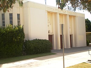
Auditorium (Torrance High School)
United States historic place
Distance: Approx. 1207 meters
Latitude and longitude: 33.83,-118.31972222
The Auditorium, also known as the Assembly Hall, is a PWA Moderne style building located on the campus of Torrance High School in Torrance, Los Angeles County, California. When built in 1924 the building was a source of pride for Torrance, and was its first large meeting hall, preceding construction of a civic center. It was damaged in the 1933 Long Beach earthquake and was rebuilt as a New Deal project.
Ambassador Christian School
Private christian high school in Torrance, California, United States
Distance: Approx. 1582 meters
Latitude and longitude: 33.82435824,-118.32726024
Ambassador Christian School (ACS), formerly Ambassador High School, is a Christian middle and high school in Torrance, California. The school was established in 2013 by Michael Barker. In 2015, a team from Ambassador High School developed an experiment about the usage of wind as a means of pollination in microgravity.

Camp Ross
US WWII army base in California
Distance: Approx. 1656 meters
Latitude and longitude: 33.8298,-118.2947
Camp Ross was a World War II base serving as a staging area (embarkation camp) under the command of the Army's Los Angeles Port of Embarkation. The camp was located in San Pedro, California and Wilmington, California. The United States Department of War leased 31.026 acres of land starting in 1942.
Weather in this IP's area
clear sky
25 Celsius
25 Celsius
23 Celsius
32 Celsius
1008 hPa
68 %
1008 hPa
1005 hPa
10000 meters
06:31:39
19:10:50