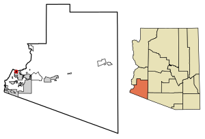
Country:
 USA
USARegion:
City:
Latitude and Longitude:
Time Zone:
Postal Code:
IP information under different IP Channel
ip-api
Country
Region
City
ASN
Time Zone
ISP
Blacklist
Proxy
Latitude
Longitude
Postal
Route
IPinfo
Country
Region
City
ASN
Time Zone
ISP
Blacklist
Proxy
Latitude
Longitude
Postal
Route
MaxMind
Country
Region
City
ASN
Time Zone
ISP
Blacklist
Proxy
Latitude
Longitude
Postal
Route
Luminati
Country
USRegion
az
City
yuma
ASN
Time Zone
America/Phoenix
ISP
TWC-20001-PACWEST
Latitude
Longitude
Postal
db-ip
Country
Region
City
ASN
Time Zone
ISP
Blacklist
Proxy
Latitude
Longitude
Postal
Route
ipdata
Country
Region
City
ASN
Time Zone
ISP
Blacklist
Proxy
Latitude
Longitude
Postal
Route
Popular places and events near this IP address

Yuma Regional Medical Center
Hospital in Yuma, Arizona
Distance: Approx. 2189 meters
Latitude and longitude: 32.6835,-114.6336
Yuma Regional Medical Center (YRMC) is a hospital in Yuma, Arizona. It began in 1958 under the name Parkview Hospital. In November 2020 during the COVID-19 pandemic, the hospital did not allow an emergency physician, Cleavon Gilman, to continue work due to his providing information on social media about the COVID-19 pandemic in Arizona.
Cibola High School (Arizona)
Public high school in Yuma, Arizona, United States
Distance: Approx. 2601 meters
Latitude and longitude: 32.692489,-114.66862
Cibola High School is a high school for the west side of Yuma, Arizona, United States. It was the third high school opened by the Yuma Union High School District upon its 1988 establishment.
Yuma High School
Public high school in Yuma, Arizona, United States
Distance: Approx. 2355 meters
Latitude and longitude: 32.718867,-114.628644
Yuma High School (often referred to simply as Yuma High) is the oldest high school in Yuma, Arizona.

KBLU (AM)
News/talk radio station in Yuma, Arizona
Distance: Approx. 2431 meters
Latitude and longitude: 32.72333333,-114.64277778
KBLU (560 kHz) is a commercial AM radio station in Yuma, Arizona. It is owned by El Dorado Broadcasters and airs a talk radio format. The studios and offices are on West 28th Street in Yuma.
Avenue B and C, Arizona
CDP in Yuma County, Arizona
Distance: Approx. 2514 meters
Latitude and longitude: 32.71916667,-114.65972222
Avenue B and C or B&C Colonia is a census-designated place (CDP) and colonia in Yuma County, Arizona, United States. The population was 4,176 at the 2010 census. Areas that are part of Avenue B and C were first subdivided in the 1920s and 1930s.

St. Paul's Episcopal Church (Yuma, Arizona)
Historic church in Arizona, United States
Distance: Approx. 2542 meters
Latitude and longitude: 32.715,-114.62111111
St. Paul's Episcopal Church is a historic church at 637 2nd Avenue in Yuma, Arizona, United States. It was built in 1909 and added to the National Register of Historic Places in 1982.
Vista High School (Arizona)
Public alternative high school in Yuma, AZ, United States
Distance: Approx. 2622 meters
Latitude and longitude: 32.684988,-114.623037
Vista Alternative High School (VAHS) is an alternative high school in Yuma, Arizona, Arizona, United States. It opened in 1991 and is part of the Yuma Union High School District. The school mascot is the Lobo.
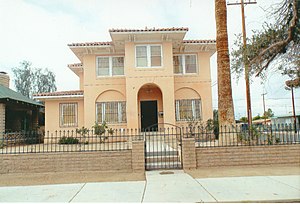
Frank Ewing House
Historic house in Arizona, United States
Distance: Approx. 2392 meters
Latitude and longitude: 32.714162,-114.622367
The Frank Ewing House is a historic house in Yuma, Arizona. It was built in 1920 for Frank L. Ewing, a businessman. The house was designed in the Spanish Colonial Revival architectural style.

J. Homer Smith House
United States historic place in Yuma County, Arizona
Distance: Approx. 2340 meters
Latitude and longitude: 32.71583333,-114.62472222
The J. Homer Smith is a historic house in Yuma, Arizona. It was built in 1917 for J. Homer Smith, a druggist and banker who served as the mayor of Yuma. He later moved to Tucson, and he died in 1936.

Ruth Ewing House
United States historic place
Distance: Approx. 2380 meters
Latitude and longitude: 32.714006,-114.622394
The Ruth Ewing House is a historic concrete block cottage in Yuma, Arizona, with a hipped roof. It was built in 1906 for Ruth Ewing, a parishioner of the St. Paul's Episcopal Church.

Brownstetter House
United States historic place
Distance: Approx. 2225 meters
Latitude and longitude: 32.71555556,-114.62611111
The Brownstetter House is a historic house in Yuma, Arizona. It was built in 1909. From 1912 to 1949, it belonged to Harry Brownstetter, "a successful merchant, real estate developer, and financier." The house was designed in the American Craftsman and the Victorian architectural styles.

Jerry Kent House
United States historic place
Distance: Approx. 2650 meters
Latitude and longitude: 32.71861111,-114.62333333
The Jerry Kent House is a historic house in Yuma, Arizona. It was built in 1905 for Jennie Kent, a schoolteacher. It was purchased by J. P. Yemen, a dentist, in 1920.
Weather in this IP's area
clear sky
43 Celsius
39 Celsius
43 Celsius
44 Celsius
1005 hPa
7 %
1005 hPa
1000 hPa
10000 meters
2.06 m/s
06:37:01
18:15:08