Country:
 USA
USARegion:
City:
Latitude and Longitude:
Time Zone:
Postal Code:
IP information under different IP Channel
ip-api
Country
Region
City
ASN
Time Zone
ISP
Blacklist
Proxy
Latitude
Longitude
Postal
Route
IPinfo
Country
Region
City
ASN
Time Zone
ISP
Blacklist
Proxy
Latitude
Longitude
Postal
Route
MaxMind
Country
Region
City
ASN
Time Zone
ISP
Blacklist
Proxy
Latitude
Longitude
Postal
Route
Luminati
Country
USRegion
ca
City
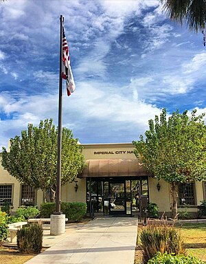
imperial
ASN
Time Zone
America/Los_Angeles
ISP
TWC-20001-PACWEST
Latitude
Longitude
Postal
db-ip
Country
Region
City
ASN
Time Zone
ISP
Blacklist
Proxy
Latitude
Longitude
Postal
Route
ipdata
Country
Region
City
ASN
Time Zone
ISP
Blacklist
Proxy
Latitude
Longitude
Postal
Route
Popular places and events near this IP address

El Centro, California
City in California, United States
Distance: Approx. 5473 meters
Latitude and longitude: 32.8,-115.56666667
El Centro (Spanish for "The Center") is a city and county seat of Imperial County, California, United States. El Centro is the most populous city in the Imperial Valley, the east anchor of the Southern California Border Region, and the core urban area and principal city of the El Centro metropolitan area which encompasses all of Imperial County. El Centro is also the most populous U.S. city to lie entirely below sea level (−42 feet or −13 meters).
Imperial, California
City in California, United States
Distance: Approx. 768 meters
Latitude and longitude: 32.8475,-115.56944444
Imperial is a city in Imperial County, California, 4 miles (6.4 km) north of El Centro. As of the 2010 census, the city had a population of 14,758. It is part of the El Centro metropolitan area.

Imperial County Airport
Municipal airport in Imperial, California, United States
Distance: Approx. 1576 meters
Latitude and longitude: 32.83416667,-115.57861111
Imperial County Airport (IATA: IPL, ICAO: KIPL, FAA LID: IPL) is a county-owned public-use airport in Imperial County, California, United States. Also known as Boley Field, it is mostly used for general aviation, but has scheduled passenger service from one commercial airline. Service is subsidized by the Essential Air Service program.

Imperial Valley College
Public community college in Imperial County, California
Distance: Approx. 7245 meters
Latitude and longitude: 32.828,-115.504
Imperial Valley College is a public community college in Imperial County, California. It was founded in 1962 and enrolls around 7,000 students per year. In April 2022, Lennor M. Johnson, Ed.D., was appointed president of the college.
KXO (AM)
Radio station in California, United States
Distance: Approx. 5519 meters
Latitude and longitude: 32.80666667,-115.54555556
KXO (1230 kHz) is a commercial AM radio station licensed to El Centro, California. It airs an oldies format and is owned by KXO, Inc. Its studios and offices are on Main Street in El Centro, along with sister station KXO-FM 107.5.

KXO-FM
Radio station in California, United States
Distance: Approx. 5519 meters
Latitude and longitude: 32.80666667,-115.54555556
KXO-FM (107.5 MHz) is a commercial radio station licensed to El Centro, California, and serving the Imperial Valley. It broadcasts an adult contemporary radio format and is owned and operated by KXO Inc., along with KXO (1230 AM). The studios and offices are on Main Street in El Centro.

Central Union High School (El Centro, California)
Secondary school in El Centro, California, United States
Distance: Approx. 6613 meters
Latitude and longitude: 32.79,-115.564
Central Union High School, also known as Central or CUHS, is a four-year public high school in El Centro, California with a diverse student body of more than 1,910 students. It is one of three schools in the Central Union High School District.

Central Union High School District
School district in California, United States
Distance: Approx. 7891 meters
Latitude and longitude: 32.78105556,-115.55091667
The Central Union High School District (CUHSD) is the district of the 3 high schools in El Centro, California — Central Union High School (CUHS), Southwest High School (SHS), and Desert Oasis High School (DOHS).
Southwest High School (El Centro, California)
Public school in El Centro, California, United States
Distance: Approx. 8057 meters
Latitude and longitude: 32.776,-115.58166389
Southwest High School (known as Southwest or SHS) is a 4 year public high school in El Centro, California that serves approximately 2,085 students to its diverse population. Southwest is one of the 3 high schools within the Central Union High School District. It has been a California Distinguished School.
Stark Field
Baseball field in El Centro, California
Distance: Approx. 7454 meters
Latitude and longitude: 32.785024,-115.551522
Stark Field is a professional-size baseball field located in El Centro, California. It played host to the El Centro Imperials minor league baseball team of the Sunset League and Southwest International League from 1947 to 1951. It has served as a practice facility for the local Mid-Valley Babe Ruth Little League teams.

Douthitt Strip
Airport in California
Distance: Approx. 7988 meters
Latitude and longitude: 32.78888889,-115.52972222
Douthitt Strip (FAA LID: 23CN) is a privately owned, private use airport located one nautical mile (2 km) east of the central business district of El Centro, a city in Imperial County, California, United States.
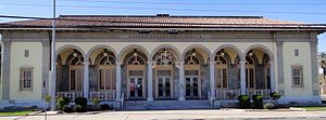
El Centro Main Post Office
United States historic post office
Distance: Approx. 6771 meters
Latitude and longitude: 32.79083333,-115.55388889
The El Centro Main Post Office, in El Centro, California, was built in 1931. It was listed on the National Register of Historic Places in 1985 as U.S. Post Office-El Centro Main. It is Beaux Arts in style, with a large loggia across the front which is common to Italianate or Second Renaissance Revival style.
Weather in this IP's area
broken clouds
38 Celsius
37 Celsius
34 Celsius
38 Celsius
1006 hPa
22 %
1006 hPa
1007 hPa
10000 meters
2.32 m/s
2.95 m/s
207 degree
63 %
06:21:20
18:59:18