Country:
 USA
USARegion:
City:
Latitude and Longitude:
Time Zone:
Postal Code:
IP information under different IP Channel
ip-api
Country
Region
City
ASN
Time Zone
ISP
Blacklist
Proxy
Latitude
Longitude
Postal
Route
IPinfo
Country
Region
City
ASN
Time Zone
ISP
Blacklist
Proxy
Latitude
Longitude
Postal
Route
MaxMind
Country
Region
City
ASN
Time Zone
ISP
Blacklist
Proxy
Latitude
Longitude
Postal
Route
Luminati
Country
USRegion
co
City
telluride
ASN
Time Zone
America/Denver
ISP
TWC-20001-PACWEST
Latitude
Longitude
Postal
db-ip
Country
Region
City
ASN
Time Zone
ISP
Blacklist
Proxy
Latitude
Longitude
Postal
Route
ipdata
Country
Region
City
ASN
Time Zone
ISP
Blacklist
Proxy
Latitude
Longitude
Postal
Route
Popular places and events near this IP address

Telluride, Colorado
Town in Colorado, United States
Distance: Approx. 569 meters
Latitude and longitude: 37.93944444,-107.81805556
Telluride is the county seat and most populous town of San Miguel County in the southwestern portion of the U.S. state of Colorado. The town is a former silver mining camp on the San Miguel River in the western San Juan Mountains. The first gold mining claim was made in the mountains above Telluride in 1875, and early settlement of what is now Telluride followed.

Mountain Village, Colorado
Town in Colorado, United States
Distance: Approx. 3635 meters
Latitude and longitude: 37.93611111,-107.86527778
Mountain Village is a home rule municipality in San Miguel County, southwestern Colorado. It is located just southwest of Telluride, Colorado in the San Juan Mountains. The elevation of the town rises above Telluride to 9,600 feet.
Uncompahgre National Forest
National Forest in western Colorado, United States
Distance: Approx. 5988 meters
Latitude and longitude: 37.983,-107.782
Uncompahgre National Forest is a U.S. National Forest covering 955,229 acres (1,492.55 sq mi, or 3,865.68 km2) in (in descending order of land area) parts of Montrose, Mesa, San Miguel, Ouray, Gunnison, Hinsdale, San Juan, and Delta Counties in western Colorado. Its headquarters are in Delta County, in the city of Delta. It borders the San Juan National Forest to the south.
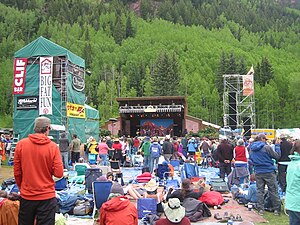
Telluride Bluegrass Festival
Distance: Approx. 1647 meters
Latitude and longitude: 37.93325,-107.80816667
Telluride Bluegrass Festival is an annual music festival in Telluride, Colorado hosted by Planet Bluegrass. Although traditionally the festival focuses on bluegrass music, it often features music from a variety of related genres.

Telluride Historic District
Historic district in Colorado, United States
Distance: Approx. 1481 meters
Latitude and longitude: 37.93722222,-107.80805556
The Telluride Historic District encompasses a significant portion of the developed area of the former mining boom town of Telluride, Colorado. Telluride was founded in 1878, and was a major metals mining center until 1913. The historic district covers 80 acres (32 ha) of downtown Telluride and surrounding residential areas, as well as Lone Tree Cemetery, the town's first cemetery.

Bridal Veil Falls (Telluride)
Waterfall in Telluride, Colorado
Distance: Approx. 5341 meters
Latitude and longitude: 37.91916667,-107.77
Bridal Veil Falls is a 365-foot (111 m) waterfall at the end of the box canyon overlooking Telluride, Colorado. Hiking and off-road trails pass by the falls and it has a hydroelectric power plant at its top. In winter the frozen shape of the falls forms an imposing challenge to intrepid ice climbers.

Smuggler-Union Hydroelectric Power Plant
United States historic place
Distance: Approx. 5429 meters
Latitude and longitude: 37.91916667,-107.76888889
The Smuggler-Union Hydroelectric Powerplant, also known as the Bridal Veil Powerhouse, is an electric power generation plant and residence located next to Bridal Veil Falls on a 400-foot (120 m) cliff overlooking Telluride, Colorado. The structure is 2+1⁄2 stories on a poured concrete foundation with a wood frame superstructure. It consists of a main power plant building, a 1+1⁄2-story residence and a 1-story cookhouse.

Pandora, Colorado
Unincorporated community in Colorado, U.S.
Distance: Approx. 3502 meters
Latitude and longitude: 37.93333333,-107.78555556
Pandora is an unincorporated community located 1.5 miles (2.4 km) east of Telluride in San Miguel County, Colorado. Pandora was founded in the 1880s as a mill town, serving as the site for mills of the Smuggler-Union, Tomboy, and Sheridan mines. The Rio Grande Southern railroad's Telluride branch terminated at the mills in Pandora.

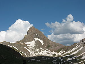
Dallas Peak
Mountain in the state of Colorado
Distance: Approx. 5260 meters
Latitude and longitude: 37.9880489,-107.8236738
Dallas Peak is a high mountain summit in the Sneffels Range of the Rocky Mountains of North America. The 13,815-foot (4,211 m) thirteener is located in the Mount Sneffels Wilderness of Uncompahgre National Forest, 3.3 miles (5.3 km) north by west (bearing 354°) of the Town of Telluride, Colorado, United States, on the drainage divide between Ouray and San Miguel counties.

Gilpin Peak
Mountain in the state of Colorado
Distance: Approx. 5792 meters
Latitude and longitude: 37.9866601,-107.7931174
Gilpin Peak is a high mountain summit in the Sneffels Range of the Rocky Mountains of North America. The 13,700-foot (4,176 m) thirteener is located in the Mount Sneffels Wilderness of Uncompahgre National Forest, 3.5 miles (5.6 km) north-northeast (bearing 23°) of the Town of Telluride, Colorado, United States, on the drainage divide between Ouray County and San Miguel County. Gilpin Peak was named in honor of William Gilpin, the first Governor of the Territory of Colorado.
Telluride School District R-1
Public school system in Colorado
Distance: Approx. 424 meters
Latitude and longitude: 37.9412,-107.8195
Telluride School District (TSD) is a public school system in San Miguel County in southwest Colorado. It consists of four schools, Telluride Elementary, Intermediate, Middle and High.

Mount Emma
Mountain in the state of Colorado
Distance: Approx. 4821 meters
Latitude and longitude: 37.9748861,-107.790415
Mount Emma is a 13,581-foot-elevation (4,139-meter) mountain summit located in San Miguel County of Colorado, United States. It is situated three miles north of the community of Telluride, on the south side of Yankee Boy Basin, in the Uncompahgre National Forest. It is part of the Sneffels Range which is a subset of the San Juan Mountains, which in turn is part of the Rocky Mountains.
Weather in this IP's area
light rain
6 Celsius
6 Celsius
6 Celsius
6 Celsius
1010 hPa
52 %
1010 hPa
734 hPa
10000 meters
1.54 m/s
11.83 m/s
290 degree
100 %
07:23:04
18:29:16