Country:
Region:
City:
Latitude and Longitude:
Time Zone:
Postal Code:
IP information under different IP Channel
ip-api
Country
Region
City
ASN
Time Zone
ISP
Blacklist
Proxy
Latitude
Longitude
Postal
Route
IPinfo
Country
Region
City
ASN
Time Zone
ISP
Blacklist
Proxy
Latitude
Longitude
Postal
Route
MaxMind
Country
Region
City
ASN
Time Zone
ISP
Blacklist
Proxy
Latitude
Longitude
Postal
Route
Luminati
Country
Region
ca
City
palmdale
ASN
Time Zone
America/Los_Angeles
ISP
TWC-20001-PACWEST
Latitude
Longitude
Postal
db-ip
Country
Region
City
ASN
Time Zone
ISP
Blacklist
Proxy
Latitude
Longitude
Postal
Route
ipdata
Country
Region
City
ASN
Time Zone
ISP
Blacklist
Proxy
Latitude
Longitude
Postal
Route
Popular places and events near this IP address

Desert View Highlands, California
Census designated place in California, United States
Distance: Approx. 7128 meters
Latitude and longitude: 34.58972222,-118.15361111
Desert View Highlands is a census-designated place (CDP) in Los Angeles County, California, United States. The population was 2,360 at the 2010 census, up from 2,337 at the 2000 census. It is surrounded by the City of Palmdale.

Leona Valley, California
Census-designated place in California, United States
Distance: Approx. 5530 meters
Latitude and longitude: 34.61833333,-118.28722222
Leona Valley (Leona, Spanish for "Lioness") is a census-designated place located in the geographic Leona Valley of northern Los Angeles County, California, in the transition between the Sierra Pelona Mountains and Mojave Desert, just west of Palmdale and the Antelope Valley. The population was 1,607 at the 2010 census. Leona Valley is best known for its agriculture, particularly cherries and wine grapes.
Antelope Valley Mall
Shopping mall in Palmdale, California
Distance: Approx. 7056 meters
Latitude and longitude: 34.60472222,-118.1525
Antelope Valley Mall is an enclosed shopping mall in Palmdale, California, in the Antelope Valley. Opened in September 1990, its buildings take up around 1 million square feet (93,000 m2). Its physical main building, parking lots, and ring road businesses encompass an area a bit less than 0.5 by 0.5 miles (800 by 800 m).
Quartz Hill High School
School in Quartz Hill, California
Distance: Approx. 6094 meters
Latitude and longitude: 34.65805556,-118.23833333
Quartz Hill High School is a public, co-educational high school located in Quartz Hill, California. Founded in 1964, it is the third oldest comprehensive high school in the Antelope Valley Union High School District.
Highland High School (Palmdale, California)
Public high school in Palmdale, California, United States
Distance: Approx. 5023 meters
Latitude and longitude: 34.59236,-118.17648
Highland High School is located in Palmdale, California and is part of the Antelope Valley Union High School District. Highland High School was founded in 1989 in response to Palmdale's rapid population growth. Palmdale High School was not large enough to serve the children of the new families moving into the Antelope Valley.
California's 25th congressional district
U.S. House district for California
Distance: Approx. 6571 meters
Latitude and longitude: 34.55,-118.2
California's 25th congressional district is a congressional district in the U.S. state of California. The district is currently represented by Democrat Raul Ruiz. The district includes all of Imperial County and parts of Riverside County and San Bernardino County.
Paraclete High School
Private Roman Catholic school in California
Distance: Approx. 6460 meters
Latitude and longitude: 34.64805556,-118.18388889
Paraclete High School is a private Roman Catholic college preparatory high school in Lancaster, California, United States, affiliated with the Roman Catholic Archdiocese of Los Angeles. It was established in 1963. On May 24, 2011, Paraclete graduated its largest class yet with the Class of 2011, reaching 203 students.

Palmdale Regional Medical Center
Hospital in California, United States
Distance: Approx. 8095 meters
Latitude and longitude: 34.585,-118.14416667
Palmdale Regional Medical Center is a private hospital located in Palmdale, California. It is one of five member hospitals of Southwest Healthcare. The facility includes a rehabilitation center, 190 acute care beds, inpatient and outpatient surgery, a primary stroke center, cardiac services, and a 24-hour emergency department.

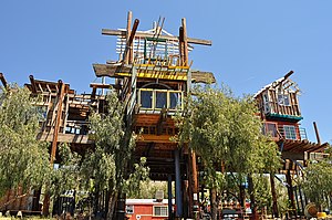
Phonehenge West
Former folk art structure in Acton, California, USA
Distance: Approx. 8848 meters
Latitude and longitude: 34.524528,-118.236563
Phonehenge West was a large folk art structure envisioned and constructed by Alan Kimble "Kim" Fahey, which included a 70-foot tower made from reclaimed material such as telephone poles, and props from old movie sets. The structure rested on his 1.7 acre property in Acton, California. The compound included 13 structures and was a representation of folk art.
Bethel Christian School (California)
School in Lancaster, California
Distance: Approx. 8739 meters
Latitude and longitude: 34.6738,-118.1863
Bethel Christian School (BCS) is a private, Baptist, Toddler-8th Grade Christian school in Lancaster, California. The school was established in 1979. At that time, the school, with 67 students and four teachers, used all of the facilities of the 4-acre (1.6 ha) church campus; the classrooms were initially located in Building 100.
SOAR High School
Public school in Lancaster, California, United States
Distance: Approx. 8972 meters
Latitude and longitude: 34.67583333,-118.18555556
Students On Academic Rise (SOAR) High School is an early college high school in Lancaster, California. The high school is a joint project of the Antelope Valley Union High School District and Antelope Valley College. SOAR stands for Students on Academic Rise.
Boiling Point, California
Unincorporated community in California, United States
Distance: Approx. 9567 meters
Latitude and longitude: 34.52221389,-118.2623
Boiling Point is an archaic placename in the Antelope Valley of the Mojave Desert, in northern Los Angeles County, California, United States The name refers to a landmark hill along the Sierra Highway, 12 mi (19 km), west of Palmdale, where "many radiators blew their stacks after a tedious climb.
Weather in this IP's area
clear sky
8 Celsius
6 Celsius
7 Celsius
11 Celsius
1014 hPa
53 %
1014 hPa
901 hPa
10000 meters
3.6 m/s
350 degree
07:01:18
18:14:16
