Country:
 USA
USARegion:
City:
Latitude and Longitude:
Time Zone:
Postal Code:
IP information under different IP Channel
ip-api
Country
Region
City
ASN
Time Zone
ISP
Blacklist
Proxy
Latitude
Longitude
Postal
Route
IPinfo
Country
Region
City
ASN
Time Zone
ISP
Blacklist
Proxy
Latitude
Longitude
Postal
Route
MaxMind
Country
Region
City
ASN
Time Zone
ISP
Blacklist
Proxy
Latitude
Longitude
Postal
Route
Luminati
Country
USRegion
ca
City
monrovia
ASN
Time Zone
America/Los_Angeles
ISP
TWC-20001-PACWEST
Latitude
Longitude
Postal
db-ip
Country
Region
City
ASN
Time Zone
ISP
Blacklist
Proxy
Latitude
Longitude
Postal
Route
ipdata
Country
Region
City
ASN
Time Zone
ISP
Blacklist
Proxy
Latitude
Longitude
Postal
Route
Popular places and events near this IP address
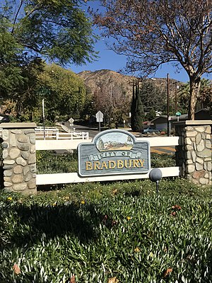
Bradbury, California
City in California, United States
Distance: Approx. 2505 meters
Latitude and longitude: 34.14944444,-117.97444444
Bradbury is a city in the San Gabriel Valley region of Los Angeles County, California, United States. It is located in the foothills of the San Gabriel Mountains below Angeles National Forest. Bradbury is bordered by the city of Monrovia to the west and south, and Duarte to the south and east.

Monrovia, California
City in California, United States
Distance: Approx. 273 meters
Latitude and longitude: 34.14591111,-118.00095
Monrovia is a city in the foothills of the San Gabriel Mountains in the San Gabriel Valley of Los Angeles County, California, United States. The population was 37,931 at the 2020 census.
World Vision International
Christian humanitarian organization
Distance: Approx. 1589 meters
Latitude and longitude: 34.14225,-118.01722222
World Vision International is an ecumenical Christian humanitarian aid, development, and advocacy organization. It was founded in 1950 by Robert Pierce as a service organization to provide care for children in Korea. In 1975, emergency and advocacy work was added to World Vision's objectives.
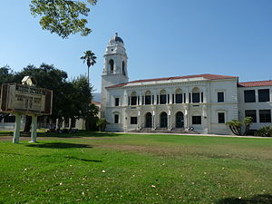
Monrovia High School
Public school in Monrovia, California, United States
Distance: Approx. 1457 meters
Latitude and longitude: 34.145766,-118.017111
Monrovia High School is a public high school located in Monrovia, California, a northeastern suburb of Los Angeles, United States. Monrovia High School is the only grades 9–12 comprehensive high school in the Monrovia Unified School District. Established in 1893, the campus is located in an environment of neo-Spanish architecture, green lawns, hundred-year-old oak trees, and is nestled against the San Gabriel Mountains.
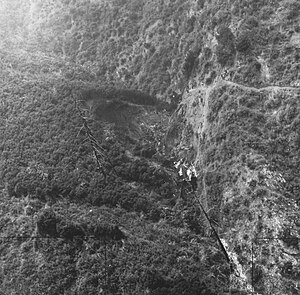
Hughes Airwest Flight 706
1971 aviation accident in Los Angeles County, California
Distance: Approx. 2976 meters
Latitude and longitude: 34.175,-118
Hughes Airwest Flight 706 was a regularly scheduled flight operated by American domestic airline Hughes Airwest from Los Angeles, California to Seattle, Washington, with several intermediate stops. On Sunday, June 6, 1971, the McDonnell Douglas DC-9 serving as Flight 706 departed Los Angeles just after 6 p.m. en route to Seattle as a McDonnell Douglas F-4 Phantom II of the United States Marine Corps was approaching Marine Corps Air Station El Toro near Irvine at the end of a flight from Naval Air Station Fallon in Nevada.
Arcadia Unified School District
School district in California, United States
Distance: Approx. 2324 meters
Latitude and longitude: 34.15345,-118.02605
The Arcadia Unified School District (AUSD) is a school district located in Arcadia, California. The district consists of six elementary schools: Holly Avenue, Longley Way, Baldwin Stocker, Camino Grove, Highland Oaks, and Hugo Reid; three middle schools: Richard Henry Dana Middle School, Foothills Middle School, and First Avenue Middle School; and one high school: Arcadia High School.

Upton Sinclair House
Historic house in California, United States
Distance: Approx. 1557 meters
Latitude and longitude: 34.16222222,-118
The Upton Sinclair House is a historic house at 464 N. Myrtle Avenue, Monrovia, California. Built in 1923, it was the home of American novelist Upton Sinclair (1878–1968) between 1942 and 1966, and is where he wrote many of his later works. It was listed on the National Register of Historic Places and was declared a National Historic Landmark in 1971.

Aztec Hotel
United States historic place
Distance: Approx. 488 meters
Latitude and longitude: 34.15166667,-118.005
The Aztec Hotel is a historical landmark building in Monrovia, in the San Gabriel Valley, California. The hotel is an example of Mayan Revival architecture still in existence. It was designed by architect Robert Stacy-Judd, and built on U.S. Route 66 in 1925-26.

The Oaks (Monrovia, California)
Historic house in California, United States
Distance: Approx. 876 meters
Latitude and longitude: 34.15608333,-118.00297222
The Oaks, also known as William N. Monroe House, is a Stick/Eastlake Queen Anne Style house that was built in 1885. It is located in the San Gabriel Valley, in Monrovia, California.

Arcadia station
Los Angeles Metro Rail station
Distance: Approx. 2588 meters
Latitude and longitude: 34.1425,-118.0288
Arcadia station is an at-grade light rail station on the A Line of the Los Angeles Metro Rail system. It is located at the intersection of 1st Avenue and Santa Clara Street in Arcadia, California, after which the station is named. This station opened on March 5, 2016, as part of Phase 2A of the Gold Line Foothill Extension Project.

Monrovia station
Los Angeles Metro Rail station
Distance: Approx. 1697 meters
Latitude and longitude: 34.13312,-118.0033
Monrovia station is an at-grade light rail station on the A Line of the Los Angeles Metro Rail system. It is located at the intersection of Duarte Road and Myrtle Avenue in Monrovia, California, after which the station is named. This station opened on March 5, 2016, as part of Phase 2A of the Gold Line Foothill Extension Project.

Monrovia Airport, California
Airport in California, US, 1928 to 1952
Distance: Approx. 1651 meters
Latitude and longitude: 34.137,-117.99
Monrovia Airport, also called the Foothill Flying Field, was an American airport in Monrovia, California active from 1928 to 1952.
Weather in this IP's area
clear sky
29 Celsius
29 Celsius
24 Celsius
32 Celsius
1010 hPa
43 %
1010 hPa
990 hPa
10000 meters
1.04 m/s
1.76 m/s
26 degree
2 %
06:30:12
19:09:48