Country:
 USA
USARegion:
City:
Latitude and Longitude:
Time Zone:
Postal Code:
IP information under different IP Channel
ip-api
Country
Region
City
ASN
Time Zone
ISP
Blacklist
Proxy
Latitude
Longitude
Postal
Route
IPinfo
Country
Region
City
ASN
Time Zone
ISP
Blacklist
Proxy
Latitude
Longitude
Postal
Route
MaxMind
Country
Region
City
ASN
Time Zone
ISP
Blacklist
Proxy
Latitude
Longitude
Postal
Route
Luminati
Country
USRegion
ca
City
losangeles
ASN
Time Zone
America/Los_Angeles
ISP
TWC-20001-PACWEST
Latitude
Longitude
Postal
db-ip
Country
Region
City
ASN
Time Zone
ISP
Blacklist
Proxy
Latitude
Longitude
Postal
Route
ipdata
Country
Region
City
ASN
Time Zone
ISP
Blacklist
Proxy
Latitude
Longitude
Postal
Route
Popular places and events near this IP address

South Park, Los Angeles
Neighborhood of Los Angeles in California, United States
Distance: Approx. 1196 meters
Latitude and longitude: 33.99833333,-118.27388889
South Park is a 1.41 square miles (3.65 km2) neighborhood within the South Los Angeles region of Los Angeles, California.

Vermont Square, Los Angeles
Neighborhood of Los Angeles in California, United States
Distance: Approx. 842 meters
Latitude and longitude: 33.999846,-118.2959017
Vermont Square is a neighborhood in Los Angeles, California, within the South Los Angeles region. The Vermont Square Branch library, a designated Historic–Cultural Monument, is located in the community.

Manual Arts High School
Secondary public school in Los Angeles, California, U.S.
Distance: Approx. 1118 meters
Latitude and longitude: 34.0083,-118.29217
Manual Arts High School is a secondary public school in Los Angeles, California, United States.
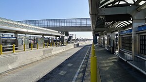
Slauson station (J Line)
Bus rapid transit station in Los Angeles, California
Distance: Approx. 1272 meters
Latitude and longitude: 33.98915,-118.28046
Slauson station is a busway station located in Los Angeles, California. It is situated between the 37th Street/USC and Manchester stations on the J Line, a bus rapid transit route which runs between El Monte, Downtown Los Angeles and San Pedro as part of the Metro Busway system. The station consists of two side platforms in the center of Interstate 110 above Slauson Avenue.

Moneta Branch
United States historic place
Distance: Approx. 1031 meters
Latitude and longitude: 34.00583333,-118.27888889
Moneta Branch, also known as the Junipero Serra Branch, is a former branch library of the Los Angeles Public Library located south of Downtown Los Angeles.
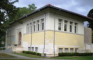
Vermont Square Branch Library
United States historic place
Distance: Approx. 758 meters
Latitude and longitude: 33.99972222,-118.295
Vermont Square Branch Library is the oldest branch library in the Los Angeles Public Library system. Located about a mile southwest of the University of Southern California campus, in the Vermont Square district, it was built in 1913 with a grant from Andrew Carnegie. One of three surviving Carnegie libraries in Los Angeles, it has been designated a Historic-Cultural Monument and listed on the National Register of Historic Places.
St. Cecilia Catholic Church (Los Angeles)
Church in California, USA
Distance: Approx. 1381 meters
Latitude and longitude: 34.00555556,-118.29972222
St. Cecilia's Catholic Church is a Roman Catholic parish in the Our Lady of the Angels Pastoral Region of the Archdiocese of Los Angeles. The church is located at 4230 South Normandie Avenue in the South Los Angeles section of Los Angeles, California USA. The Lombard Romanesque church was built in 1927.
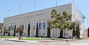
LA84 Foundation/John C. Argue Swim Stadium
Aquatics center in California, US
Distance: Approx. 1468 meters
Latitude and longitude: 34.01229,-118.28951
The LA84 Foundation/John C. Argue Swim Stadium (originally the Los Angeles Swimming Stadium) is an aquatics center that was originally constructed for the 1932 Summer Olympics in Los Angeles, California. Located near the Los Angeles Memorial Coliseum, the venue hosted the diving, swimming, water polo, and the swimming part of the modern pentathlon events. The venue originally seated 10,000 people, including 5,000 in wooden bleacher seats that were removed after the 1932 games.
Vermont-Slauson, Los Angeles
Neighborhood of Los Angeles in California, United States
Distance: Approx. 1226 meters
Latitude and longitude: 33.988995,-118.291492
Vermont-Slauson is a 1.44-square-mile neighborhood within the South Los Angeles region of Los Angeles, California.
Augustus F. Hawkins High School
Public school
Distance: Approx. 1479 meters
Latitude and longitude: 33.986057,-118.288138
Hawkins High School is part of the largest school construction building program in the history of Los Angeles Unified School District. The school consists of three Small Learning Communities (CHAS, RISE, and C:\DAGS). This school opened in the year of 2012 with the first graduating class in 2014.

BMO Stadium
Soccer stadium in Los Angeles
Distance: Approx. 1534 meters
Latitude and longitude: 34.013,-118.285
BMO Stadium, formerly Banc of California Stadium, is a soccer-specific stadium in the Exposition Park neighborhood of Los Angeles, California. It is the home of Major League Soccer's Los Angeles FC and the National Women's Soccer League's Angel City FC. Opened on April 18, 2018, it was the first open-air stadium built in the City of Los Angeles since Dodger Stadium in 1962. Constructed on the site of the former Los Angeles Memorial Sports Arena, it is located next to the Los Angeles Memorial Coliseum and just south of the main campus of the University of Southern California.
Vermont Square Park
Urban park in Los Angeles
Distance: Approx. 966 meters
Latitude and longitude: 34.0003,-118.2972
Vermont Square Park is an urban park located in Los Angeles City Council District 9, Los Angeles, California. It features barbecue pits, basketball courts, and a children's playground.
Weather in this IP's area
clear sky
27 Celsius
28 Celsius
24 Celsius
32 Celsius
1008 hPa
58 %
1008 hPa
1002 hPa
10000 meters
3.09 m/s
270 degree
06:31:27
19:10:51