Country:
 USA
USARegion:
City:
Latitude and Longitude:
Time Zone:
Postal Code:
IP information under different IP Channel
ip-api
Country
Region
City
ASN
Time Zone
ISP
Blacklist
Proxy
Latitude
Longitude
Postal
Route
IPinfo
Country
Region
City
ASN
Time Zone
ISP
Blacklist
Proxy
Latitude
Longitude
Postal
Route
MaxMind
Country
Region
City
ASN
Time Zone
ISP
Blacklist
Proxy
Latitude
Longitude
Postal
Route
Luminati
Country
USRegion
ca
City
indio
ASN
Time Zone
America/Los_Angeles
ISP
TWC-20001-PACWEST
Latitude
Longitude
Postal
db-ip
Country
Region
City
ASN
Time Zone
ISP
Blacklist
Proxy
Latitude
Longitude
Postal
Route
ipdata
Country
Region
City
ASN
Time Zone
ISP
Blacklist
Proxy
Latitude
Longitude
Postal
Route
Popular places and events near this IP address

Indio, California
City in California, United States
Distance: Approx. 157 meters
Latitude and longitude: 33.72055556,-116.21555556
Indio (Spanish for "Indian") is a city in Riverside County, California, United States, in the Coachella Valley of Southern California's Colorado Desert region. Indio is approximately 125 miles (201 km) east of Los Angeles, 23 miles (37 km) east of Palm Springs, and 98 miles (158 km) west of Blythe. The population was 89,137 in the 2020 United States Census, up from 76,036 at the 2010 census, an increase of 17%.

Coachella Valley
Valley in Southern California
Distance: Approx. 2820 meters
Latitude and longitude: 33.7,-116.2
The Coachella Valley ( koh-CHEL-ə, KOH-ə-) is an arid rift valley in the Colorado Desert of Southern California in Riverside County. The valley has been referred to as Greater Palm Springs and occasionally the Palm Springs Area due to the historic prominence of the city of Palm Springs. The valley extends approximately 45 mi (72 km) southeast from the San Gorgonio Pass to the northern shore of the Salton Sea and the neighboring Imperial Valley, and is approximately 15 mi (24 km) wide along most of its length.

Shields Date Gardens
Distance: Approx. 4864 meters
Latitude and longitude: 33.707,-116.267
Shields Date Garden is a historic date palm orchard and tourist attraction in Indio, California, United States.

Indio High School
Public school
Distance: Approx. 2308 meters
Latitude and longitude: 33.71305556,-116.24027778
Indio High School is a public high school for grades 9–12. It is located in Indio, California and has a current enrollment of about 2,090 students. Its mascot is a Rajah (an Indian prince).

Riverside County Fair and National Date Festival
Distance: Approx. 1068 meters
Latitude and longitude: 33.7125,-116.22277778
The Riverside County Fair and National Date Festival takes place in Indio, California. Since 1947 the annual festival has been held to celebrate the Date Palm harvest in the Coachella Valley. The event is held in February on the Riverside County Fairgrounds.

Spotlight 29 Casino
Distance: Approx. 3351 meters
Latitude and longitude: 33.7106,-116.1832
Spotlight 29 Casino is an Indian casino in Coachella, California, owned and operated by the Twenty-Nine Palms Band of Mission Indians of California. The casino is 250,000 square feet, with 1,600 slot machines and 22 table games. Amenities include two restaurants, food court, three bars and the Spotlight Showroom, which seats 2,200.
KESQ (AM)
Radio station in Indio, California (1946–2023)
Distance: Approx. 3362 meters
Latitude and longitude: 33.72694444,-116.25277778
KESQ (1400 AM) was a radio station broadcasting a Spanish music format licensed to Indio, California, United States. The station was a simulcast of KUNA-FM 96.7. KESQ was owned by the News-Press & Gazette Company, through its Gulf-California Broadcast Company subsidiary.
Fantasy Springs Resort Casino
Casino and hotel in Palm Springs, California
Distance: Approx. 2139 meters
Latitude and longitude: 33.7209,-116.1941
Fantasy Springs Resort Casino is a casino and hotel located southeast of Palm Springs near I-10 in Indio, California. It is owned and operated by the Cabazon Band of Cahuilla Indians, a federally recognized tribe. The hotel has 250 rooms and the casino consists of 1800 slot machines and video poker, 40 tables and 100,000 sq ft (9,300 m2) of special events center space.
Terra Lago
Gated community in Riverside County, California
Distance: Approx. 3615 meters
Latitude and longitude: 33.74055556,-116.18611111
Terra Lago, Indio is a gated community located in Riverside County, California, of the Coachella Valley, approximately 25 miles (40 km) east of Palm Springs. Its address is 42-900 Lago Vista, 92203 Indio, California. The community is inside area codes 442 and 760.
John F. Kennedy Memorial Hospital
Hospital in California, United States
Distance: Approx. 2345 meters
Latitude and longitude: 33.70638889,-116.23555556
John F. Kennedy Memorial Hospital is a Tenet Healthcare owned hospital in Indio, California, United States.

Empire Polo Club
Polo club in Indio, California
Distance: Approx. 4937 meters
Latitude and longitude: 33.679811,-116.237256
The Empire Polo Club is a 1000-acre (32 ha) polo club in Indio, California, in the Coachella Valley of Riverside County, approximately 22 miles southeast of Palm Springs. Founded in 1987, it has hosted international polo tournaments. It leases out its polo grounds for Coachella Valley Music and Arts Festival and Stagecoach Festival annually for the last three weekends in April.
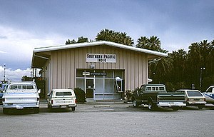
Indio station
Train station in Indio, California, United States
Distance: Approx. 133 meters
Latitude and longitude: 33.721023,-116.215774
Indio is a former and future train station in Indio, California. Rail service began on May 29, 1876, by the Southern Pacific. The station was a stop on the transcontinental Sunset Limited; that service was commuted to Amtrak in 1971.
Weather in this IP's area
clear sky
20 Celsius
19 Celsius
17 Celsius
21 Celsius
1007 hPa
51 %
1007 hPa
1007 hPa
10000 meters
3.13 m/s
8.05 m/s
334 degree
06:52:23
18:07:05