Country:
 USA
USARegion:
City:
Latitude and Longitude:
Time Zone:
Postal Code:
IP information under different IP Channel
ip-api
Country
Region
City
ASN
Time Zone
ISP
Blacklist
Proxy
Latitude
Longitude
Postal
Route
IPinfo
Country
Region
City
ASN
Time Zone
ISP
Blacklist
Proxy
Latitude
Longitude
Postal
Route
MaxMind
Country
Region
City
ASN
Time Zone
ISP
Blacklist
Proxy
Latitude
Longitude
Postal
Route
Luminati
Country
USRegion
ca
City
deserthotsprings
ASN
Time Zone
America/Los_Angeles
ISP
TWC-20001-PACWEST
Latitude
Longitude
Postal
db-ip
Country
Region
City
ASN
Time Zone
ISP
Blacklist
Proxy
Latitude
Longitude
Postal
Route
ipdata
Country
Region
City
ASN
Time Zone
ISP
Blacklist
Proxy
Latitude
Longitude
Postal
Route
Popular places and events near this IP address

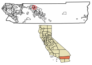
Desert Hot Springs, California
City in California, United States
Distance: Approx. 2295 meters
Latitude and longitude: 33.96111111,-116.50166667
Desert Hot Springs is a city in Riverside County, California, United States. The city is located within the Coachella Valley geographic region. The population was 32,512 as of the 2020 census, up from 25,938 at the 2010 census.

Big Morongo Canyon Preserve
Distance: Approx. 4990 meters
Latitude and longitude: 34.00138889,-116.55861111
The Big Morongo Canyon Preserve is a 31,000-acres (130 km2) native plants habitat and wildlife preserve located in the Little San Bernardino Mountains of the Transverse Ranges, in the transition zone between the higher Mojave Desert and lower elevation Colorado Desert section of the Sonoran Desert. Due to its location within this transition zone, the area is especially high in natural diversity. The natural spring fed desert oasis found here is one of the 10 largest Cottonwood (Populus fremontii) and Willow (Salix lasiolepis) riparian habitats in California.
North Palm Springs, California
Unincorporated community in California, United States
Distance: Approx. 5034 meters
Latitude and longitude: 33.92277778,-116.54305556
North Palm Springs is an unincorporated community in Riverside County, California, United States. North Palm Springs is located at the intersection of Dillon Road and North Indian Canyon Drive near the northern border of Palm Springs, south of Interstate 10.
Garnet, California
Census-designated place in California, United States
Distance: Approx. 6190 meters
Latitude and longitude: 33.91888889,-116.48972222
Garnet is a census-designated place in Riverside County, California. Garnet sits at an elevation of 797 feet (243 m). The 2010 United States census reported Garnet's population was 7,543.
Desert Hot Springs High School
Public school in the United States
Distance: Approx. 884 meters
Latitude and longitude: 33.96361111,-116.51666667
Desert Hot Springs High School, also abbreviated as DHSHS, is a public high school for grades 9–12. It is located in Desert Hot Springs, California. The school is one of four comprehensive high schools in the Palm Springs Unified School District.

Palm Springs station
Train station in Palm Springs, California, US
Distance: Approx. 7833 meters
Latitude and longitude: 33.89777778,-116.54805556
Palm Springs station is an Amtrak train station in the Garnet community of Palm Springs, California, United States. The station is served by the thrice-weekly round trip of the combined Sunset Limited/Texas Eagle. The station has a single side platform and an open-air shelter.
Nude Bowl
Skateboarding area in California, US
Distance: Approx. 8705 meters
Latitude and longitude: 33.967504,-116.620163
The Nude Bowl was a popular skateboarding locale from the late 1970s to the early 1990s. The name comes from the fact that the site was once a naturist resort named "Desert Gardens Ranch." It is outside Desert Hot Springs, California and consists of an abandoned kidney bean shaped swimming pool and a few foundations of buildings that used to surround the area. There is no paved road to the Nude Bowl.
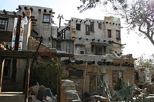
Cabot's Pueblo Museum
Museum in Desert Hot Springs, California
Distance: Approx. 4122 meters
Latitude and longitude: 33.95805556,-116.48222222
Cabot's Pueblo Museum is an American historic house museum located in Desert Hot Springs, California, and built by Cabot Yerxa, an early pioneer of the Colorado Desert. A large, Hopi-style pueblo, built in the Pueblo Revival Style, it contains artworks, artifacts of American Indian and Alaska Native cultures, and memorabilia of early desert homesteader life. The museum may also be referred to as Cabot's Old Indian Pueblo Museum, Cabot's Trading Post or Yerxa's Discovery.
2016 I-10 tour bus crash
2016 bus incident in California, United States
Distance: Approx. 7200 meters
Latitude and longitude: 33.905066,-116.553027
The 2016 I-10 tour bus crash was a vehicle accident that occurred on Interstate 10 (I-10) in California on October 23, 2016, when a tour bus slammed into the back of a semi-trailer truck. The crash killed 13 and injured 30 others.
B Bar H Ranch, California
Unincorporated community in California, United States
Distance: Approx. 7385 meters
Latitude and longitude: 33.91027778,-116.48194444
B Bar H Ranch, California is an unincorporated area with cultural and historical features and is a residential community in Riverside County, California. B Bar H Ranch is located between Palm Springs and Desert Hot Springs in the Seven Palms Valley. California Home Town Locator states the B Bar H Ranch Latitude is 33.9102927 and Longitude is -116.4819566.

Desert Hot Springs (thermal mineral springs)
Thermal springs in Riverside County, California
Distance: Approx. 1725 meters
Latitude and longitude: 33.96111111,-116.50805556
Desert Hot Springs is a geothermal geographic area in Riverside County, California with several hot springs. Since 1941, the California Department of Conservation has recorded approximately 200 geothermal wells (with temperatures below 212 °F) that have been drilled in this geographic area; approximately 50 of which are used for commercial spas and pools.
1992 Joshua Tree earthquake
Distance: Approx. 7031 meters
Latitude and longitude: 33.91,-116.49
The 1992 Joshua Tree earthquake occurred at 9:50:25 p.m. PDT (04:50:25 UTC) on April 22 in Southern California. The magnitude 6.2 earthquake struck under the Little San Bernardino Mountains, near the town of Joshua Tree, California.
Weather in this IP's area
clear sky
21 Celsius
21 Celsius
17 Celsius
23 Celsius
1010 hPa
55 %
1010 hPa
970 hPa
10000 meters
3.07 m/s
3.31 m/s
280 degree
06:32:31
18:46:56