Country:
 USA
USARegion:
City:
Latitude and Longitude:
Time Zone:
Postal Code:
IP information under different IP Channel
ip-api
Country
Region
City
ASN
Time Zone
ISP
Blacklist
Proxy
Latitude
Longitude
Postal
Route
IPinfo
Country
Region
City
ASN
Time Zone
ISP
Blacklist
Proxy
Latitude
Longitude
Postal
Route
MaxMind
Country
Region
City
ASN
Time Zone
ISP
Blacklist
Proxy
Latitude
Longitude
Postal
Route
Luminati
Country
USRegion
tx
City
spring
ASN
Time Zone
America/Chicago
ISP
ATGS-MMD-AS
Latitude
Longitude
Postal
db-ip
Country
Region
City
ASN
Time Zone
ISP
Blacklist
Proxy
Latitude
Longitude
Postal
Route
ipdata
Country
Region
City
ASN
Time Zone
ISP
Blacklist
Proxy
Latitude
Longitude
Postal
Route
Popular places and events near this IP address

PARC (company)
American company
Distance: Approx. 1028 meters
Latitude and longitude: 37.40277778,-122.14861111
SRI Future Concepts Division (formerly Palo Alto Research Center, PARC and Xerox PARC) is a research and development company in Palo Alto, California. It was founded in 1969 by Jacob E. "Jack" Goldman, chief scientist of Xerox Corporation, as a division of Xerox, tasked with creating computer technology-related products and hardware systems. Xerox PARC has been foundational to numerous revolutionary computer developments, including laser printing, Ethernet, the modern personal computer, GUI (graphical user interface) and desktop paradigm, object-oriented programming, ubiquitous computing, electronic paper, a-Si (amorphous silicon) applications, the computer mouse, and VLSI (very-large-scale integration) for semiconductors.

VMware
Multi-cloud service provider for all apps
Distance: Approx. 1141 meters
Latitude and longitude: 37.4021124,-122.1445973
VMware LLC is an American cloud computing and virtualization technology company headquartered in Palo Alto, California. VMware was the first commercially successful company to virtualize the x86 architecture. VMware's desktop software runs on Microsoft Windows, Linux, and macOS. VMware ESXi, its enterprise software hypervisor, is an operating system that runs on server hardware.

Stanford Research Park
Technology park in Palo Alto
Distance: Approx. 660 meters
Latitude and longitude: 37.4069,-122.1518
Stanford Research Park (SRP) is a technology park established in 1951 as a joint initiative between Stanford University and the City of Palo Alto. It was the world's first university research park. It has more than 150 companies, including Hewlett-Packard, Tesla Motors, TIBCO and VMware; previous high-profile tenants include Steve Jobs's NeXT Computer, Xerox PARC, and Facebook.

Gunn High School
High school in Palo Alto, California, United States
Distance: Approx. 1614 meters
Latitude and longitude: 37.4027,-122.134
Henry M. Gunn Senior High School is one of two public high schools in Palo Alto, California, the other being Palo Alto High School. Established in 1964 (1964), Gunn High School was named after Henry Martin Gunn, who served as the Palo Alto superintendent from 1950 to 1961. In 1964, the Palo Alto Unified School District announced that it would name the district's third high school after him.
Printers Inc. Bookstore
Distance: Approx. 1744 meters
Latitude and longitude: 37.4274,-122.1444
Printers Inc. Bookstore (1978–2001) was an independent bookstore in Palo Alto and Mountain View, California, that closed in 2001. Printers Inc is referenced in sonnets 8.13-8.16 of Vikram Seth's 1986 novel, The Golden Gate.
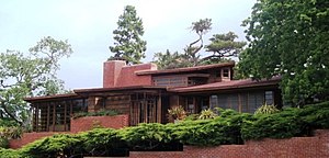
Hanna–Honeycomb House
Historic house in California, United States
Distance: Approx. 1446 meters
Latitude and longitude: 37.41601389,-122.16355278
The Hanna–Honeycomb House, also known as simply the Hanna House, located on the Stanford University campus in Stanford, California, United States, was Frank Lloyd Wright's first work in the Bay Area and his first work with non-rectangular structures. The house was chosen by the American Institute of Architects as one of seventeen buildings by the architect to be retained as an example of his contribution to American culture. It was recognized as a National Historic Landmark on June 29, 1989.

Mayfield Brewery
Brewery in Mayfield, California
Distance: Approx. 1738 meters
Latitude and longitude: 37.42722222,-122.14361111
The Mayfield Brewery also known as the Mayfield Railroad Brewery was a brewery that operated in Mayfield, California, for over 50 years, between 1868 and 1920. The brewery was located at what is now the corner of California Avenue and Birch Street in Palo Alto, California. It produced steam beer and sold it in kegs to local saloons.

Hewlett-Packard
American information technology company (1939–2015)
Distance: Approx. 312 meters
Latitude and longitude: 37.4136,-122.1451
The Hewlett-Packard Company, commonly shortened to Hewlett-Packard ( HYEW-lit PAK-ərd) or HP, was an American multinational information technology company headquartered in Palo Alto, California. HP developed and provided a wide variety of hardware components, as well as software and related services to consumers, small and medium-sized businesses (SMBs), and fairly large companies, including customers in government, health, and education sectors. The company was founded in a one-car garage in Palo Alto by Bill Hewlett and David Packard in 1939, and initially produced a line of electronic test and measurement equipment.
Rancho Rincon de San Francisquito
Mexican land grant in California
Distance: Approx. 1137 meters
Latitude and longitude: 37.42,-122.14
Rancho Rincon de San Francisquito was a 8,418-acre (34.07 km2) Mexican land grant in present-day Santa Clara County, California given in 1841 by Governor Juan Alvarado to José Peña. The name means "corner or bend of the San Francisquito" referring to San Francisquito Creek. The grant extended along Matadero Creek to the hills and included the southern part of present-day Palo Alto and the southern part of the Stanford University campus.

Kee House (Palo Alto, California)
Historic house in California, United States
Distance: Approx. 1399 meters
Latitude and longitude: 37.42455556,-122.14744444
The Kee House is a historic house located at 2310 Yale St. in Palo Alto, California. Built in 1889, it is one of the oldest houses in Palo Alto and the oldest surviving building from Mayfield, a village that predated Palo Alto and was later annexed into the city.
HP Inc.
American information technology corporation
Distance: Approx. 95 meters
Latitude and longitude: 37.4111842,-122.1476929
HP Inc. is an American multinational information technology company headquartered in Palo Alto, California, that develops personal computers (PCs), printers and related supplies, as well as 3D printing services. It was formed on November 1, 2015, as the legal successor of the original Hewlett-Packard after the company's enterprise product and business services divisions were spun off as a new publicly traded company, Hewlett Packard Enterprise.

Mayfield, California
Town in Santa Clara County, California, United States
Distance: Approx. 1600 meters
Latitude and longitude: 37.41583333,-122.13055556
Mayfield was a historic town in Santa Clara County, California. It was one of the oldest towns, predating the establishment of nearby Palo Alto and Stanford University. In 1853, prior to its becoming a town, Elisha Oscar Crosby acquired a 250 acres (1.0 km2) parcel of land, which was named Mayfield Farm.
Weather in this IP's area
overcast clouds
16 Celsius
15 Celsius
13 Celsius
17 Celsius
1013 hPa
85 %
1013 hPa
1008 hPa
10000 meters
2.57 m/s
100 %
06:55:14
19:08:28