192.56.206.232 - IP Lookup: Free IP Address Lookup, Postal Code Lookup, IP Location Lookup, IP ASN, Public IP
Country:
Region:
City:
Location:
Time Zone:
Postal Code:
IP information under different IP Channel
ip-api
Country
Region
City
ASN
Time Zone
ISP
Blacklist
Proxy
Latitude
Longitude
Postal
Route
Luminati
Country
Region
gp
City
johannesburg
ASN
Time Zone
Africa/Johannesburg
ISP
ATGS-MMD-AS
Latitude
Longitude
Postal
IPinfo
Country
Region
City
ASN
Time Zone
ISP
Blacklist
Proxy
Latitude
Longitude
Postal
Route
IP2Location
192.56.206.232Country
Region
gauteng
City
johannesburg
Time Zone
Africa/Johannesburg
ISP
Language
User-Agent
Latitude
Longitude
Postal
db-ip
Country
Region
City
ASN
Time Zone
ISP
Blacklist
Proxy
Latitude
Longitude
Postal
Route
ipdata
Country
Region
City
ASN
Time Zone
ISP
Blacklist
Proxy
Latitude
Longitude
Postal
Route
Popular places and events near this IP address

Witwatersrand
Ridge of erosion-resistant rock in South Africa
Distance: Approx. 177 meters
Latitude and longitude: -26.20361111,28.04277778
The Witwatersrand (UK: , US also ; Afrikaans pronunciation: [ˌvətˌvɑːtəɾsˈɾant]; locally the Rand or, less commonly, the Reef) is a 56-kilometre-long (35 mi), north-facing scarp in South Africa. It consists of a hard, erosion-resistant quartzite metamorphic rock, over which several north-flowing rivers form waterfalls, which account for the name Witwatersrand, meaning 'white water ridge' in Afrikaans. This east-west-running scarp can be traced with only one short gap, from Bedfordview (about 10 km [6.2 mi] west of O.R. Tambo International Airport) in the east, through Johannesburg and Roodepoort, to Krugersdorp in the west (see the diagram at left below).
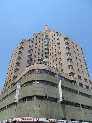
Ansteys Building
Art deco building in Johannesburg, South Africa
Distance: Approx. 106 meters
Latitude and longitude: -26.201885,28.042595
Anstey's Building is an art deco building in the city of Johannesburg. The building took its name from the original owner of the building, Norman Anstey, founder of one of the best known department stores in the city (and mayor from 1913 to 1915). The Norman Anstey and Company department store was housed in the four-storey podium of the building, which features a curved facade to address the street corner.
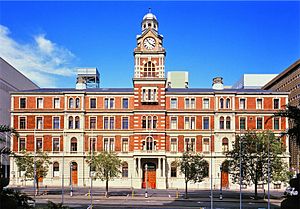
Rissik Street Post Office
National monument in Johannesburg, South Africa
Distance: Approx. 271 meters
Latitude and longitude: -26.20431,28.04225
The Rissik Street Post Office was built in 1897 during the time of Paul Kruger. Built and designed by President Paul Kruger's architect Sytze Wierda the Post Office was at one time the tallest building in Johannesburg, with a height of 102 metres (334.64 ft). The Post Office became a national monument in 1978, and it remained in operation until 1996 when the South African Post Office vacated the building.
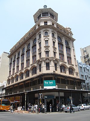
Cuthberts Building
Business-use in Johannesburg, South Africa
Distance: Approx. 112 meters
Latitude and longitude: -26.2032,28.0435
The Cuthberts Building is a Victorian style building found in the city of Johannesburg. The building was designed by architects Stucke & Bannister. Construction of the building began in 1903 and completed in 1904.

Johannesburg Trades Hall
Building in Johannesburg
Distance: Approx. 271 meters
Latitude and longitude: -26.20431,28.04225
The Trades Hall is one of the oldest Edwardian buildings in the city of Johannesburg. Beyond its architectural importance, the building has historical significance as the previous headquarters of the Trade Unions. It is associated with many historical events such as the 1922 Rand Revolt.
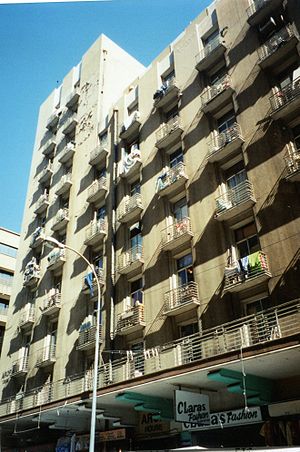
Arop House
Building in Johannesburg, South Africa
Distance: Approx. 46 meters
Latitude and longitude: -26.202,28.044
The Arop House is a building in Von Brandis & Kerk Street, Johannesburg, South Africa. Construction commenced in 1931 and completed in 1932 by Hermann Kallenbach, a close friend of Mahatma Gandhi, along with his partners Kennedy and Furner. The building is characterized by balconies with steel balusterades and its name was inspired by a Soviet petroleum company with the same name As of 2014, the building is in a dilapidated state.

Markham Building
Late Victorian building in South Africa
Distance: Approx. 76 meters
Latitude and longitude: -26.20286111,28.04341667
The Markham Building is a building in Johannesburg, South Africa, which when completed in 1897 was the tallest building in the city. The six-storey building has a clock tower housing a large clock imported from Scotland, with four faces. In the clock tower there was an artist studio.
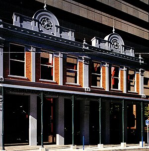
Kimberley House
Building in Johannesburg, South Africa
Distance: Approx. 271 meters
Latitude and longitude: -26.20432,28.04227
The Kimberley house at 44 Pritchard street is Victorian style and one of the oldest buildings in the city of Johannesburg. The building was constructed in 1892 by the architect Chris J Olley and the owners of the building ran a shop for various kinds of fashion wares. With limited resources at their disposal, the builders used oxen to fetch material ordered from England to Johannesburg.
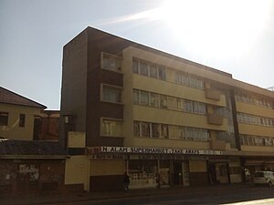
Dorkay House
Building in Johannesburg, South Africa
Distance: Approx. 271 meters
Latitude and longitude: -26.20431,28.04225
Dorkay House is situated on Portion 168 of Farm Turnfontein at 5–7 Eloff Street, Johannesburg, South Africa. It was constructed in 1952 and was designed by architect Colman Segal (1923–1988). It takes its name from the original owner, Dora Kotzen.
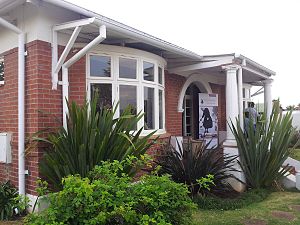
Dr Xuma house
House in Sophiatown, South Africa
Distance: Approx. 271 meters
Latitude and longitude: -26.20431,28.04225
Dr. Xuma's house was one of two houses to escape the destruction of Sophiatown, South Africa by the government in the late 1950s, it is also a landmark which belonged to Dr Alfred Bitini Xuma who was a medical doctor and the President of the African National Congress (ANC) and Chairperson of the Western Areas Anti-Expropriation and Proper Housing Committee. Construction of the house was completed in 1935 and named Empilweni which roughly translates to "the place of life".
Circle Court, Johannesburg
Residence apartments in Hillbrow, Johannesburg South Africa
Distance: Approx. 292 meters
Latitude and longitude: -26.20452,28.04224
Circle Court is a residential building in Johannesburg, Hillbrow was designed by the company of brothers Luis Theodore Obel and Mark Obel in 1936. They both favoured the Art Deco style of design. During the time when the building was constructed, Clarendon circle was a famous landmark with a large traffic circle surrounding an island of grass and palm trees, this was replaced by traffic lights in 1959.
President Street Synagogue
Former Jewish synagogue in Transvaal, South Africa.
Distance: Approx. 223 meters
Latitude and longitude: -26.2036,28.0452
The President Street Synagogue was a former Jewish congregation and synagogue, located in Johannesburg, Transvaal, South Africa. It was the first synagogue in Transvaal and was completed in 1889. The synagogue building was sold in 1926.
Weather in this IP's area
broken clouds
26 Celsius
26 Celsius
24 Celsius
27 Celsius
1012 hPa
59 %
1012 hPa
830 hPa
10000 meters
1.79 m/s
4.47 m/s
122 degree
78 %