Country:
Region:
City:
Latitude and Longitude:
Time Zone:
Postal Code:
IP information under different IP Channel
ip-api
Country
Region
City
ASN
Time Zone
ISP
Blacklist
Proxy
Latitude
Longitude
Postal
Route
Luminati
Country
ASN
Time Zone
America/Chicago
ISP
ISS-GOVERNANCE
Latitude
Longitude
Postal
IPinfo
Country
Region
City
ASN
Time Zone
ISP
Blacklist
Proxy
Latitude
Longitude
Postal
Route
db-ip
Country
Region
City
ASN
Time Zone
ISP
Blacklist
Proxy
Latitude
Longitude
Postal
Route
ipdata
Country
Region
City
ASN
Time Zone
ISP
Blacklist
Proxy
Latitude
Longitude
Postal
Route
Popular places and events near this IP address

Montgomery College
Public college in Montgomery County, Maryland, US
Distance: Approx. 2175 meters
Latitude and longitude: 39.0982,-77.1591
Montgomery College (MC) is a public community college in Montgomery County, Maryland. The school was founded in 1946 as Montgomery Junior College. Four years later, it absorbed the 57-year-old Bliss Electrical School, which became the junior college's electrical program.

Shady Grove station
Washington Metro station
Distance: Approx. 1502 meters
Latitude and longitude: 39.12,-77.16472222
Shady Grove station is a Washington Metro station in Redland, Maryland, United States. The station opened on December 15, 1984 as part of a four-stop extension of the Red Line from Grosvenor–Strathmore station to Shady Grove. The station is operated by the Washington Metropolitan Area Transit Authority (WMATA).

Montgomery County Public Schools (Maryland)
Public school district in Maryland, US
Distance: Approx. 2535 meters
Latitude and longitude: 39.09484,-77.15749
Montgomery County Public Schools (MCPS) is a public school district that serves Montgomery County, Maryland. With 210 schools, it is the largest school district in the state of Maryland. For the 2022–23 school year, the district had about 160,554 students taught by about 13,994 teachers, 86.4 percent of whom had a master's degree or equivalent.
BAE Systems Inc.
American defense contractor
Distance: Approx. 1835 meters
Latitude and longitude: 39.09472222,-77.17861111
BAE Systems Inc. (formerly BAE Systems North America) is an American subsidiary of multinational defense, security, and aerospace company BAE Systems plc. The American subsidiary operates under a Special Security Agreement which allows it to work on some of the most sensitive United States defense programs despite its foreign ownership.
WLXE
Radio station in Rockville, Maryland, serving Washington, D.C.
Distance: Approx. 2789 meters
Latitude and longitude: 39.09722222,-77.15111111
WLXE is a radio station broadcasting on 1600 kHz in the medium wave AM band. Its studios and transmitters are located in Rockville, Maryland, and it serves the Washington metropolitan area. WLXE broadcasts music programming in the Spanish language.

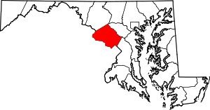
Derwood, Maryland
Census-designated place in Maryland, United States
Distance: Approx. 2353 meters
Latitude and longitude: 39.11361111,-77.15083333
Derwood is an unincorporated area and census-designated place in east-central Montgomery County, Maryland, United States. It lies just north of Rockville, southeast of Gaithersburg, southwest of Olney, and northwest of the greater Silver Spring area. Derwood was originally "Deer Park" and was then "Deer Wood" before getting its current name.

Adventist HealthCare Shady Grove Medical Center
Hospital in Maryland USA, founded 1979
Distance: Approx. 2292 meters
Latitude and longitude: 39.09861111,-77.19888889
Adventist HealthCare Shady Grove Medical Center is a 266-licensed bed acute care facility located in Rockville, Maryland. Shady Grove Medical Center provides a range of health services to the community such as high-risk obstetrical care, cardiac and vascular care, oncology services, orthopedic care, surgical services and pediatric care. Opened in 1979 as Shady Grove Adventist Hospital, Shady Grove Medical Center operates as part of Adventist HealthCare, a health-care delivery system that includes hospitals, home health agencies and other health-care services.

Shady Grove, Maryland
Unincorporated area in Maryland
Distance: Approx. 949 meters
Latitude and longitude: 39.1183,-77.18398333
Shady Grove is an unincorporated area of Montgomery County, Maryland, United States. It has a population of 5,000-7,000, between the cities of Rockville and Gaithersburg, mostly in zip codes 20850 and 20855, though the exact boundaries are not officially defined.

Washington Grove station
MARC rail station in Washington Grove, Maryland, United States
Distance: Approx. 2804 meters
Latitude and longitude: 39.13638889,-77.17763889
Washington Grove is a passenger rail station in Washington Grove, Maryland, on MARC Train's Brunswick Line. The station serves a historic community near Washington, D.C. that was a summer retreat for many of its citizens during the nineteenth and twentieth centuries, but that recently have become year-round residences without destroying the outward appearance of the original structures in the community. Originally the rail connection provided the transportation to the community, which is designed only for pedestrian use along footpaths.

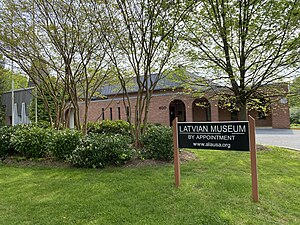
Latvian Museum
Museum in Maryland, USA
Distance: Approx. 2766 meters
Latitude and longitude: 39.08637,-77.179127
The Latvian Museum in Rockville, Maryland has as its mission the preservation and communication of Latvian history and culture and the history of Latvians in the United States. The Museum is housed in facilities that include the national headquarters of the American Latvian Association as well as the Latvian Evangelical Lutheran church and Latvian Saturday school which serve the Latvian American community in the greater Washington D.C. area.
George Washington Carver High School (Rockville, Maryland)
Segregated public school in Rockville, Maryland
Distance: Approx. 2511 meters
Latitude and longitude: 39.0949,-77.1578
George Washington Carver High School and Junior College was the high school for black students in Rockville, Maryland prior to the integration of public schools, which occurred between 1955 and 1961. It replaced two earlier all-black high schools, the first founded in 1927. From that time until integration, there was only one high school for blacks in all of Montgomery County, Maryland.
RIO Washingtonian Center
Retail center in Gaithersburg, Maryland, US
Distance: Approx. 2015 meters
Latitude and longitude: 39.11723,-77.1999
RIO Washingtonian Center, stylized as rio, is a 760,000 sq ft (71,000 m2) hybrid power center and lifestyle center with shopping, restaurants, and entertainment in Gaithersburg, Maryland located immediately south of the interchange between Interstate 270 and 370. The original RIO building opened in 1982, while the adjacent "Washingtonian Center" and "Washingtonian Waterfront" were developed in 1997 and 2004. It underwent a $30 million renovation in 2020.
Weather in this IP's area
clear sky
15 Celsius
13 Celsius
13 Celsius
16 Celsius
1016 hPa
54 %
1016 hPa
998 hPa
10000 meters
4.02 m/s
7.6 m/s
34 degree
06:53:39
16:53:47