192.52.49.56 - IP Lookup: Free IP Address Lookup, Postal Code Lookup, IP Location Lookup, IP ASN, Public IP
Country:
Region:
City:
Location:
Time Zone:
Postal Code:
IP information under different IP Channel
ip-api
Country
Region
City
ASN
Time Zone
ISP
Blacklist
Proxy
Latitude
Longitude
Postal
Route
Luminati
Country
ASN
Time Zone
Europe/Berlin
ISP
Universitaet Stuttgart
Latitude
Longitude
Postal
IPinfo
Country
Region
City
ASN
Time Zone
ISP
Blacklist
Proxy
Latitude
Longitude
Postal
Route
IP2Location
192.52.49.56Country
Region
baden-wurttemberg
City
freiburg
Time Zone
Europe/Berlin
ISP
Language
User-Agent
Latitude
Longitude
Postal
db-ip
Country
Region
City
ASN
Time Zone
ISP
Blacklist
Proxy
Latitude
Longitude
Postal
Route
ipdata
Country
Region
City
ASN
Time Zone
ISP
Blacklist
Proxy
Latitude
Longitude
Postal
Route
Popular places and events near this IP address

Freiburg im Breisgau
City in Baden-Württemberg, Germany
Distance: Approx. 192 meters
Latitude and longitude: 47.995,7.85
Freiburg im Breisgau (German: [ˈfʁaɪbʊʁk ʔɪm ˈbʁaɪsɡaʊ] ; Alemannic: Friburg im Brisgau; French: Fribourg-en-Brisgau; lit. Freecastle in the Breisgau; mostly called simply Freiburg) is the fourth-largest city of the German state of Baden-Württemberg after Stuttgart, Mannheim and Karlsruhe. Its built-up area has a population of about 355,000 (2021), while the greater Freiburg metropolitan area ("Einzugsgebiet") has about 660,000 (2018).
Freiburg Minster
Church in Freiburg im Breisgau, Germany
Distance: Approx. 74 meters
Latitude and longitude: 47.99555556,7.85305556
Freiburg Minster (German: Freiburger Münster or Münster Unserer Lieben Frau) is the cathedral of Freiburg im Breisgau, southwest Germany. The last duke of Zähringen had started the building around 1200 in romanesque style. The construction continued in 1230 in Gothic style.
29th Division (German Empire)
Military unit
Distance: Approx. 219 meters
Latitude and longitude: 47.99777778,7.85305556
The 29th Division (29. Division) was a unit of the Prussian/German Army, almost entirely made up of troops from the Grand Duchy of Baden. It was formed in Karlsruhe on 1 July 1871.
Trams in Freiburg im Breisgau
German network of tramways
Distance: Approx. 210 meters
Latitude and longitude: 47.995,7.84972222
The Freiburg im Breisgau tramway network (also known as Stadtbahn or formerly as Hoobl (Alemannic for Hobel)) is a network of tramways that forms part of the public transport system in Freiburg im Breisgau, a city in the federal state of Baden-Württemberg, Germany. Established in 1901, the network has been operated since its foundation by the company now known as Freiburger Verkehrs (VAG Freiburg or VAG), and powered by electricity. The tramway network currently has five lines.
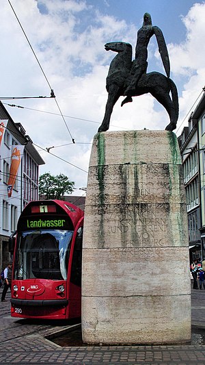
Bertoldsbrunnen
Distance: Approx. 204 meters
Latitude and longitude: 47.9949,7.8499
The Bertoldsbrunnen ("Bertold's Fountain") is a monument in the historic city of Freiburg im Breisgau. It is situated at the crossing of the Salz- and Bertoldsstraße with the Kaiser-Joseph-Straße. The fountain is one of the central locations of the city.

Minster Square (Freiburg im Breisgau)
Distance: Approx. 37 meters
Latitude and longitude: 47.9956,7.8524
The Minster Square in the centre district of Freiburg, Germany, is a paved area surrounding the Freiburger Minster. The city library, the Historical Merchants' Hall, the Wentzinger House and the Korn House are on this square. The Freiburger streams run along the sides of the square.
Augustinian Monastery, Freiburg
German monastery
Distance: Approx. 224 meters
Latitude and longitude: 47.9939,7.8525
The Augustinian Monastery of Freiburg is a former Augustinian monastery located in the Salzstraße, in the historic center of Freiburg im Breisgau. From 1278 to 1783, Augustinian monks lived in the buildings. It has a preserved Gothic cloister, and has housed the local art museum "Augustinermuseum" since 1923.
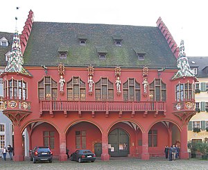
Historical Merchants' Hall (Freiburg)
Distance: Approx. 111 meters
Latitude and longitude: 47.994964,7.852727
The Historical Merchants' Hall (German: Historisches Kaufhaus) is one of the most outstanding buildings in Freiburg im Breisgau. It is situated on the south side of the Minster Square (market square around the Freiburg Minster). It stands out clearly due to its dominant red facade.
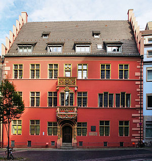
The Whale House
Distance: Approx. 129 meters
Latitude and longitude: 47.99641,7.85065
The Whale House (Haus zum Walfisch) is a late Gothic bourgeois house in the old town of Freiburg im Breisgau, Baden-Württemberg, Germany and is under conservation. The building is currently used by the Sparkasse Freiburg-Nördlicher Breisgau bank. It is part of a complex which, in the past, was made up of 17 separate buildings.
Salzstraße (Salt Road in Freiburg im Breisgau)
Distance: Approx. 181 meters
Latitude and longitude: 47.9943,7.8518
The Salzstraße (Salt Road) in Freiburg im Breisgau is a significant part of the Freiburg city centre pedestrian area. It runs from Bertoldsbrunnen to Kaiser-Joseph-Straße, then eastward to Oberlinden square, where a fountain of the same name is located. It is probably the location of Freiburg's oldest houses.
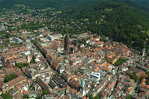
Old City of Freiburg
Stadtteil of Freiburg im Breisgau in Baden-Württemberg, Germany
Distance: Approx. 210 meters
Latitude and longitude: 47.99472222,7.85
The Old City of Freiburg is part of the city and business centres of Freiburg im Breisgau and is the core of the original city. It is divided into the two districts 111 Altstadt-Mitte and 112 Altstadt-Ring. The Altstadt-Mitte district was the city's build-up area at the time of its foundation and therefore formed the old city.
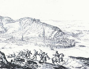
Siege of Freiburg (1677)
1677 siege
Distance: Approx. 212 meters
Latitude and longitude: 47.99638889,7.84944444
The siege of Freiburg took place between 9 and 16 November 1677, as part of the Franco-Dutch War, and ended with the conquest of the city by the French.
Weather in this IP's area
clear sky
2 Celsius
2 Celsius
0 Celsius
3 Celsius
1033 hPa
86 %
1033 hPa
997 hPa
10000 meters
0.32 m/s
0.49 m/s
12 degree
5 %


