192.51.151.15 - IP Lookup: Free IP Address Lookup, Postal Code Lookup, IP Location Lookup, IP ASN, Public IP
Country:
Region:
City:
Location:
Time Zone:
Postal Code:
IP information under different IP Channel
ip-api
Country
Region
City
ASN
Time Zone
ISP
Blacklist
Proxy
Latitude
Longitude
Postal
Route
Luminati
Country
ASN
Time Zone
Asia/Tokyo
ISP
OPTAGE Inc.
Latitude
Longitude
Postal
IPinfo
Country
Region
City
ASN
Time Zone
ISP
Blacklist
Proxy
Latitude
Longitude
Postal
Route
IP2Location
192.51.151.15Country
Region
fukuoka
City
kanda
Time Zone
Asia/Tokyo
ISP
Language
User-Agent
Latitude
Longitude
Postal
db-ip
Country
Region
City
ASN
Time Zone
ISP
Blacklist
Proxy
Latitude
Longitude
Postal
Route
ipdata
Country
Region
City
ASN
Time Zone
ISP
Blacklist
Proxy
Latitude
Longitude
Postal
Route
Popular places and events near this IP address
Yukuhashi, Fukuoka
City in Kyushu, Japan
Distance: Approx. 6024 meters
Latitude and longitude: 33.72888889,130.98305556
Yukuhashi (行橋市, Yukuhashi-shi) is a city located in Fukuoka Prefecture, Japan. As of 30 April 2024, its estimated population is 72,376, and its population density is 1000 persons per km2. The total area of the city is 70.06 km2 (27.05 sq mi).

Kanda, Fukuoka
Town in Kyushu, Japan
Distance: Approx. 829 meters
Latitude and longitude: 33.77583333,130.98055556
Kanda (苅田町, Kanda-machi) is a town located in Miyako District, Fukuoka Prefecture, Japan. As of 30 April 2024, the town had an estimated population of 37,626 in 18,877 households, and a population density of 770 persons per km2. The total area of the town is 48.98 km2 (18.91 sq mi).

Kokura Airport
Former airport of Kitakyushu, Japan
Distance: Approx. 6815 meters
Latitude and longitude: 33.83638889,130.94694444
Kokura Airport (小倉空港, Kokura Kūkō), previously called Kitakyūshū Airport (北九州空港, Kitakyūshū Kūkō) until 2005, was a small airport in Kokura Minami-ku, Kitakyūshū, Japan. There used to be four flights to and from Tokyo Haneda every day. The runway was 1,600 m (5,249 ft) long, so only mid-sized aircraft such as the Airbus A320 and Boeing 737 could use this airport, albeit with a reduced payload.
Nishinippon Institute of Technology
Distance: Approx. 3385 meters
Latitude and longitude: 33.7537,130.9732
Nishinippon Institute of Technology (西日本工業大学, Nishinihon kogyo daigaku) is a private university in the town of Kanda, Fukuoka, Japan with campus locations in Kanda and also in city of Kokurakita-ku, Kitakyūshū. It was established in 1967.

Yukuhashi Station
Railway station in Yukuhashi, Fukuoka Prefecture, Japan
Distance: Approx. 6168 meters
Latitude and longitude: 33.72861111,130.97027778
Yukuhashi Station (行橋駅, Yukuhashi-eki) is a passenger railway station located in the city of Yukuhashi, Fukuoka Prefecture, Japan. It is operated by JR Kyushu and the third-sector railway operator Heisei Chikuhō Railway..

Shimosone Station
Railway station in Kitakyushu, Japan
Distance: Approx. 7093 meters
Latitude and longitude: 33.8325,130.93472222
Shimosone Station (下曽根駅, Shimosone-eki) is a passenger railway station located in Kokuraminami-ku, Kitakyushu, Fukuoka Prefecture, Japan. It is operated by JR Kyushu.

Kusami Station
Railway station in Kitakyushu, Japan
Distance: Approx. 3739 meters
Latitude and longitude: 33.80722222,130.955
Kusami Station (朽網駅, Kusami-eki) is a passenger railway station located in Kokuraminami-ku, Kitakyushu, Fukuoka Prefecture, Japan. It is operated by JR Kyushu. It is the closest station for New Kitakyushu Airport.

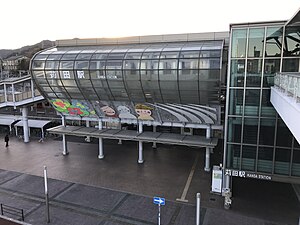
Kanda Station (Fukuoka)
Railway station in Kanda, Fukuoka Prefecture, Japan
Distance: Approx. 426 meters
Latitude and longitude: 33.78472222,130.97888889
Kanda Station (苅田駅, Kanda-eki) is a passenger railway station located in the town of Kanda, Fukuoka Prefecture, Japan. It is operated by JR Kyushu.

Obase-Nishikōdai-mae Station
Railway station in Kanda, Fukuoka Prefecture, Japan
Distance: Approx. 3487 meters
Latitude and longitude: 33.75305556,130.97194444
Obase-Nishikōdai-mae Station (小波瀬西工大前駅, Obase-Nishikōdai-mae-eki) is a passenger railway station located in the town of Kanda, Fukuoka Prefecture, Japan. It is operated by JR Kyushu.
Yamaguchi Dam (Fukuoka, Japan)
Dam in Fukuoka Prefecture, Japan
Distance: Approx. 4467 meters
Latitude and longitude: 33.76388889,130.94055556
Yamaguchi Dam is an earthfill dam located in Fukuoka Prefecture in Japan. The dam is used for irrigation and water supply. The catchment area of the dam is 3.7 km2.
Goshoyama Kofun
Distance: Approx. 2734 meters
Latitude and longitude: 33.75851111,130.98074444
The Goshoyama Kofun (御所山古墳) is a Kofun period burial mound, located in the Yohara neighborhood of the town of Kanda, Miyako District, Fukuoka Prefecture Japan. The tumulus was designated a National Historic Site of Japan in 1936, with the area under protection expanded in 2012, 2020 and 2022. Along with the Ishizukayama Kofun (also located in Kanda) it is one of the largest burial mounds in the Buzen region, and is estimated to have been constructed in the mid-late Kofun period..
Ishizukayama Kofun
Distance: Approx. 892 meters
Latitude and longitude: 33.77538889,130.98
The Ishiyamazuka Kofun (石塚山古墳) is a Kofun period burial mound, located in the Tamiku neighborhood of the town of Kanda, Miyako District, Fukuoka Prefecture Japan. The tumulus was designated a National Historic Site of Japan in 1985. Along with the Goshoyama Kofun (also located in Kanda) it is one of the oldest and largest burial mounds in the Buzen region, and is estimated to have been constructed in the early Kofun period..
Weather in this IP's area
broken clouds
5 Celsius
0 Celsius
5 Celsius
5 Celsius
1022 hPa
45 %
1022 hPa
1017 hPa
10000 meters
8.23 m/s
13.89 m/s
280 degree
75 %

