Country:
 USA
USARegion:
City:
Latitude and Longitude:
Time Zone:
Postal Code:
IP information under different IP Channel
ip-api
Country
Region
City
ASN
Time Zone
ISP
Blacklist
Proxy
Latitude
Longitude
Postal
Route
IPinfo
Country
Region
City
ASN
Time Zone
ISP
Blacklist
Proxy
Latitude
Longitude
Postal
Route
MaxMind
Country
Region
City
ASN
Time Zone
ISP
Blacklist
Proxy
Latitude
Longitude
Postal
Route
Luminati
Country
USRegion
ut
City
herriman
ASN
Time Zone
America/Denver
ISP
DATABANK-DFW
Latitude
Longitude
Postal
db-ip
Country
Region
City
ASN
Time Zone
ISP
Blacklist
Proxy
Latitude
Longitude
Postal
Route
ipdata
Country
Region
City
ASN
Time Zone
ISP
Blacklist
Proxy
Latitude
Longitude
Postal
Route
Popular places and events near this IP address

Herriman, Utah
City in Utah, United States
Distance: Approx. 963 meters
Latitude and longitude: 40.50666667,-112.03083333
Herriman ( HERR-ih-mən) is a city in southwestern Salt Lake County, Utah. The population was 55,144 as of the 2020 census. Although Herriman was a town in 2000, it has since been classified as a third-class city by state law.

Kennecott Utah Copper
Major copper mining and refining company
Distance: Approx. 4283 meters
Latitude and longitude: 40.5473,-112.0035
Kennecott Utah Copper LLC (KUC), a division of Rio Tinto Group, is a mining, smelting, and refining company. Its corporate headquarters are located in South Jordan, Utah. Kennecott operates the Bingham Canyon Mine, one of the largest open-pit copper mines in the world in Bingham Canyon, Salt Lake County, Utah.

Daybreak (community)
Planned community near Salt Lake City, Utah, United States
Distance: Approx. 4431 meters
Latitude and longitude: 40.546842,-111.99965
Daybreak is a master-planned community of over 4,000 acres (16 km²) located in South Jordan, Utah. Daybreak was originally owned by Kennecott Land but as of 2024 was being developed by the Larry H. Miller Company.

Oquirrh Mountain Utah Temple
Latter-day Saints temple in South Jordan, Utah, United States
Distance: Approx. 5462 meters
Latitude and longitude: 40.551145,-111.98751
The Oquirrh Mountain Utah Temple is a temple of the Church of Jesus Christ of Latter-day Saints located in South Jordan, Utah, a suburb of Salt Lake City. South Jordan was the first city in the world to have two temples (it also has the Jordan River Temple). The temple was the fourth in the Salt Lake Valley and the 13th in the state of Utah.
Providence Hall Charter School
Public charter school in Herriman, Utah, United States
Distance: Approx. 4056 meters
Latitude and longitude: 40.48527778,-112.00444444
Providence Hall is a K-12 charter school located in Herriman, Utah. Providence Hall was originally planned to be location in neighboring city Bluffdale, but relocated to Herriman in late 2007. It is entirely certified to be an International Baccalaureate school, with all programs from Primary Years Program (PYP), Middle Years Program (MYP), and Diploma Program (DP).
Lark, Utah
Ghost town in Utah, United States
Distance: Approx. 5588 meters
Latitude and longitude: 40.525,-112.09638889
Lark is a ghost town located 4 miles (6.4 km) west of Herriman in the Oquirrh Mountains of southwest Salt Lake County, Utah, United States. Lark was the location of several copper mines.
Paradigm High School
Charter school in the United States
Distance: Approx. 5521 meters
Latitude and longitude: 40.541,-111.9758
Paradigm High School is a charter high school in South Jordan, Utah, United States.
Herriman High School
Public school in Herriman, Utah, United States
Distance: Approx. 2069 meters
Latitude and longitude: 40.53388889,-112.03138889
Herriman High School (HHS) is a public high school in Herriman, Utah, United States. It is a part of the Jordan School District and serves students from the cities of Herriman, South Jordan, and Riverton. The school is a two-level facility, situated on a 50-acre campus, with views of the Salt Lake Valley and mountain ranges to the east and west.

South Jordan Parkway station
Distance: Approx. 4855 meters
Latitude and longitude: 40.558588,-112.024603
South Jordan Parkway station is a light rail station in the Daybreak community in South Jordan, Utah, United States, served by the Red Line of the Utah Transit Authority's (UTA) TRAX light rail system. The Red Line provides service from the University of Utah to the Daybreak community.
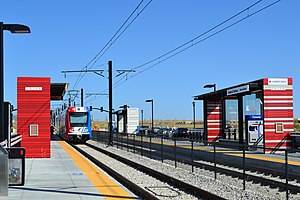
Daybreak Parkway station
Distance: Approx. 3525 meters
Latitude and longitude: 40.544027,-112.014086
Daybreak Parkway station is a light rail station in the Daybreak community of South Jordan, Utah, United States, served by the Red Line of the Utah Transit Authority's (UTA) TRAX light rail system. The station is the southwestern terminus of the Red Line, which provides service from this station to the University of Utah.
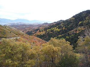
Butterfield Canyon (Utah)
Canyon in the Oquirrh Mountains, Utah, United States
Distance: Approx. 3752 meters
Latitude and longitude: 40.51305556,-112.07583333
Butterfield Canyon is a canyon in the Oquirrh Mountains in southwest Salt Lake County, Utah, United States located just west of the city of Herriman. Locals use this canyon to commute to and from Herriman/Tooele. Butterfield Canyon Road is a recreation road.

Mountain Ridge High School (Utah)
Public secondary school in Herriman, Utah, United States
Distance: Approx. 3666 meters
Latitude and longitude: 40.4948,-111.9977
Mountain Ridge High School is a public high school in Herriman, Utah. It serves students in grades 10-12 for the Jordan School District.
Weather in this IP's area
clear sky
19 Celsius
18 Celsius
18 Celsius
21 Celsius
1013 hPa
36 %
1013 hPa
853 hPa
10000 meters
1.54 m/s
150 degree
07:02:48
19:48:46