Country:
 USA
USARegion:
City:
Latitude and Longitude:
Time Zone:
Postal Code:
IP information under different IP Channel
ip-api
Country
Region
City
ASN
Time Zone
ISP
Blacklist
Proxy
Latitude
Longitude
Postal
Route
IPinfo
Country
Region
City
ASN
Time Zone
ISP
Blacklist
Proxy
Latitude
Longitude
Postal
Route
MaxMind
Country
Region
City
ASN
Time Zone
ISP
Blacklist
Proxy
Latitude
Longitude
Postal
Route
Luminati
Country
USASN
Time Zone
America/Chicago
ISP
DATABANK-DFW
Latitude
Longitude
Postal
db-ip
Country
Region
City
ASN
Time Zone
ISP
Blacklist
Proxy
Latitude
Longitude
Postal
Route
ipdata
Country
Region
City
ASN
Time Zone
ISP
Blacklist
Proxy
Latitude
Longitude
Postal
Route
Popular places and events near this IP address

Bluffdale, Utah
City in Utah, United States
Distance: Approx. 3527 meters
Latitude and longitude: 40.47333333,-111.94444444
Bluffdale is a city in Salt Lake and Utah counties in the U.S. state of Utah, located about 20 miles (32 km) south of Salt Lake City. As of the 2020 census, the city population was 17,014.

Draper, Utah
City in Utah, United States
Distance: Approx. 4587 meters
Latitude and longitude: 40.51472222,-111.87305556
Draper is a city in Salt Lake and Utah counties in the U.S. state of Utah, about 20 miles (32 km) south of Salt Lake City along the Wasatch Front. As of the 2020 census, the population is 51,017, up from 7,143 in 1990. Draper is part of two metropolitan areas; the Salt Lake County portion is in the Salt Lake City metropolitan area, while the Utah County portion is in the Provo-Orem metropolitan area.

Traverse Mountains
Mountain range separating the Salt Lake Valley and Utah Valley
Distance: Approx. 2042 meters
Latitude and longitude: 40.47189,-111.88299
The Traverse Mountains, or sometimes Traverse Range, are an anomalous, geologically complex, east-trending range that separates Salt Lake Valley and Utah Valley in Salt Lake and Utah counties in the U.S. State of Utah. Point of the Mountain is colloquially used to refer to the part of this range that separates the Salt Lake City and Provo metropolitan areas, as well as the mountain pass at 40°27′13″N 111°54′38″W, used by the highways and rail arteries that connect the two areas.

Utah State Prison
Former mixed security prison in Draper, Utah, United States
Distance: Approx. 1245 meters
Latitude and longitude: 40.49166667,-111.9
Utah State Prison (USP) was one of two prisons managed by the Utah Department of Corrections' Division of Institutional Operations. It was located in Draper, Utah, United States, about 20 miles (32 km) southwest of Salt Lake City. It was replaced by the Utah State Correctional Facility in July 2022.
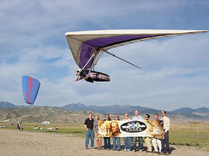
Flight Park State Recreation Area
State park in Utah, United States
Distance: Approx. 2586 meters
Latitude and longitude: 40.45777778,-111.90111111
Flight Park State Recreation Area is a state park in northern Utah, United States, dedicated to hang gliding and paragliding.
Utah and Salt Lake Canal
Canal in Salt Lake County, Utah, United States
Distance: Approx. 4511 meters
Latitude and longitude: 40.44305556,-111.92305556
The Utah and Salt Lake Canal is an historic waterway in Salt Lake County, Utah, United States.
South Jordan Canal
Distance: Approx. 3336 meters
Latitude and longitude: 40.46015,-111.932425
The South Jordan Canal is an historic waterway in Salt Lake County, Utah, United States.

Draper station (FrontRunner)
Commuter rail station in Draper, Utah, US
Distance: Approx. 3827 meters
Latitude and longitude: 40.51527778,-111.90444444
Draper station is a FrontRunner commuter rail station in Draper, Utah. It is operated by the Utah Transit Authority (UTA) and is part of the FrontRunner South extension.

J. R. Allen House
Historic house in Utah, United States
Distance: Approx. 5017 meters
Latitude and longitude: 40.51222222,-111.86138889
The J. R. Allen House, is a historic house located at 1047 East 13200 South in Draper, Utah. It is significant as one of relatively few surviving residences designed by Richard K.A. Kletting.

Draper–Steadman House
Historic house in Utah, United States
Distance: Approx. 3976 meters
Latitude and longitude: 40.50527778,-111.93833333
The Draper–Steadman House (also known as the Draper–Steadman–Morgan House) is a historic house located at 13518 South 1700 West in Riverton, Utah, United States.

Corner Canyon High School
School in Draper, Utah, United States
Distance: Approx. 4928 meters
Latitude and longitude: 40.517,-111.8703
Corner Canyon High School is a public school in Draper, Utah. It is the newest high school in the Canyons School District. Its colors are navy, silver and white, and its mascot is the Chargers.
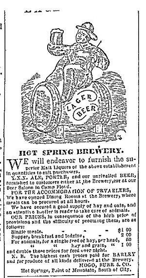
Hot Springs Hotel and Brewery
Distance: Approx. 1819 meters
Latitude and longitude: 40.47,-111.92
Hot Springs Hotel and Brewery was a Utah Pony Express station, inn and brewery founded in 1856 by Porter Rockwell at Point of the Mountain, modern-day Bluffdale, Utah. It was a contract Pony Express station, ten miles south of Trader's Rest station. Rockwell is known historically as the bodyguard of early Mormon leader and Utah settler Brigham Young.
Weather in this IP's area
clear sky
26 Celsius
25 Celsius
24 Celsius
27 Celsius
1002 hPa
24 %
1002 hPa
856 hPa
10000 meters
8.23 m/s
14.4 m/s
180 degree
07:09:56
19:34:47