192.40.38.27 - IP Lookup: Free IP Address Lookup, Postal Code Lookup, IP Location Lookup, IP ASN, Public IP
Country:
Region:
City:
Location:
Time Zone:
Postal Code:
IP information under different IP Channel
ip-api
Country
Region
City
ASN
Time Zone
ISP
Blacklist
Proxy
Latitude
Longitude
Postal
Route
Luminati
Country
ASN
Time Zone
America/Toronto
ISP
CASALE-MEDIA
Latitude
Longitude
Postal
IPinfo
Country
Region
City
ASN
Time Zone
ISP
Blacklist
Proxy
Latitude
Longitude
Postal
Route
IP2Location
192.40.38.27Country
Region
ontario
City
toronto
Time Zone
America/Toronto
ISP
Language
User-Agent
Latitude
Longitude
Postal
db-ip
Country
Region
City
ASN
Time Zone
ISP
Blacklist
Proxy
Latitude
Longitude
Postal
Route
ipdata
Country
Region
City
ASN
Time Zone
ISP
Blacklist
Proxy
Latitude
Longitude
Postal
Route
Popular places and events near this IP address

Glencairn station
Toronto subway station
Distance: Approx. 1380 meters
Latitude and longitude: 43.70888889,-79.44083333
Glencairn is a subway station on Line 1 Yonge–University in Toronto, Ontario, Canada. It is located in the median of William R. Allen Road at Glencairn Avenue. Wi-Fi service is available at this station.
Barker Field
Former airfield in Toronto
Distance: Approx. 1325 meters
Latitude and longitude: 43.715,-79.45611111
Barker Field was one of several airfields in the Yorkdale area of Toronto, Ontario, Canada.
CIBC 750 Lawrence
Office complex in Toronto, Ontario, Canada
Distance: Approx. 1487 meters
Latitude and longitude: 43.715691,-79.449837
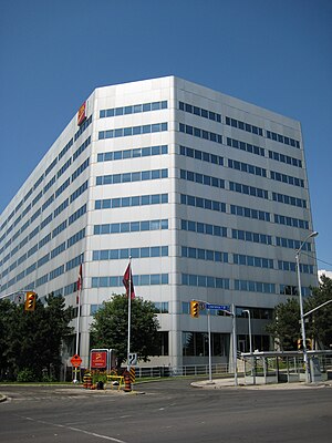
CIBC 750 Lawrence is a two-tower office complex in Toronto, Ontario, Canada. It opened in 1981 as a branch and a sub-unit of Canadian Imperial Bank of Commerce's (CIBC) head office branch at Commerce Court, and is the main headquarters of CIBC Credit Card Services, including Visa call centres and Visa operations. It is located in Lawrence Heights across the street from Lawrence Square Shopping Centre and a short walk to Lawrence West subway station.

Fairbank Memorial Park
Distance: Approx. 1462 meters
Latitude and longitude: 43.691576,-79.447299
Fairbank Memorial Park is a park located in the neighbourhood of Fairbank in Toronto, Ontario, Canada.

Yorkdale–Glen Park
Neighbourhood in Toronto, Ontario, Canada
Distance: Approx. 844 meters
Latitude and longitude: 43.708,-79.448
Yorkdale–Glen Park is a neighbourhood in the city of Toronto, Ontario, Canada, located in the former suburb of North York. It is bounded by Highway 401 to the north, Allen Road to the east, a line south of Stayner Avenue to the south, and the CNR tracks to the west.

Fairbank, Toronto
Neighbourhood in Toronto, Ontario, Canada
Distance: Approx. 969 meters
Latitude and longitude: 43.69555556,-79.45
Fairbank is a neighbourhood in Toronto, Ontario, Canada. The area is centred on the intersection of Dufferin Street and Eglinton Avenue West. Fairbank includes the neighbourhoods of Briar Hill–Belgravia (North of Eglinton Avenue West) and Caledonia–Fairbank (South of Eglinton Avenue West).

Little Jamaica
Neighbourhood of Toronto in Ontario, Canada
Distance: Approx. 955 meters
Latitude and longitude: 43.69454,-79.4553
Little Jamaica, also known as Eglinton West, is an ethnic enclave in Toronto, Ontario, Canada. It is located along Eglinton Avenue West, from Marlee Avenue to Keele Street, and is part of four neighbourhoods: Silverthorn, Briar Hill–Belgravia, Caledonia–Fairbank, and Oakwood–Vaughan. The commercial main street has been recognized to be of great cultural heritage significance to the city of Toronto, as a distinct ethnic and cultural hub for Afro-Caribbean immigrants for many decades.

Dante Alighieri Academy
Catholic high school in Toronto, Ontario, Canada
Distance: Approx. 830 meters
Latitude and longitude: 43.7104,-79.4581
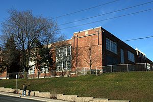
Dante Alighieri Academy (Dante Alighieri, DAA, or Dante, official name: Dante Alighieri Catholic Academy) also known as Dante Alighieri Academy Catholic Secondary School is a Catholic public high school in Toronto, Ontario, Canada. Administered by the Toronto Catholic District School Board, it serves the Glen Park neighbourhood in the North York district. It has 926 students from grades 9-12 as of 2018–19.

Caledonia station
Future LRT station in Toronto, Canada
Distance: Approx. 1434 meters
Latitude and longitude: 43.69222222,-79.46555556
Caledonia is an underground light rail transit (LRT) station under construction on Line 5 Eglinton, a new line that is part of the Toronto subway system. It will be located along Eglinton Avenue between the GO Transit Barrie rail corridor and the entrance to the Westside Mall. This is about 200 metres (660 ft) west of Caledonia Road opposite Blackthorn Avenue.

Fairbank station
Future LRT station in Toronto, Canada
Distance: Approx. 969 meters
Latitude and longitude: 43.69555556,-79.45
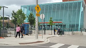
Fairbank is an underground light rail transit (LRT) station under construction on Line 5 Eglinton, a new line that is part of the Toronto subway system. It will be located in the Fairbank neighbourhood at the intersection of Dufferin Street and Eglinton Avenue West. Destinations include the Fairbank neighbourhood and Fairbank Memorial Park.

Oakwood station (Toronto)
Future underground LRT station in Toronto, Canada
Distance: Approx. 1230 meters
Latitude and longitude: 43.69722222,-79.44305556
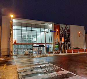
Oakwood is an underground light rail transit (LRT) station under construction on Line 5 Eglinton, a new line that is part of the Toronto subway system. It will be located in the Little Jamaica neighbourhood at the intersection of Oakwood Avenue and Eglinton Avenue. It is scheduled to open in 2024.

Lycée Français Toronto
French international school in Toronto
Distance: Approx. 1208 meters
Latitude and longitude: 43.6935,-79.449
Lycée Français Toronto (LFT) is a French international school in the Fairbank neighbourhood of Toronto. It serves levels PreK-12 and as of 2015 has 450 students. It was established in 1995.
Weather in this IP's area
light snow
-2 Celsius
-6 Celsius
-3 Celsius
-1 Celsius
1030 hPa
85 %
1030 hPa
1008 hPa
10000 meters
3.09 m/s
20 degree
100 %
