Country:
 Sweden
Region:
City:
Latitude and Longitude:
Time Zone:
Postal Code:
IP information under different IP Channel
ip-api
Country
Region
City
ASN
Time Zone
ISP
Blacklist
Proxy
Latitude
Longitude
Postal
Route
IPinfo
Country
Region
City
ASN
Time Zone
ISP
Blacklist
Proxy
Latitude
Longitude
Postal
Route
MaxMind
Country
Region
City
ASN
Time Zone
ISP
Blacklist
Proxy
Latitude
Longitude
Postal
Route
Luminati
Country
SEASN
Time Zone
Europe/Stockholm
ISP
Tele2 SWIPnet
Latitude
Longitude
Postal
db-ip
Country
Region
City
ASN
Time Zone
ISP
Blacklist
Proxy
Latitude
Longitude
Postal
Route
ipdata
Country
Region
City
ASN
Time Zone
ISP
Blacklist
Proxy
Latitude
Longitude
Postal
Route
Popular places and events near this IP address

Karlskrona
Place in Blekinge, Sweden
Distance: Approx. 64 meters
Latitude and longitude: 56.16083333,15.58611111
Karlskrona (UK: , US: , Swedish: [kaɭsˈkrûːna] ) is a locality and the seat of Karlskrona Municipality, Blekinge County, Sweden with a population of 66,675 in 2018. It is also the capital of Blekinge County. Karlskrona is known as Sweden's only baroque city and is host to Sweden's largest naval base and the headquarters of the Swedish Coast Guard.

Karlskrona Admiralty Church
Church in Blekinge County, Sweden
Distance: Approx. 541 meters
Latitude and longitude: 56.15694444,15.59111111
The Karlskrona Admiralty Church (Swedish: Karlskrona amiralitetskyrka) is a church in Karlskrona, Sweden. The church is also known as the Ulrica Pia in honor of Queen Ulrike Eleonora of Denmark, Queen consort of King Charles XI of Sweden ('pia' is the feminine form of the Latin 'pius' which means 'pious').

Rosenbom
Distance: Approx. 541 meters
Latitude and longitude: 56.15694444,15.59111111
In front of the Karlskrona Admiralty Church, in Sweden, the popular wooden figure of Gubben Rosenbom (Old Man Rosenbom) has been standing since the mid 18th century. In 1956 the original was replaced by a copy and put in a safer place inside the church. The life-size figure is actually a poor box, which means, if you lift its hat, you can insert a coin for the poor.

Karlskrona naval base
UNESCO World Heritage Site in Blekinge County, Sweden
Distance: Approx. 567 meters
Latitude and longitude: 56.15611111,15.58638889
The Karlskrona naval base (Swedish: Karlskrona örlogsbas) is the largest naval base of the Swedish Navy. Located in Blekinge in southern Sweden, the base has close ties with the city of Karlskrona. It has an exceptionally well-sheltered location: arcs of islands provide a strong defense not only from the sea but also from land attacks.

3rd Naval Warfare Flotilla (Sweden)
Swedish naval unit
Distance: Approx. 439 meters
Latitude and longitude: 56.157274,15.586295
The 3rd Naval Warfare Flotilla (Swedish: Tredje sjöstridsflottiljen or 3. sjöstridsflj) of the Swedish Fleet was founded in 2005 when the former minelayer and surface flotillas joined together. The flotilla home base is in Karlskrona, Blekinge and is a part of the Karlskrona naval base.
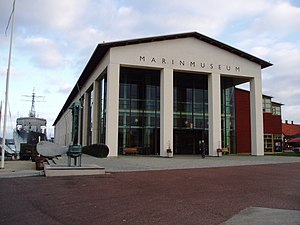
Marinmuseum
Military history museum in Sweden
Distance: Approx. 781 meters
Latitude and longitude: 56.1614,15.5995
Marinmuseum (previously: Shipyard Museum, Varvsmuseet; alternate: Naval Dockyard Museum; translation: Naval Museum) is a maritime museum located on Stumholmen island, in Karlskrona. It is Sweden's national naval museum, dedicated to the Swedish naval defense and preservation of the country's naval history.

Stumholmen
Place in Blekinge, Sweden
Distance: Approx. 687 meters
Latitude and longitude: 56.16,15.59777778
Stumholmen is a small island to the east of Trossö in Karlskrona, Sweden. It is connected to the center of Karlskrona by the Bastionsgatan bridge. Formerly the property of the Navy, today it houses the National Naval Museum (Marinmuseum), one of Sweden's oldest founded in 1752, the Hyper Island educational complex, and several other historic buildings.

Trinity Church (Karlskrona)
Distance: Approx. 98 meters
Latitude and longitude: 56.16055556,15.58583333
The Trinity Church (Swedish: Trefaldighetskyrkan, alternate, "German Church") is located at Karlskrona in Blekinge, Sweden. Along with the Fredrik Church (Fredrikskyrkan), the church is situated in the main square, (Stortorget), at the center of the island of Trossö. The church was built in Baroque architecture for the town's German-speaking population.

Fredrik Church
Church in Karlskrona, Sweden
Distance: Approx. 69 meters
Latitude and longitude: 56.16111,15.588
The Fredrik Church (Swedish: Fredrikskyrkan) is located in Karlskrona, Blekinge Län, southern Sweden. Situated on Stortorget, the main square in the city centre, The Fredrik Church is included within the Karlskrona UNESCO World Heritage Site.

Hedvig Eleonora Church (Karlskrona)
Distance: Approx. 430 meters
Latitude and longitude: 56.16375,15.59211111
The Hedvig Eleonora Church was located in Karlskrona, Blekinge County, southern Sweden. It was situated at the corner of Drottninggatan/Östra Köpmangatan. Consecrated in 1685, it was the city's first parish church, and was built as a temporary wooden church in anticipation of a stone church which the king promised that the Crown would fund.

Stortorget, Karlskrona
Largest square in Karlskrona
Distance: Approx. 6 meters
Latitude and longitude: 56.1612,15.5868
Stortorget (Swedish "Great Square") in Karlskrona is the largest square of the city. The square lies centrally on Trossö island. The square lies on the highest point of the island and is bounded by several monumental buildings.
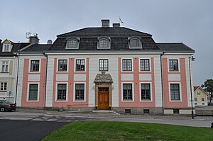
Karlskrona Residence
Distance: Approx. 493 meters
Latitude and longitude: 56.15805556,15.5925
The county residence in Karlskrona (Swedish: länsresidenset i Karlskrona) is the formal residence of the County Governor of Blekinge County, Sweden. It is located in central Karlskrona. The residence is the most recently built among the formal residences of Swedish county governors.
Weather in this IP's area
overcast clouds
12 Celsius
12 Celsius
12 Celsius
12 Celsius
1020 hPa
78 %
1020 hPa
1018 hPa
10000 meters
3.42 m/s
5.29 m/s
158 degree
93 %
07:35:47
17:49:23