192.34.55.79 - IP Lookup: Free IP Address Lookup, Postal Code Lookup, IP Location Lookup, IP ASN, Public IP
Country:
 Canada
Region:
City:
Location:
Time Zone:
Postal Code:
ISP:
ASN:
language:
User-Agent:
Proxy IP:
Blacklist:
IP information under different IP Channel
ip-api
Country
Region
City
ASN
Time Zone
ISP
Blacklist
Proxy
Latitude
Longitude
Postal
Route
db-ip
Country
Region
City
ASN
Time Zone
ISP
Blacklist
Proxy
Latitude
Longitude
Postal
Route
IPinfo
Country
Region
City
ASN
Time Zone
ISP
Blacklist
Proxy
Latitude
Longitude
Postal
Route
IP2Location
192.34.55.79Country
caRegion
ontario
City
toronto
Time Zone
America/Toronto
ISP
Language
User-Agent
Latitude
Longitude
Postal
ipdata
Country
Region
City
ASN
Time Zone
ISP
Blacklist
Proxy
Latitude
Longitude
Postal
Route
Popular places and events near this IP address

The Kingsway, Toronto
Neighbourhood in Toronto, Ontario, Canada
Distance: Approx. 286 meters
Latitude and longitude: 43.6475,-79.51138889
The Kingsway is a residential neighbourhood in Toronto, Ontario, Canada. It is bounded by Bloor Street to the south, Dundas Street to the north, the Mimico Creek to the west and the Humber River to the east. The neighbourhood was officially known as Kingsway Park, which later became replaced by its nickname the Kingsway.

Teiaiagon
Distance: Approx. 1345 meters
Latitude and longitude: 43.6560132,-79.49539641
Teiaiagon was an Iroquoian village on the east bank of the Humber River in what is now the York district of Toronto, Ontario, Canada. It was located along the Toronto Carrying-Place Trail. The site is near the current intersection of Jane Street and Annette Street, at which is situated the community of Baby Point.

Islington station (Toronto)
Toronto subway station
Distance: Approx. 1389 meters
Latitude and longitude: 43.64527778,-79.52472222
Islington is a subway station on Line 2 Bloor–Danforth of the Toronto subway in Toronto, Ontario, Canada. It is located on the north side of Bloor Street West on the west side of Islington Avenue. A central platform serves trains running in both directions.

Royal York station
Toronto subway station
Distance: Approx. 281 meters
Latitude and longitude: 43.64805556,-79.51138889
Royal York is a subway station on Line 2 Bloor–Danforth of the Toronto subway in Toronto, Ontario, Canada. It is located just north of Bloor Street West on the east side of Royal York Road.
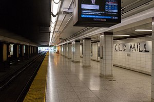
Old Mill station
Toronto subway station
Distance: Approx. 1101 meters
Latitude and longitude: 43.64972222,-79.49444444
Old Mill is a subway station on Line 2 Bloor–Danforth of the Toronto subway in Toronto, Ontario, Canada. It is located at 2672 Bloor Street West at Old Mill Terrace and Humber Boulevard in the Kingsway residential neighbourhood. Nearby destinations include the Old Mill Inn and Park Lawn Cemetery.

Etobicoke Collegiate Institute
Public high school in Toronto, Ontario, Canada
Distance: Approx. 1196 meters
Latitude and longitude: 43.65020278,-79.52242778
Etobicoke Collegiate Institute (ECI, Etobicoke CI), previously known as Etobicoke High School is a high school in Toronto, Ontario, Canada. It is located in the Islington neighbourhood of the former suburb of Etobicoke. It is overseen by the Toronto District School Board.

Étienne Brûlé Park
Park in Toronto, Ontario, Canada
Distance: Approx. 1207 meters
Latitude and longitude: 43.65277778,-79.49444444
Étienne Brûlé Park is located in the Humber River valley just north of Bloor Street West in Toronto, Ontario, Canada. It is named after Étienne Brûlé, an early French explorer in the Toronto area. It is believed that Étienne Brûlé was the first European to see Lake Ontario in 1615, from a high point of land beside the Humber.

Royal York Road
Thoroughfare in Toronto, Ontario
Distance: Approx. 952 meters
Latitude and longitude: 43.655,-79.5147
Royal York Road, historically known as Church Street or New Church Street, is a north-south arterial road in Toronto, Ontario, Canada. It is a concession road, 5 concessions (10 km) west of Yonge Street, and runs through many residential neighbourhoods, most notably Mimico and the Kingsway. It is classified as a "minor arterial" road by the city of Toronto.

Old Mill Toronto
Building in Ontario, Canada
Distance: Approx. 1215 meters
Latitude and longitude: 43.65083333,-79.49333333
The Old Mill Toronto is an event venue with a boutique hotel, spa and restaurant, in The Kingsway neighbourhood of Toronto, Ontario, Canada. It includes facilities for business meetings, conferences, celebrations and weddings, with an on-site chapel and wedding garden. Its restaurant has served afternoon tea since it opened in 1914 and serves Sunday family brunch and dinner buffets.

Park Lawn Cemetery
Canadian cemetery in Toronto
Distance: Approx. 569 meters
Latitude and longitude: 43.647094,-79.500954
Park Lawn Cemetery is a large cemetery in the Etobicoke district of Toronto, Ontario, Canada. It currently has around 22,000 graves. It is managed by the Park Lawn Limited Partnership, which also runs five other cemeteries in Toronto.

Magasin Royal
Distance: Approx. 1174 meters
Latitude and longitude: 43.655,-79.497
Magasin royal (French for 'royal store') was the generic name given to a trading post under the purview of the King of France. The name also applied specifically to two trading posts that were built during the 18th century for French fur trading near the Humber River in the Pays d'en Haut region of New France, in present-day Toronto, Ontario, Canada. According to Ron Brown, author of From Queenston to Kingston: The Hidden Heritage of Lake Ontario's Shoreline, the fort was "little more than a log cabin", and archeologists considered it "the first non-aboriginal building in the Toronto area".

Kingsway College School
Distance: Approx. 1445 meters
Latitude and longitude: 43.65702,-79.52081
Kingsway College School (KCS) is a JK to Grade 12 co-ed private independent school founded in 1989. The Junior School is located on Dundas Street West in The Kingsway area of Etobicoke and the Senior School is located on Lake Shore Boulevard West in west Toronto, Ontario, Canada.
Weather in this IP's area
mist
1 Celsius
-2 Celsius
0 Celsius
2 Celsius
1014 hPa
91 %
1014 hPa
998 hPa
2414 meters
3.09 m/s
220 degree
100 %