192.34.164.25 - IP Lookup: Free IP Address Lookup, Postal Code Lookup, IP Location Lookup, IP ASN, Public IP
Country:
Region:
City:
Location:
Time Zone:
Postal Code:
IP information under different IP Channel
ip-api
Country
Region
City
ASN
Time Zone
ISP
Blacklist
Proxy
Latitude
Longitude
Postal
Route
Luminati
Country
Region
va
City
rockymount
ASN
Time Zone
America/New_York
ISP
SHENTEL
Latitude
Longitude
Postal
IPinfo
Country
Region
City
ASN
Time Zone
ISP
Blacklist
Proxy
Latitude
Longitude
Postal
Route
IP2Location
192.34.164.25Country
Region
virginia
City
redwood
Time Zone
America/New_York
ISP
Language
User-Agent
Latitude
Longitude
Postal
db-ip
Country
Region
City
ASN
Time Zone
ISP
Blacklist
Proxy
Latitude
Longitude
Postal
Route
ipdata
Country
Region
City
ASN
Time Zone
ISP
Blacklist
Proxy
Latitude
Longitude
Postal
Route
Popular places and events near this IP address
Franklin County, Virginia
County in Virginia, United States
Distance: Approx. 9928 meters
Latitude and longitude: 36.99,-79.88
Franklin County is a county located in the Blue Ridge foothills of the Commonwealth of Virginia. As of the 2020 census, the population was 54,477. Its county seat is Rocky Mount.
Union Hall, Virginia
CDP in Virginia, United States
Distance: Approx. 7315 meters
Latitude and longitude: 37.02638889,-79.69194444
Union Hall is a census-designated place (CDP) in Franklin County, Virginia, United States. The population estimate was approximately 1,091 according to a census in 2018. It is part of the Roanoke Metropolitan Statistical Area.
Pigg River
Distance: Approx. 4259 meters
Latitude and longitude: 36.971469,-79.791253
The Pigg River is a river in south-west Virginia in the United States. It is a tributary of the Roanoke River, which flows to the Atlantic Ocean via Albemarle Sound. The Pigg River rises on Fivemile Mountain in western Franklin County and flows generally eastwardly through Franklin and Pittsylvania Counties, past the town of Rocky Mount.

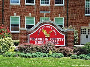
Franklin County High School (Rocky Mount, Virginia)
Public high school
Distance: Approx. 9646 meters
Latitude and longitude: 37.00422222,-79.87858333
Franklin County High School(FCHS) is located in Rocky Mount, Virginia. Approximately 1900 students attend Franklin County High School, which was founded in 1950. Since its founding, Franklin County High School, commonly known as FCHS, has grown to the largest school in the state west of Richmond.
Bald Knob (Franklin County, Virginia)
Summit in Franklin County, Virginia
Distance: Approx. 9945 meters
Latitude and longitude: 36.999,-79.88163889
Bald Knob is a summit located in Franklin County, Virginia. The summit has an elevation of 1400 feet and is a familiar landmark overlooking the county seat, Rocky Mount.
Redwood, Virginia
Unincorporated community in Virginia, United States
Distance: Approx. 4041 meters
Latitude and longitude: 37.02,-79.81194444
Redwood is an unincorporated community in Franklin County, Virginia, United States. Redwood is located on Virginia State Route 40 4.7 miles (7.6 km) east-northeast of Rocky Mount. Redwood has a post office with ZIP code 24146, which opened on August 9, 1880.
Glade Hill, Virginia
Unincorporated community in Virginia, United States
Distance: Approx. 1904 meters
Latitude and longitude: 36.98972222,-79.76277778
Glade Hill (also known as Gladehill) is an unincorporated community in Franklin County, Virginia, United States. Glade Hill is located on Virginia State Route 40 7.2 miles (11.6 km) east of Rocky Mount. Glade Hill has a post office with ZIP code 24092, which opened on April 1, 1837.

Burwell–Holland House
Historic house in Virginia, United States
Distance: Approx. 3988 meters
Latitude and longitude: 36.97722222,-79.74305556
Burwell–Holland House is a historic plantation home located near Glade Hill, Franklin County, Virginia. The original house dates back to 1798, and is a two-story, four-room Federal style brick dwelling. It measures 46 feet long and 21 feet wide with gable roof.

Gwin Dudley Home Site
Historic house in Virginia, United States
Distance: Approx. 8565 meters
Latitude and longitude: 37.04722222,-79.68888889
Gwin Dudley Home Site, also known as Twin Chimneys, is a historic home site located at Smith Mountain Lake, Wirtz, Franklin County, Virginia. The site consists of two extant stone chimneys that are situated 31 feet, 8 inches apart (inside face to inside face), indicating the length of the house, which was lost to fire in the early 20th century. They were part of a house erected about 1795.

Maggodee Creek
River in the United States
Distance: Approx. 7240 meters
Latitude and longitude: 37.052363,-79.826976
Maggodee Creek is a creek in Franklin County in the United States state of Virginia. The creek is a southeast-flowing tributary of the Blackwater River, part of the Roanoke River watershed. The creek is located in the Blue Ridge, Piedmont, and Appalachian mountains.
Weather in this IP's area
scattered clouds
8 Celsius
5 Celsius
7 Celsius
8 Celsius
1019 hPa
54 %
1019 hPa
979 hPa
10000 meters
4.96 m/s
11.27 m/s
276 degree
25 %
