Country:
 USA
USARegion:
City:
Latitude and Longitude:
Time Zone:
Postal Code:
IP information under different IP Channel
ip-api
Country
Region
City
ASN
Time Zone
ISP
Blacklist
Proxy
Latitude
Longitude
Postal
Route
IPinfo
Country
Region
City
ASN
Time Zone
ISP
Blacklist
Proxy
Latitude
Longitude
Postal
Route
MaxMind
Country
Region
City
ASN
Time Zone
ISP
Blacklist
Proxy
Latitude
Longitude
Postal
Route
Luminati
Country
USASN
Time Zone
America/Chicago
ISP
GREAT-PLAINS-COMMUNICATIONS
Latitude
Longitude
Postal
db-ip
Country
Region
City
ASN
Time Zone
ISP
Blacklist
Proxy
Latitude
Longitude
Postal
Route
ipdata
Country
Region
City
ASN
Time Zone
ISP
Blacklist
Proxy
Latitude
Longitude
Postal
Route
Popular places and events near this IP address

Batesville, Indiana
City in Indiana, United States
Distance: Approx. 1686 meters
Latitude and longitude: 39.30111111,-85.23527778
Batesville is a city in Ripley and Franklin counties in the U.S. state of Indiana. The population was 7,202 at the 2020 census, making it the largest community in both counties but is not the county seat of either. The Batesville Casket Company is headquartered here.

Oldenburg, Indiana
Town in Indiana, United States
Distance: Approx. 3936 meters
Latitude and longitude: 39.33888889,-85.20416667
Oldenburg is a town in Ray Township, Franklin County, Indiana, United States. The population was 674 at the 2010 census.
Batesville High School (Indiana)
Public high school in Batesville, Indiana, United States
Distance: Approx. 1684 meters
Latitude and longitude: 39.310942,-85.234165
Batesville High School (BHS) is a public high school in Batesville, Indiana. The high school is part of the Batesville Community School Corporation and has an enrollment of 715.
Ray Township, Franklin County, Indiana
Township in Indiana, United States
Distance: Approx. 3364 meters
Latitude and longitude: 39.32777778,-85.24166667
Ray Township is one of thirteen townships in Franklin County, Indiana. As of the 2020 census, its population was 4,314, up from 4,021 at 2010.
Morris, Indiana
Unincorporated community and Census-designated place in Indiana, United States
Distance: Approx. 4691 meters
Latitude and longitude: 39.28194444,-85.17055556
Morris is an unincorporated community in Adams Township, Ripley County, in the U.S. state of Indiana.
Ballstown, Indiana
Unincorporated community in Indiana, United States
Distance: Approx. 6498 meters
Latitude and longitude: 39.25055556,-85.24416667
Ballstown is an unincorporated community in Laughery Township, Ripley County, in the U.S. state of Indiana.
Huntersville, Indiana
Unincorporated community in Indiana, US
Distance: Approx. 1446 meters
Latitude and longitude: 39.30366,-85.23302
Huntersville is an unincorporated community in Franklin County, Indiana, in the United States.

Oldenburg Historic District
Historic district in Indiana, United States
Distance: Approx. 4184 meters
Latitude and longitude: 39.34083333,-85.2025
Oldenburg Historic District is a national historic district located at Oldenburg and Ray Township, Franklin County, Indiana. The district encompasses 106 contributing buildings, 2 contributing sites, and 6 contributing structures in the central business district and surrounding residential sections of Oldenburg. It developed between about 1837 and 1930, and includes a variety of popular architectural styles.
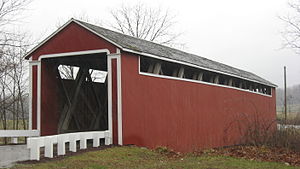
Stockheughter Covered Bridge
United States historic place
Distance: Approx. 6386 meters
Latitude and longitude: 39.33305556,-85.28083333
Stockheughter Covered Bridge, also known as Enochsburg Covered Bridge and County Bridge number 73, is a historic Howe Truss covered bridge located in Ray Township, Franklin County, Indiana. The bridge was built in 1891, and measures 101 feet, 10 inches, long, 13 feet high, and 13 feet wide. It has a gable roof and the exterior is clad in board and natten siding.: 5 It was listed on the National Register of Historic Places in 2002.
Cross Roads, Ripley County, Indiana
Unincorporated community in Indiana, United States
Distance: Approx. 3570 meters
Latitude and longitude: 39.27944444,-85.24166667
Cross Roads is an unincorporated community in Laughery Township, Ripley County, in the U.S. state of Indiana.

Central Batesville Historic District
Historic district in Indiana, United States
Distance: Approx. 921 meters
Latitude and longitude: 39.29777778,-85.22194444
Central Batesville Historic District is a national historic district located at Batesville, Ripley County, Indiana. The district encompasses 44 contributing buildings and 3 contributing structures in the central business district and surrounding residential sections of Batesville. The district developed between about 1852 and 1960 and includes notable examples of Italianate, Queen Anne, Colonial Revival, Tudor Revival, Classical Revival, and Streamline Moderne style architecture.
The Sherman (Batesville, Indiana)
Building in Batesville, Indiana
Distance: Approx. 940 meters
Latitude and longitude: 39.29814,-85.223017
The Sherman, in Batesville, Indiana, is a Tudor-style restaurant and hotel with history dating to 1852. Located "in the heart of historic downtown Batesville, a convenient midway meeting point between Indianapolis and Cincinnati, The Sherman is a well-loved locale for the people of the town and an important Indiana landmark." It is about 3 miles (4.8 km) off Interstate 74. It is one of Indiana's oldest buildings.
Weather in this IP's area
clear sky
14 Celsius
13 Celsius
13 Celsius
16 Celsius
1033 hPa
56 %
1033 hPa
998 hPa
10000 meters
3.6 m/s
120 degree
07:54:03
18:57:26