Country:
 USA
USARegion:
City:
Latitude and Longitude:
Time Zone:
Postal Code:
IP information under different IP Channel
ip-api
Country
Region
City
ASN
Time Zone
ISP
Blacklist
Proxy
Latitude
Longitude
Postal
Route
IPinfo
Country
Region
City
ASN
Time Zone
ISP
Blacklist
Proxy
Latitude
Longitude
Postal
Route
MaxMind
Country
Region
City
ASN
Time Zone
ISP
Blacklist
Proxy
Latitude
Longitude
Postal
Route
Luminati
Country
USRegion
ny
City
groton
ASN
Time Zone
America/New_York
ISP
TVC-AS1
Latitude
Longitude
Postal
db-ip
Country
Region
City
ASN
Time Zone
ISP
Blacklist
Proxy
Latitude
Longitude
Postal
Route
ipdata
Country
Region
City
ASN
Time Zone
ISP
Blacklist
Proxy
Latitude
Longitude
Postal
Route
Popular places and events near this IP address

Summerhill, New York
Town in New York, United States
Distance: Approx. 6995 meters
Latitude and longitude: 42.63916667,-76.32527778
Summerhill is a town in Cayuga County, New York, United States. The population was 1,217 at the 2010 census. The town name is that of a location in Ireland.

Freeville, New York
Village in New York, United States
Distance: Approx. 7967 meters
Latitude and longitude: 42.5125,-76.34583333
Freeville is a village in Tompkins County, New York, United States. The population was 498 at the 2020 census. The Village of Freeville is in the Town of Dryden and is east of Ithaca.

West Dryden Methodist Episcopal Church
Historic church in New York, United States
Distance: Approx. 8452 meters
Latitude and longitude: 42.51722222,-76.415
West Dryden Methodist Episcopal Church is a historic Methodist Episcopal church located at Dryden in Tompkins County, New York. It is a two-story, frame church structure built in 1832 in the Federal style. It was remodeled during 1870–1890.
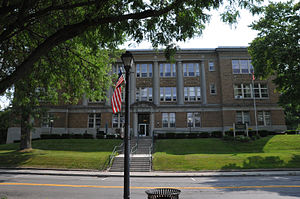
Former Groton High School (Groton, New York)
United States historic place
Distance: Approx. 637 meters
Latitude and longitude: 42.58805556,-76.36666667
Groton High School is a historic high school building located at Groton in Tompkins County, New York. It was built in 1919–1920 and features Classical Revival details, such as six monumental engaged Doric order columns. The front block of the building is three stories in height with a rear projection set back and reduced in height to two, then one, stories and forming a T-shaped configuration.
Groton (village), New York
Village in New York, United States
Distance: Approx. 471 meters
Latitude and longitude: 42.58694444,-76.365
Groton is a village in Tompkins County, New York, United States. The population was 2,363 at the 2010 census. The Village of Groton is near the center of the Town of Groton and is northeast of Ithaca and west of Cortland.
Groton, New York
Town in New York, United States
Distance: Approx. 815 meters
Latitude and longitude: 42.58963889,-76.36719444
Groton is a town in Tompkins County, New York, United States. The population was 5,950 at the 2010 census. The name is taken from Groton, Massachusetts.
Webster Brook
River in New York, United States
Distance: Approx. 6642 meters
Latitude and longitude: 42.5975,-76.28472222
Webster Brook is a river located in Tompkins County, New York. It flows into Fall Creek by Lafayette Corners, New York.
Beaver Creek (Tompkins County, New York)
River in New York, United States
Distance: Approx. 7268 meters
Latitude and longitude: 42.54361111,-76.2925
Beaver Creek is a river located in Tompkins County, New York. It flows into Fall Creek by Malloryville, New York.
Mud Creek (New York)
River in New York, United States
Distance: Approx. 7913 meters
Latitude and longitude: 42.51611111,-76.33027778
Mud Creek is a river located in Tompkins County, New York. It flows into Fall Creek by Freeville, New York.
Mill Creek (Fall Creek tributary)
River in New York, United States
Distance: Approx. 8455 meters
Latitude and longitude: 42.50694444,-76.36388889
Mill Creek is a river located in Tompkins County, New York. It flows into Fall Creek by Freeville, New York.
McLean, New York
Hamlet and CDP in New York, United States
Distance: Approx. 6849 meters
Latitude and longitude: 42.55194444,-76.29111111
McLean is a hamlet (and census-designated place) in Tompkins County, New York, United States. The community is 6.6 miles (10.6 km) west-southwest of Cortland. McLean has a post office with ZIP code 13102, which opened on June 30, 1826.
Groton High School (Groton, New York)
Public high school in Groton, New York, United States
Distance: Approx. 629 meters
Latitude and longitude: 42.58055556,-76.37027778
Groton High School, officially Groton Junior/Senior High School, is the only high school in the Groton Central School District. It serves the Village and Town of Groton, Tompkins County, New York, and extending into areas of Cortland and Cayuga Counties. Its previous building is now listed on the National Register of Historic Places.
Weather in this IP's area
overcast clouds
9 Celsius
6 Celsius
8 Celsius
10 Celsius
1015 hPa
90 %
1015 hPa
973 hPa
10000 meters
5.14 m/s
8.23 m/s
280 degree
100 %
06:38:28
19:27:49