192.240.44.76 - IP Lookup: Free IP Address Lookup, Postal Code Lookup, IP Location Lookup, IP ASN, Public IP
Country:
Region:
City:
Location:
Time Zone:
Postal Code:
IP information under different IP Channel
ip-api
Country
Region
City
ASN
Time Zone
ISP
Blacklist
Proxy
Latitude
Longitude
Postal
Route
Luminati
Country
Region
vt
City
southburlington
ASN
Time Zone
America/New_York
ISP
THE-UNIVERSITY-OF-VERMONT-MEDICAL-CENTER-1
Latitude
Longitude
Postal
IPinfo
Country
Region
City
ASN
Time Zone
ISP
Blacklist
Proxy
Latitude
Longitude
Postal
Route
IP2Location
192.240.44.76Country
Region
new york
City
crown point
Time Zone
America/New_York
ISP
Language
User-Agent
Latitude
Longitude
Postal
db-ip
Country
Region
City
ASN
Time Zone
ISP
Blacklist
Proxy
Latitude
Longitude
Postal
Route
ipdata
Country
Region
City
ASN
Time Zone
ISP
Blacklist
Proxy
Latitude
Longitude
Postal
Route
Popular places and events near this IP address

Crown Point, New York
Town in New York, United States
Distance: Approx. 2726 meters
Latitude and longitude: 43.95027778,-73.43694444
Crown Point is a town in Essex County, New York, United States, located on the west shore of Lake Champlain. The population was 2,024 at the 2010 census. The name of the town is a direct translation of the original French name, Pointe à la Chevelure.

Port Henry, New York
Hamlet and CDP in New York, United States
Distance: Approx. 8714 meters
Latitude and longitude: 44.04527778,-73.46111111
Port Henry is a hamlet (and census-designated place) in Essex County, New York, United States. The population was 1,194 at the 2010 census. Port Henry lies on the eastern side of the town of Moriah and is approximately one hour's drive (52 miles or 84 km) south of Plattsburgh.

Fort Saint-Frédéric
United States historic place
Distance: Approx. 7344 meters
Latitude and longitude: 44.02916667,-73.43111111
Fort Saint-Frédéric was a French fort built on Lake Champlain to secure the region against British colonization and control the lake. It was located in modern New York State across the lake from modern Vermont at the town of Crown Point, New York. The fort, whose construction began in 1734, was never attacked, and was destroyed in 1759 before the advance of a large (more than 10,000 man) British army under General Jeffery Amherst.

Fort Crown Point
United States historic place
Distance: Approx. 7344 meters
Latitude and longitude: 44.02916667,-73.43111111
Fort Crown Point was built by the combined efforts of British and Colonial troops from New York and the New England Colonies in 1759 at a narrows on Lake Champlain on the border between New York and Vermont. It was erected to secure the region against the French in upstate New York near the town of Crown Point, and it was the largest earthen fortress built in the American colonies. The fort's ruins are a National Historic Landmark administered as part of Crown Point State Historic Site.

Chimney Point, Vermont
History museum in Addison, Vermont
Distance: Approx. 8437 meters
Latitude and longitude: 44.03598,-73.418159
Chimney Point is a peninsula in the town of Addison, Vermont, which juts into Lake Champlain forming a narrows. It is one of the earliest settled and most strategic sites in the Champlain Valley. For thousands of years, the locale was occupied by Native Americans.

Crown Point State Historic Site
Distance: Approx. 7339 meters
Latitude and longitude: 44.0287,-73.4295
Crown Point State Historic Site is the site of a former military stronghold at the south end of the wider part of Lake Champlain. The location is in Essex County, New York, United States. The site is on a peninsula in the town of Crown Point, New York.

Crown Point Light
Lighthouse in New York, United States
Distance: Approx. 7707 meters
Latitude and longitude: 44.0299,-73.4216
The Crown Point Light on Lake Champlain is a former lighthouse at Crown Point, New York, that now exists as a memorial to the exploration of the lake by Samuel de Champlain.

Port Henry station
Distance: Approx. 8409 meters
Latitude and longitude: 44.0425,-73.45861111
Port Henry station is an Amtrak intercity train station in Port Henry, New York served by the Adirondack. The station has one low-level side platform on the west side of the track. The station building, designed by architects Fuller & Wheeler, was built in 1888 by the Delaware and Hudson Railroad.

WVTK
Radio station in Port Henry, New York
Distance: Approx. 6854 meters
Latitude and longitude: 44.027,-73.481
WVTK (92.1 MHz) is an FM radio station airing a classic hits radio format, licensed to Port Henry, New York, near the New York State/Vermont border. It is owned by Vox AM/FM, LLC. WVTK has an effective radiated power of 18,000 watts, most of which radiates into the Champlain Valley. The signal can be heard clearly in Middlebury, Bristol, Brandon, Vergennes and Charlotte, Vermont, along with Port Henry, Ticonderoga and Essex, New York.
Crown Point Central School
School district in the U.S. state of New York
Distance: Approx. 3120 meters
Latitude and longitude: 43.95195278,-73.42895833
Crown Point Central School is a school in Essex County, New York, that serves grades Pre-K to Grade 12. The superintendent is Ms. Shari Brannock, and the principal is Ms.

Sherman Free Library
United States historic place
Distance: Approx. 8962 meters
Latitude and longitude: 44.0475,-73.46055556
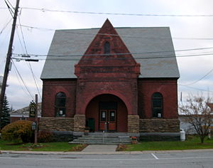
Sherman Free Library is an historic free association library, located in the hamlet of Port Henry, in the town of Moriah, in Essex County, New York. It was built in 1887 and has two rooms, and is a 1+1⁄2-story brick building topped by slate-covered, steeply pitched gable roofs, on a limestone foundation. An addition was built in 1907.

Ironville Historic District
Historic district in New York, United States
Distance: Approx. 7776 meters
Latitude and longitude: 43.92138889,-73.53527778
Ironville Historic District is a national historic district located at Ironville in Essex County, New York. The district contains 12 contributing buildings. It encompasses the area associated with a once thriving iron works.
Weather in this IP's area
few clouds
-11 Celsius
-14 Celsius
-13 Celsius
-11 Celsius
1018 hPa
81 %
1018 hPa
1005 hPa
10000 meters
1.34 m/s
2.24 m/s
339 degree
19 %