192.232.14.140 - IP Lookup: Free IP Address Lookup, Postal Code Lookup, IP Location Lookup, IP ASN, Public IP
Country:
 USA
USARegion:
City:
Location:
Time Zone:
Postal Code:
ISP:
ASN:
language:
User-Agent:
Proxy IP:
Blacklist:
IP information under different IP Channel
ip-api
Country
Region
City
ASN
Time Zone
ISP
Blacklist
Proxy
Latitude
Longitude
Postal
Route
db-ip
Country
Region
City
ASN
Time Zone
ISP
Blacklist
Proxy
Latitude
Longitude
Postal
Route
IPinfo
Country
Region
City
ASN
Time Zone
ISP
Blacklist
Proxy
Latitude
Longitude
Postal
Route
IP2Location
192.232.14.140Country
usRegion
missouri
City
kearney
Time Zone
America/Chicago
ISP
Language
User-Agent
Latitude
Longitude
Postal
ipdata
Country
Region
City
ASN
Time Zone
ISP
Blacklist
Proxy
Latitude
Longitude
Postal
Route
Popular places and events near this IP address

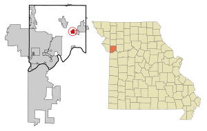
Kearney, Missouri
City in Missouri, United States
Distance: Approx. 1237 meters
Latitude and longitude: 39.355,-94.35972222
Kearney is a city in Clay County, Missouri, United States. The population per the 2020 U.S. census was 10,404. The city was the birthplace of Jesse James, and there is an annual festival in the third weekend of September to recognize the outlaw.
Mosby, Missouri
City in Missouri, United States
Distance: Approx. 7067 meters
Latitude and longitude: 39.31638889,-94.30944444
Mosby is a city in Clay County, Missouri, United States, along the Fishing River. The population was 101 at the 2020 census. It is part of the Kansas City metropolitan area.

Brushy Creek (Fishing River tributary)
Stream in the American state of Missouri
Distance: Approx. 7226 meters
Latitude and longitude: 39.3227797,-94.423006
Brushy Creek is a stream in Clay County in the U.S. state of Missouri. It is a tributary of the Fishing River. Brushy Creek was so named on account of brush lining its banks.
Carroll Creek (Clear Creek tributary)
Stream in Missouri, United States
Distance: Approx. 4710 meters
Latitude and longitude: 39.3394475,-94.3180027
Carroll Creek is a stream in the U.S. state of Missouri. It is a tributary of Clear Creek. Carroll Creek has the name of a pioneer citizen.
Chandler, Missouri
Unincorporated community in the American state of Missouri
Distance: Approx. 7574 meters
Latitude and longitude: 39.30027778,-94.38277778
Chandler is an unincorporated community in Clay County, in northwest Missouri. The community is on the Burlington Northern Railroad Line between Liberty and Kearney. Holmes Creek flows past the community.
Clear Creek (Fishing River tributary)
Stream in the U.S. state of Missouri
Distance: Approx. 6036 meters
Latitude and longitude: 39.32361111,-94.31694444
Clear Creek is a stream in Clay and Clinton counties of northwest Missouri. It is a tributary of the Fishing River. The headwaters of the stream are in Clinton County southwest of Lathrop and it flows south-southwest into Clay County turning to the southeast to the east of Arley.
Crockett Creek
Stream in Clay County, Missouri, U.S.
Distance: Approx. 7132 meters
Latitude and longitude: 39.3136143,-94.3130029
Crockett Creek is a stream in Clay County in the U.S. state of Missouri. Crockett Creek has the name of David Crockett, a local settler and relative of Davy Crockett.
Holmes Creek
Stream in the U.S. state of Missouri
Distance: Approx. 8005 meters
Latitude and longitude: 39.31361111,-94.29694444
Holmes Creek is a stream in Clay County in the U.S. state of Missouri. It is a tributary to the Fishing River. The stream headwaters arise at 39°17′23″N 94°23′14″W just south of U.S. Route 69.
Gallatin Township, Clay County, Missouri
Township in Clay County, Missouri, U.S.
Distance: Approx. 3742 meters
Latitude and longitude: 39.3908,-94.39
Gallatin Township is an inactive township in Clay County, in the U.S. state of Missouri. Gallatin Township was established in the early 1820s, taking its name from Albert Gallatin.
Kearney Township, Clay County, Missouri
Defunct township, Clay County, Missouri
Distance: Approx. 3971 meters
Latitude and longitude: 39.393428,-94.390154
Kearney Township is an inactive township in Clay County, in the U.S. state of Missouri. Kearney Township was erected in 1872, taking its name from Kearney, Missouri.

Claybrook House (Kearney, Missouri)
Historic house in Missouri, United States
Distance: Approx. 3237 meters
Latitude and longitude: 39.38805556,-94.33583333
Claybrook House is a historic home located near Kearney, Clay County, Missouri. It was built about 1858, and is a two-story, L-shaped, Federal style frame dwelling. It features a Greek Revival style entrance surrounded by 14 window lights.: 2 It was listed on the National Register of Historic Places in 1981.

James Brothers' House and Farm
Historic house in Missouri, United States
Distance: Approx. 4512 meters
Latitude and longitude: 39.39333333,-94.32166667
James Brothers' House and Farm, also known as the Birthplace of Jesse James, is a historic home and farm complex located near Kearney, Clay County, Missouri. The original log section of the farmhouse was built about 1822; it was later enlarged with a wood-frame addition to form a "T"-plan dwelling. The James Brothers' House is significant as the birthplace of Jesse James and Frank James and has been selected as the most important site related to the James Brothers in Missouri.: 2 In 1974 Clay County, Missouri, bought it.
Weather in this IP's area
overcast clouds
2 Celsius
-2 Celsius
2 Celsius
3 Celsius
1020 hPa
59 %
1020 hPa
986 hPa
10000 meters
4.63 m/s
120 degree
100 %