192.219.119.147 - IP Lookup: Free IP Address Lookup, Postal Code Lookup, IP Location Lookup, IP ASN, Public IP
Country:
Region:
City:
Location:
Time Zone:
Postal Code:
ISP:
ASN:
language:
User-Agent:
Proxy IP:
Blacklist:
IP information under different IP Channel
ip-api
Country
Region
City
ASN
Time Zone
ISP
Blacklist
Proxy
Latitude
Longitude
Postal
Route
db-ip
Country
Region
City
ASN
Time Zone
ISP
Blacklist
Proxy
Latitude
Longitude
Postal
Route
IPinfo
Country
Region
City
ASN
Time Zone
ISP
Blacklist
Proxy
Latitude
Longitude
Postal
Route
IP2Location
192.219.119.147Country
Region
saskatchewan
City
saskatoon
Time Zone
America/Regina
ISP
Language
User-Agent
Latitude
Longitude
Postal
ipdata
Country
Region
City
ASN
Time Zone
ISP
Blacklist
Proxy
Latitude
Longitude
Postal
Route
Popular places and events near this IP address

University Bridge (Saskatoon)
Bridge in Saskatchewan, Canada
Distance: Approx. 738 meters
Latitude and longitude: 52.13027778,-106.64916667
The University Bridge spans the South Saskatchewan River between Clarence Avenue and College Drive on the east shore with 25th Street on the west in Saskatoon, Saskatchewan Canada. The bridge is also known as the 25th Street Bridge and is a major commuter route between the two halves of Saskatoon. Between its opening in 1916 and the opening of the Circle Drive Bridge in 1983, it was the northernmost vehicular river crossing in the city.

Johnson Shoyama Graduate School of Public Policy
Public policy school in Saskatchewan, Canada
Distance: Approx. 897 meters
Latitude and longitude: 52.134325,-106.64026389
Established in 2007, the Johnson Shoyama Graduate School of Public Policy (JSGS) is a centre for advanced education, research and training in policy and administration. It has locations at the University of Regina and the University of Saskatchewan. The school is named after two of Saskatchewan's best-known public servants, Albert Wesley Johnson and Thomas Shoyama.
Cathedral of St. John the Evangelist (Saskatoon)
Church in Saskatchewan, Canada
Distance: Approx. 763 meters
Latitude and longitude: 52.129905,-106.655917
The Cathedral of St. John the Evangelist, located at 816 Spadina Crescent East in the Central Business District neighbourhood of Saskatoon, Saskatchewan, Canada is the cathedral of the Anglican Diocese of Saskatoon.

City Park, Saskatoon
Neighbourhood in Saskatoon, Saskatchewan, Canada
Distance: Approx. 109 meters
Latitude and longitude: 52.13555556,-106.65333333
City Park is a mixed-use neighbourhood located near the center of Saskatoon, Saskatchewan, Canada. It comprises a mix of single-family detached homes, apartment buildings and other semi-detached dwellings. It also contains a number of commercial zones with businesses.

Saskatoon City Hospital
Hospital in Saskatoon, Saskatchewan, Canada
Distance: Approx. 110 meters
Latitude and longitude: 52.13574,-106.65394
Saskatoon City Hospital is a public hospital in the City Park neighbourhood of Saskatoon, Saskatchewan, Canada. The original hospital was opened in 1909 and was the second municipal hospital in Canada. The original structure was closed and demolished in the early 1990s, with a new City Hospital opening in 1993.

Hallmark Place
Residential in Saskatchewan, Canada
Distance: Approx. 623 meters
Latitude and longitude: 52.13116944,-106.65565833
Hallmark Place is an apartment building located at 311 6th Avenue North in the Central Business District of Saskatoon, Saskatchewan, Canada. The building has 27 stories (78.8 m) and is the third tallest building in the city. The building is a condominium development where, in addition to individual owners, a number of units are offered as short-term business suites.

Spadina Crescent Bridge (Saskatoon)
Bridge in Saskatoon, Saskatchewan, Canada
Distance: Approx. 321 meters
Latitude and longitude: 52.13583333,-106.64833333
Spadina Crescent Bridge is a deck arch bridge that spans a ravine in City Park along Spadina Crescent in Saskatoon, Saskatchewan, Canada. The bridge was constructed in 1930, replacing an earlier wooden structure. It was built by the Saskatoon Contracting Co., owned by Leon and Paul Prescesky.

Knox United Church (Saskatoon)
Church
Distance: Approx. 667 meters
Latitude and longitude: 52.13058889,-106.6545
Knox United Church is a designated municipal heritage building at 838 Spadina Crescent East, in the Central Business District, of Saskatoon, Saskatchewan, Canada. The congregation was established as part of the Saskatoon Presbyterian Field Mission in 1885 after the North-West Rebellion. Meetings were held in homes, the Old Stone Schoolhouse, the Methodist Church and even the railway roundhouse until a wood church holding 160 was constructed near the river.

Arthur Cook Building
Distance: Approx. 956 meters
Latitude and longitude: 52.1325,-106.66527778
The Arthur Cook Building (built in 1928) is a designated historic building in the Central Business District, of Saskatoon, Saskatchewan, Canada. The three-storey brick and concrete warehouse was built in 1928 by the Saskatoon Cartage and Warehouse Company. It was designed by Saskatoon architect David Webster and built by the A.W. Cassidy Co.

Modern Press Building
Building in Saskatchewan, Canada
Distance: Approx. 554 meters
Latitude and longitude: 52.13444444,-106.66027778
The Modern Press Building (originally built in 1927 and thoroughly renovated in 1947, 1993, and 2012) is a historic building in the City Park District, of Saskatoon, Saskatchewan, Canada. The original building was designed by David Webster. The building was originally built as a two-story art deco building to house the Modern Press printing-press equipment and offices.

Downtown Saskatoon bus terminal
Distance: Approx. 941 meters
Latitude and longitude: 52.13027778,-106.66222222
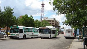
The Downtown Saskatoon bus terminal is a bus terminal for Saskatoon Transit in the Central Business District of Saskatoon, Saskatchewan. It is located on 23rd Street between 2nd Avenue and 3rd Avenue. There is a small customer service centre, where people can buy or re-load a Go-Pass smart card, or get info on Saskatoon Transit services.

Jim Pattison Children's Hospital
Hospital in Saskatoon, Saskatchewan, Canada
Distance: Approx. 873 meters
Latitude and longitude: 52.13194444,-106.6425
Jim Pattison Children's Hospital is one of four hospitals in Saskatoon, Saskatchewan. It is located on the University of Saskatchewan campus and is connected via corridor to the Royal University Hospital. It is located along the banks of the South Saskatchewan River.
Weather in this IP's area
scattered clouds
-4 Celsius
-11 Celsius
-4 Celsius
-4 Celsius
1011 hPa
85 %
1011 hPa
949 hPa
10000 meters
6.17 m/s
290 degree
40 %
