Country:
 France
Region:
City:
Latitude and Longitude:
Time Zone:
Postal Code:
IP information under different IP Channel
ip-api
Country
Region
City
ASN
Time Zone
ISP
Blacklist
Proxy
Latitude
Longitude
Postal
Route
IPinfo
Country
Region
City
ASN
Time Zone
ISP
Blacklist
Proxy
Latitude
Longitude
Postal
Route
MaxMind
Country
Region
City
ASN
Time Zone
ISP
Blacklist
Proxy
Latitude
Longitude
Postal
Route
Luminati
Country
FRASN
Time Zone
Europe/Paris
ISP
ADISTA SAS
Latitude
Longitude
Postal
db-ip
Country
Region
City
ASN
Time Zone
ISP
Blacklist
Proxy
Latitude
Longitude
Postal
Route
ipdata
Country
Region
City
ASN
Time Zone
ISP
Blacklist
Proxy
Latitude
Longitude
Postal
Route
Popular places and events near this IP address
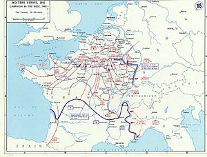
Battle of Saumur (1940)
A battle during World War II
Distance: Approx. 5464 meters
Latitude and longitude: 47.26,0.07694444
The Battle of Saumur occurred during the last stages of the Battle of France during World War II, when officer cadets from the Cavalry School at Saumur, led by superintendent Colonel Charles Michon, made a defensive stand along the Loire River at Saumur, Gennes, and Montsoreau. For two days the Cavalry School, and other assorted units which had fallen back before the German Wehrmacht advance, held off a German attack. Since the battle occurred after the message by Marshal Pétain which called for an end to fighting (on 17 June 1940), the event is often considered one of the first acts of the French Resistance.
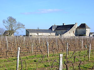
Allonnes, Maine-et-Loire
Commune in Pays de la Loire, France
Distance: Approx. 96 meters
Latitude and longitude: 47.2939,0.0244
Allonnes (French pronunciation: [alɔn] ) is a commune in the Maine-et-Loire department in western France. The village is located North of the town of Saumur, and the small river Authion passes through it.
Brain-sur-Allonnes
Commune in Pays de la Loire, France
Distance: Approx. 3389 meters
Latitude and longitude: 47.3031,0.0661
Brain-sur-Allonnes (French pronunciation: [bʁɛ̃ syʁ alɔn] , literally Brain on Allonnes) is a commune in the Maine-et-Loire department in western France.
La Breille-les-Pins
Commune in Pays de la Loire, France
Distance: Approx. 6781 meters
Latitude and longitude: 47.3414,0.0786
La Breille-les-Pins (French pronunciation: [la bʁɛj le pɛ̃] ) is a commune in the Maine-et-Loire department in western France.
Neuillé
Commune in Pays de la Loire, France
Distance: Approx. 6973 meters
Latitude and longitude: 47.3422,-0.0339
Neuillé (French pronunciation: [nœje] ) is a commune in the Maine-et-Loire department in western France.

Souzay-Champigny
Commune in Pays de la Loire, France
Distance: Approx. 6775 meters
Latitude and longitude: 47.236,-0.007
Souzay-Champigny (French pronunciation: [suzɛ ʃɑ̃piɲi] ) is a commune in the Maine-et-Loire department in western France.
Turquant
Commune in Pays de la Loire, France
Distance: Approx. 7822 meters
Latitude and longitude: 47.223,0.028
Turquant (French pronunciation: [tyʁkɑ̃] ) is a commune in the Maine-et-Loire department in western France.

Varennes-sur-Loire
Commune in Pays de la Loire, France
Distance: Approx. 6454 meters
Latitude and longitude: 47.239,0.054
Varennes-sur-Loire (French pronunciation: [vaʁɛn syʁ lwaʁ] , literally Varennes on Loire) is a commune in the Maine-et-Loire department in western France.

Villebernier
Commune in Pays de la Loire, France
Distance: Approx. 5987 meters
Latitude and longitude: 47.253,-0.029
Villebernier (French pronunciation: [vilbɛʁnje] ) is a commune in the Maine-et-Loire department in western France. It is located on the Northern bank of the Loire river, between Angers and Tours. A couple of architectural treasures can be found in the village.
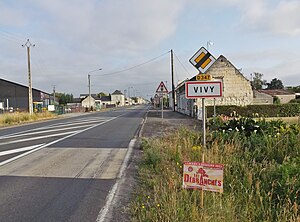
Vivy, Maine-et-Loire
Commune in Pays de la Loire, France
Distance: Approx. 6901 meters
Latitude and longitude: 47.327,-0.053
Vivy (French pronunciation: [vivi] ) is a commune in the Maine-et-Loire department in western France.

Parnay, Maine-et-Loire
Commune in Pays de la Loire, France
Distance: Approx. 6911 meters
Latitude and longitude: 47.2319,0.0092
Parnay (French pronunciation: [paʁnɛ] ) is a commune in the Maine-et-Loire department in western France. It is known for its 11th-Century church. Parnay is one of the nine communes that is in the AOC Saumur-Champigny and fruit Red Wine made from Cabernet Franc.

Saumur station
Distance: Approx. 7671 meters
Latitude and longitude: 47.26888889,-0.07138889
Saumur station (French: Gare de Saumur), also known as Saumur-Rive-Droite is a railway station serving the town Saumur, Maine-et-Loire department, western France. It is situated on the Tours–Saint-Nazaire railway.
Weather in this IP's area
overcast clouds
13 Celsius
13 Celsius
13 Celsius
13 Celsius
1000 hPa
94 %
1000 hPa
997 hPa
10000 meters
4.39 m/s
10.35 m/s
179 degree
98 %
08:08:37
19:25:49