192.203.138.46 - IP Lookup: Free IP Address Lookup, Postal Code Lookup, IP Location Lookup, IP ASN, Public IP
Country:
Region:
City:
Location:
Time Zone:
Postal Code:
IP information under different IP Channel
ip-api
Country
Region
City
ASN
Time Zone
ISP
Blacklist
Proxy
Latitude
Longitude
Postal
Route
Luminati
Country
ASN
Time Zone
Asia/Seoul
ISP
JEJU NATIONAL UNIVERSITY
Latitude
Longitude
Postal
IPinfo
Country
Region
City
ASN
Time Zone
ISP
Blacklist
Proxy
Latitude
Longitude
Postal
Route
IP2Location
192.203.138.46Country
Region
jeju-teukbyeoljachido
City
jeju
Time Zone
Asia/Seoul
ISP
Language
User-Agent
Latitude
Longitude
Postal
db-ip
Country
Region
City
ASN
Time Zone
ISP
Blacklist
Proxy
Latitude
Longitude
Postal
Route
ipdata
Country
Region
City
ASN
Time Zone
ISP
Blacklist
Proxy
Latitude
Longitude
Postal
Route
Popular places and events near this IP address

Jeju City
City in Jeju, South Korea
Distance: Approx. 36 meters
Latitude and longitude: 33.513,126.523
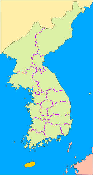
Jeju City (Korean: 제주시, romanized: Jeju-si; Korean pronunciation: [tɕe̞.dʑu]) is the capital of the Jeju Province in South Korea and the largest city on Jeju Island. The city is served by Jeju International Airport (IATA code CJU). Located on an island off the Korean Peninsula, Jeju has mild, warm weather during much of the year.
Jeju National University Teachers College
Part of Cheju National University
Distance: Approx. 2715 meters
Latitude and longitude: 33.51472222,126.5525
Jeju National University of Education was the only teacher-training university on South Korea's Jeju Island. It was located in the provincial capital, Jeju City. It merged with Cheju National University and its campus is used as Sara Campus of Cheju National University in 2008.

Roman Catholic Diocese of Jeju
Roman Catholic diocese in South Korea
Distance: Approx. 1593 meters
Latitude and longitude: 33.5,126.51666667
The Roman Catholic Diocese of Jeju (제주, also romanized Jeju, Latin: Dioecesis Cheiuensis) is a Latin rite suffragan diocese in the ecclesiastical province of the Metropolitan Archdiocese of Gwangju, South Korea, yet depends on the missionary Dicastery for Evangelization. Its episcopal see and mother church is Immaculate Conception Cathedral in Jeju City.
Jeju Stadium
Stadium in Jeju City, South Korea
Distance: Approx. 1994 meters
Latitude and longitude: 33.49718889,126.51365833
The Jeju Stadium (Korean: 제주종합경기장; Hanja: 濟州綜合競技場) is a multi-purpose stadium in Jeju City, Jeju Province, South Korea. It is currently used mostly for football matches. The stadium was used by K League team Jeju United between 2007 and 2010.

Jeju National Museum
Museum in Jeju, South Korea
Distance: Approx. 2293 meters
Latitude and longitude: 33.513,126.548
Jeju National Museum (Korean: 국립제주박물관) is an archeological and local history museum located in Jeju, South Korea. It opened on June 15, 2001. Construction of the museum began in December 1992 and ended on December 28, 2000.
Jeju Baseball Stadium
Stadium in Jeju Province, South Korea
Distance: Approx. 2114 meters
Latitude and longitude: 33.495728,126.514378
Jeju Baseball Stadium (Korean: 제주오라종합경기장 야구장) is a baseball stadium in Jeju City, Jeju, South Korea. It is used mostly for baseball games and is the second home stadium of Nexen Heroes.
Yonghwasa
Distance: Approx. 790 meters
Latitude and longitude: 33.51559,126.51528
Yonghwasa (Korean: 용화사; Hanja: 龍華寺), sometimes Dragon Pool Temple, is a Buddhist temple in Yongdamdong, Yongyeon (龍淵) region in Jeju City, South Korea. The temple, set within a walled compound and located on the west side of Cheju Castle, contains a phallic shrine which was visited by female pilgrims who came to worship it for its alleged fertility blessings. The phallic stone is made from granite, quite small in size, and white, and was reportedly found in a nearby field by a farmer.

Port of Jeju
Port in South Korea
Distance: Approx. 1920 meters
Latitude and longitude: 33.5224,126.5408
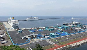
The Port of Jeju (Korean: 제주항; Hanja: 濟州港) is a port and cruise ship terminal in South Korea, located in the city of Jeju. The Port of Jeju is used for cruise ships and exports of goods. Jeju island is home to the second biggest airport in South Korea after Incheon.
Immaculate Conception Cathedral, Jeju
Church in Jeju, South Korea
Distance: Approx. 177 meters
Latitude and longitude: 33.51163889,126.52291667
The Immaculate Conception Cathedral (Korean: 중앙성당), also called Jungang Cathedral of the Immaculate Conception of Mary and locally Jungang Cathedral, is a religious building located in Jeju City, South Korea. The temple follows the Roman or Latin rite and is the principal church of the Diocese of Jeju (Dioecesis Cheiuensis; 제주 교구) which was raised to its current status in 1977 by Pope Paul VI by bull "Munus Apostolicum". It is under the pastoral responsibility of the Bishop Peter Kang U-il.

Naewat-dang shamanic paintings
Series of portraits of shamanic deities from Jeju, South Korea
Distance: Approx. 1254 meters
Latitude and longitude: 33.50833333,126.51111111
The Naewat-dang shamanic paintings (Korean: 내왓당 무신도) are ten portraits of village patron gods formerly hung at the Naewat-dang shrine, one of the four state-recognized shamanic temples of Jeju Island, now in South Korea. The shrine was destroyed in the nineteenth century, and the works are currently preserved at Jeju National University as a government-designated Important Folklore Cultural Property. They may be the oldest Korean shamanic paintings currently known.
Jeju Dongmun Traditional Market
Traditional market in Jeju, South Korea
Distance: Approx. 335 meters
Latitude and longitude: 33.5122,126.5267
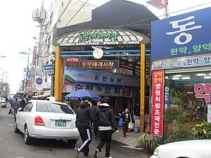
Jeju Dongmun Traditional Market (Korean: 제주 동문재래시장) is a covered traditional market in Jeju City, Jeju Province, South Korea. It is the largest and oldest extant permanent traditional market in Jeju. The market was established after the end of the Japanese colonial period.
Wardah (restaurant)
Yemeni restaurant in Jeju City, South Korea
Distance: Approx. 246 meters
Latitude and longitude: 33.511,126.5231
Wardah (Korean: 와르다; Arabic: وردة, lit. 'flower') is a Yemeni restaurant in Jeju City, South Korea. It first opened on November 7, 2018. It was reported in 2019 that the restaurant is one of very few halal restaurants in Jeju Province.
Weather in this IP's area
broken clouds
7 Celsius
4 Celsius
7 Celsius
7 Celsius
1029 hPa
53 %
1029 hPa
1027 hPa
10000 meters
5.66 m/s
310 degree
75 %

